-
1) This map of Alaska has been divided into four major regions: the southern,
or Gulf of Alaska, region, the continental, or interior, region in
the center, the Bering Sea region to the west, and the Artic region
to the north. The delineation of these regions is based on information
found pertaining to ecoregions in the state, (see http://www-eros-afo.wr.usgs.gov/ecoreg/ecoreg/ecoremap.html).
In the four regions specified, various ecoregions, holding similar
characteristics have been joined. The regions are similar, as well,
to those defined by Hartman and Johnson in The Environmental Atlas
of Alaska, (University of Alaska, 1984, Fairbanks). The regions are, in
general, thus described:
-
Southern Alaska: small temp variations, high humidity, high precipitation,
and high cloud and fog frequency.
-
Bering region: transitional--more pronounced temp variations throughout
the day and year, lower precipitation and humidity.
-
Continental: high diurnal and annual temp variations, low precipitation,
and low cloudiness.
-
Arctic: less temp variation than continental, precipitation is light--the
summer may see some marine influence, but not much at all is seen in the
winter, when the Arctic is frozen
-
2) http://fermi.jhuapl.edu/states/maps1/ak.gif
Topographic
map of Alaska. Make notice comparing this to the regional map, that the
Southern region is defined to the north by the ranges of mountains,
(creating a transition between the maritime climate of the south
and the continental climate of the interior)
-
3) http://climate.oA.alaska.edu/AKCityClimo/ALL_Rec.html
Alaska city climate trends--30 year running average temperature comparisons:
This graph illustrates the trend of decreasing temperatures as one
moves north through the state, (Juneau being the southern-most city
on the graph and Barrow the northern-most).
-
4) http://climate.gi.alaska.edu/AKCityClimo/ALL_pcpn.html
The
THIRD graph down at this sight illustrates the trend of decreasing
precipitation as one moves along a gradient moving north through
Alaska, with the exception in the mid-summer months with Nome receiving
more precipitation than Anchorage, because of its location on the
Bering Sea.
-
5) http://climate.gi.alaska.edu/AKCityClimo/ALL_sf.html
The THIRD graph down shows the precipitation at the same six cities
as the last graph. It illustrates the significant difference in daily
amount snowfall between Juneau (in the Southern region) and Barrow,
(in the Arctic region). The Southern region receives more snowfall.
-
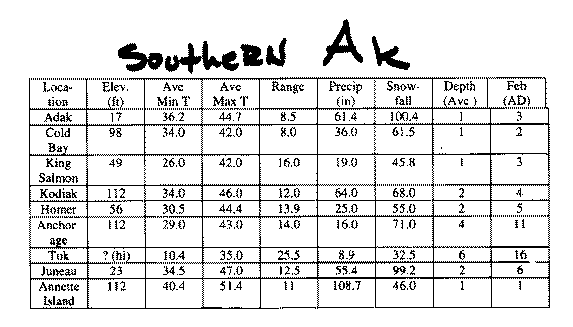
6) Southern Alaska chart of average temp and precipitation. Temp is in
deees Fahrenheit and the average precipitations, snowfalls, and depths
are in inches. The small temperature ranges, moderate temperatures,
and high precipitation and snowfall, with relatively low average
depth are all indicative of a moderate maritime climate.
-
7)Interior Alaska chart of mean temperatures and precipitations at various
times of the year. The great annual range in temperature is characteristic
of this region where the winter are colder and the summers are warmer.

Other sources of interest:
http://www.wrcc.sage.dri.edu/cgi-bin/cliMAIN.pl?ak
http://www-eros-afo.wr.usgs.gov/ecoreg/ecoregmap.html
http://www.uaa.alaska.edu/enri/ascc_web/nwss/nws.html