1. Glacier Change
1. Glacier Change
OVERVIEW OF GLACIAL CHANGE IN PAST 200 YEARS
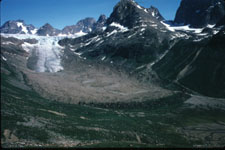
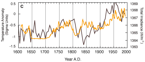
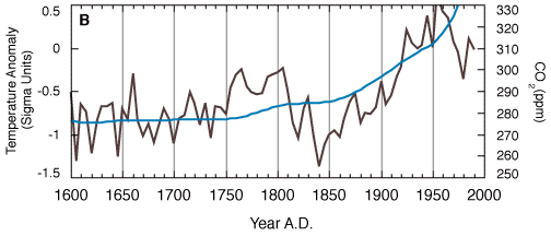
Up until around the end of the nineteenth century, the earth was
in the midst of a cooler period known as the Little Ice Age. During this
time the cryosphere extended it's grasp on the earth. There was glacial
expansion in most areas and the mean temperature was about 1 degree celsius
cooler than the mean today.
After the end of the Little Ice Age around 1890, the earth began
to experience a period of overall glacial retreat related to warmer temperatures
and a negative glacial balance cycle. In most parts of the world the glaciers
that influence albedo and other parts of climate are
disappearing. Of course there are anomalies and Scandinavia is one
of them. Due to an increased maritime flow there , year round, the
accumulation is greater than the ablation (erosive processes that shrink
glaciers) and consequently, the glaciers are growing.
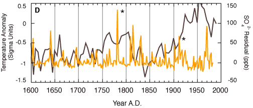
The data obtained comes from recorded observations, tree ring
records and ice core samples. There is a fairly good complete record that
can be obtained from these sources for the past 200 years. The reasoning
for the increase of glacial retreat is thought to be
increased solar radiation as well as increased temperatures due to
buildup of greenhouse gases that commenced with the start of the Industrial
Revolution.
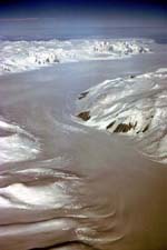
Please see some of the links off of this website for more information
on glacial change on the past 200 years as well as some photos of glaciers,
both past and present.
http://www.ngdc.noaa.gov/paleo/
http://www.antcrc.utas.edu/antcrc/seaice/seaice.html
http://tawny.bu.edu/JandJ/Journal/SCAN/960616/html
This is a good site for photos.
http://www.xstall.nl/~pal/svartise.html
http://www-nsidc.colorado.edu/NOAA/glacier_inventory
http://www.geo.unizh.cg/wgms/mbb
http://www.natgeo.su.se/naturogeo/glaciologi/home.html
http://www.flag.wr.usgs.gov/GLIMS/glimshome/html
| Name | b94 [mm] | b95 [mm] | ELA94 [m a.s.l.] | ELA95 [m a.s.l.] | ELA0 [m a.s.l.] | AAR94 [%] | AAR95 [%] | AAR0 [%] |
|---|---|---|---|---|---|---|---|---|
| Helm (1975) Canada | - 1885 | - 1465 | >21792) | >21792) | 2014 | 0 | 0 | 35 |
| Peyto (1966) Canada | - 1295 | - 300 | 2754 | 2675 | 2625 | 28 | 43 | 53 |
| Place (1965) Canada | - 2010 | - 2486 | 2445 | >26102) | 2088 | 4 | 0 | 48 |
| White (1960) Canada | - 314 | - 362 | 1325 | 1204 | 898 | 28 | 46 | 71 |
| Gulkana (1966) USA | - 640 | - 1070 | 1769 | 1824 | 1727 | 57 | 50 | 63 |
| Wolverine (1966) USA | - 680 | - 500 | 1198 | 1180 | 1156 | 61 | 63 | 62 |
| South Cascade (1953) USA | - 1020 | - 690 | 2005 | 1945 | 1890 | 11 | 25 | 58 |
| Chacaltaya (1992) Bolivia | - 1107 | - 1524 | 5320 | 5320 | - | 4 | 0 | - |
| Zongo (1992) Bolivia | - 650 | - 1250 | 5300 | 5350 | - | 58 | 53 | - |
| Hofsjökull North (1988)Iceland | + 80 | - 680 | 1250 | 1330 | 1269 | 50 | 38 | 48 |
| Hofsjökull Southwest (1989)Iceland | - 740 | - 1170 | 1310 | 1345 | 1258 | 34 | 27 | 41 |
| Hofsjökull East (1989)Iceland | - 180 | - 800 | 1155 | 1285 | 1161 | 59 | 47 | 56 |
| Brúarjökull (1993) Iceland | + 550 | - 342 | 1140 | 1260 | - | 67 | 52 | - |
| Dyngjujökull (1992)Iceland | + 190 | + 20 | 1250 | 1310 | - | 71 | 60 | - |
| Eyjabakkajökull (1991) Iceland | + 460 | - 420 | 1045 | 1145 | - | 61 | 44 | - |
| Thrándarjökull (1991)Iceland | + 400 | - 990 | 1020 | >12402) | - | 74 | 0 | - |
| Austre Brøggerbreen (1967) Norway | - 160 | - 780 | 310 | 500 | 275 | 48 | 8 | 55 |
| Midtre Lovénbreen (1968) Norway | - 120 | - 790 | 270 | 500 | 294 | 66 | 6 | 60 |
| Kongsvegen (1987) Norway | + 500 | - 350 | 400 | 650 | 540 | 78 | 28 | 54 |
| Hansbreen (1989) Norway | + 222 | - 418 | 240 | 400 | 300 | 71 | 25 | 54 |
| Storsteinsfjellbreen (1991) Norway | - 210 | + 570 | 1375 | 1280 | - | 57 | 74 | - |
| Engabreen (1970) Norway | + 420 | + 1700 | 1080 | 940 | 1163 | 76 | 91 | 58 |
| Okstindbreen (1987) Norway | - 170 | + 460 | 1310 | 1275 | 1295 | 61 | 69 | 64 |
| Austdalsbreen (1988) Norway | - 70 | + 620 | 1425 | 1360 | 1430 | 69 | 80 | 62 |
| Ålfotbreen (1963) Norway | + 780 | + 1200 | 925 | 1120 | 1193 | 99.5 | 79 | 56 |
| Nigardsbreen (1962) Norway | + 560 | + 1190 | 1400 | 1320 | 1559 | 87 | 91 | 59 |
| Gråsubreen (1962) Norway | 0 | - 110 | 2070 | 2180 | 2127 | 40 | 11 | 30 |
| Storbreen (1949) Norway | - 250 | - 150 | 1800 | 1810 | 1709 | 39 | 35 | 60 |
| Hellstugubreen (1962) Norway | + 70 | - 120 | 1860 | 1885 | 1834 | 59 | 53 | 58 |
| Hardangerjøkulen (1963) Norway | + 160 | + 300 | 1610 | 1575 | 1664 | 82 | 85 | 68 |
| Riukojietna (1986) Sweden | - 295 | + 253 | 1410 | 1287 | 1352 | 26 | 85 | 54 |
| Mårmaglaciären (1990) Sweden | - 340 | + 100 | 1619 | 1521 | 1571 | 23 | 59 | 42 |
| Storglaciären (1946) Sweden | - 370 | + 700 | 1500 | 1400 | 1462 | 41 | 57 | 45 |
| Rabots glaciär (1982) Sweden | - 100 | + 80 | 1350 | 1351 | 1358 | 57 | 57 | 53 |
| Saint Sorlin (1959) France | - 340 | + 750 | - | - | - | - | - | |
| Sarennes (1949) France | - 630 | + 760 | - | - | - | - | - | - |
| Silvretta (1960) Switzerland | - 460 | + 370 | 2912 | 2704 | 2767 | 24 | 70 | 53 |
| Gries (1962) Switzerland | - 760 | - 70 | 2953 | 2799 | 2833 | 48 | 67 | 58 |
| Sonnblickkees (1959) Austria | - 1385 | + 141 | 2950 | 2720 | 2738 | 9 | 70 | 60 |
| Sonnblickkees (1959) Austria | - 1617 | - 414 | 3170 | 2940 | 2786 | 5 | 32 | 44 |
| Vernagtferner (1965) Austria | - 1028 | - 400 | >36502) | 3226 | 3083 | 22 | 40 | 67 |
| Ochsentalferner (1991) Austria | - 980 | + 50 | 2990 | 2845 | - | 34 | 63 | - |
| Vermuntgletscher (1991) Austria | - 1450 | - 240 | >31502) | 2845 | - | 4 | 41 | - |
| Kesselwandferner (1953) Austria | - 830 | + 140 | 3240 | 3080 | 3102 | 33 | 78 | 71 |
| Hintereisferner (1953) Austria | - 1110 | - 460 | 3145 | 3080 | 2921 | 31 | 53 | 66 |
| Jamtalferner (1989) Austria | - 830 | - 150 | >31502) | 2820 | - | 18 | 63 | - |
| Caresèr (1967)Italy | - 1740 | - 1080 | >33302) | >33302) | 3094 | 19 | 0 | 48 |
| Fontana Bianca (1984)Italy | - 955 | - 682 | >34402) | >34402) | - | 0 | 0 | - |
| Maladeta (1992) Spain | + 351 | - 643 | 3028 | 3075 | - | 49 | 31 | - |
| Lewis3) (1979) Kenya | - 1920 | - 450 | 45002) | 4810 | 4795 | 0 | 46 | 58 |
| Kozelskiy (1973) Russia | - 670 | - 230 | 1730 | 1680 | 1464 | 37 | 45 | 51 |
| No. 125 (Vodopadniy) (1977) Russia | - 210 | + 50 | 3240 | 3210 | 3213 | 68 | 72 | 65 |
| Maliy Aktru (1962) Russia | - 150 | + 160 | 3230 | 3200 | 3138 | 67 | 75 | 71 |
| Leviy Aktru (1977) Russia | - 360 | - 30 | 3250 | 3130 | 3153 | 56 | 67 | 60 |
| Garabashi (1987) Russia | - 430 | - 10 | 3890 | 3850 | 3794 | 48 | 55 | 60 |
| Djankuat (1968) Russia | - 840 | + 40 | 3330 | 3190 | 3191 | 44 | 62 | 60 |
| Kara-Batkak (1957) Kirghizstan | - 505 | - 515 | 3900 | 3950 | 3847 | 49 | 54 | 56 |
| Abramov (1968) Kirghizstan | - 750 | - 780 | 4250 | 4240 | 4153 | 46 | 44 | 59 |
| Ts. Tuyuksuyskiy (1957) Kazakhstan | - 443 | - 587 | 3820 | 3820 | 3740 | 44 | 31 | 54 |
| Urumqihe S. No. 1 (1959) China | - 378 | - 228 | 4058 | 4035 | 4026 | 40 | 50 | 55 |
1) Numbers in brackets behind the glacier names indicate the beginning
of continuous mass balance records.
2) Above glacier maximum elevation.
3) Note that the balance year here starts in March of the year indicated.
2 Desertification