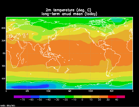
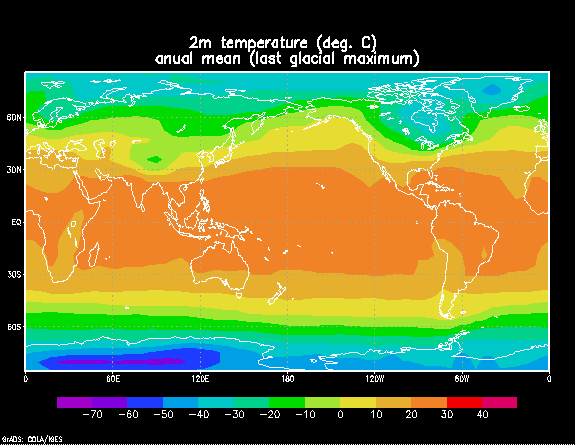
1) The last glacial maximum
The Last Glacial Maximum lasted form approximately 21,000 to 17,000
years ago. During this time was a general cooling of the earth, and
certain aspects of the climate varied from what we know now. The
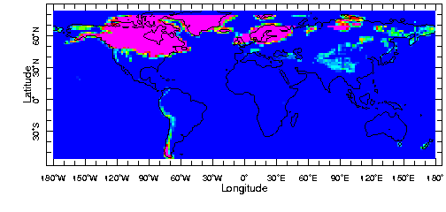
most prominent feature of the Last Glacial Maximum was the ice sheets covering
much of the earth. The three major sheets were the Laurentide Ice
Sheet, the Fennoscadia Ice Sheet and the Cordillerian Ice Sheet.
Although these sheets contained most of the ice on the earth at that time,
there were also smaller ice sheets in Antarctica, Russia and South America.
In order for these ice sheets to be present on the earth, a total of 50
- 60 million cubic kilometers of water was evaporated from the oceans.
This in turn created the sea level to lower by about 125 meters. In addition,
the global temperature dropped by five to six degrees Celsius, thus lowering
the snow line in the mountains by about a kilometer.
The Laurentide Ice Sheet was the largest present during the Last
Glacial Maximum, containing one third to one half of the earth's ice.
It stretched across northern North America, from the Canadian Rockies to
the Atlantic Coast and from the Arctic Ocean to what we now know as the
Mississippi and Ohio Rivers. The Fennoscadia Ice Sheet stretched
over northern Europe and reached to Germany and the Netherlands.
Currently in the Northeast Atlantic, near the Norwegian Sea, the ice in
the water only reaches to about 78(N, but during this glacial period, the
ice cover in the winter reached down to 45(N. The Cordillerian Ice
Sheet covered most of the northwestern United States and stretched all
the way up to Alaska. The Antarctic Ice Sheet was twice the size
we know it today. Due to the decrease in the sea level, the ice was
no longer constrained by the proximity of the ocean.
Just off the borders of the ice sheets were many tundra and polar
desert regions. The areas closest to the ice sheets suffered more
severe winters due to the swift cold wind coming off the glaciers.
Regions still farther away from the glaciers consisted of mainly grasslands
and savannas, which were mostly present in South America and Africa.
This is mainly due to the dryness of the atmosphere, as opposed to the
decrease in temperature.
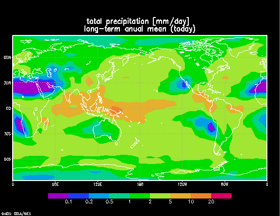
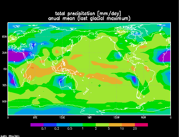
During the Last Glacial Maximum the atmosphere was much more
arid than it is today. The precipitation levels in Greenland and
Antarctica, where the ice cores are drilled, decreased by 50%. Forests
and woodlands were almost non-existent on the earth. The precipitation
levels in the tropical lowlands also decreased by as much as 50%.
The lake levels from the lowlands in Africa and South America provide evidence
that the lakes were 250 - 500 meters lower than they are today. Central
America and the sub-Sahara region were dominated by sand dunes and other
desert-like conditions. The Amazon Rainforest was reduced to localized
regions of higher precipitation, instead of one general area of consistent
heavy rain. This theory is supported by evidence found of localized
woody angiosperms and butterflies found only in these regions.
Due to the decrease in lush forests, the climate was much windier
as well. Since there were no trees and much less foliage to
obstruct the path of the wind, heavy gusts would blow through without interference.
The North Pacific westerly winds increased by 20%, the North Pacific Trade
winds increased by 30%, and the North Atlantic Trade winds increased by
50%. The evidence of the increase in wind comes from an analysis
of the chloride concentrations in the ice cores. Chloride originates
in sea salt. The concentration of the sea salt is dependent upon
the height above the sea level of a particular measuring point and the
speed of the winds. With stronger wind speed, the concentration of
the sea salt increases, thus the concentration of chloride in the ice cores
increases as well.
Very similar to determining the wind speed from the ice cores,
one can look at the level of carbon dioxide and methane in the atmosphere.
When the snow falls on the earth and is compacted by more layers of snow
that fall on top of it, little bubbles get trapped within the snow.
After drilling the ice cores, one can look at the contents of the atmosphere
at a certain period. Atmosphere trapped in the ice cores of this
time period show that the levels of carbon dioxide and methane were much
lower than they are today. One theory to explain this is that the
biological productivity in the ocean increased, so there was more carbon
dioxide in the oceans than in the atmosphere.
Evidence from ice cores also shows that the atmosphere was much
dustier at this time as well. As the temperature decreases, the soil
gets drier, so there is less vegetation on the earth. The only vegetation
that remains is that which can survive dry climates.
It is believed that the Earth began cooling 30,000 years ago due to the Milankovich cycles. This cooling alone could not cool the earth enough to bring about an ice age, but rather these cycles produce changes in the earth's climate which develop into feedbacks which further change the climate. A general circulation model and simulation developed by NASA/GISS shows what the relative temperature drop was from each of many feedbacks.

The first bar shows a 2.2(C temperature drop due to water vapor
and clouds. As the atmosphere first began to cool slightly, the air
began to cool as well. Since colder air cannot hold as much water
vapor, the water vapor content of the atmosphere decreases as well.
Since water vapor acts as a greenhouse gas, the atmosphere begins to cool
further. In addition, since the air cannot hold as much water vapor,
it must be held on the earth, and due to the colder temperatures, it may
be frozen into the ice sheets. This in turn will provide more ice
on the earth, raising the earth's albedo, which increases the amount
of radiation emitted back into space, which again cools the earth.
A thick layer of clouds will cause more radiation from the sun to be reflected
back to space even before it hits the earth which will also cool the atmosphere.
Land and sea ice together cause a projected cooling of about
1.6(C. This will cool the atmosphere by the ice-albedo feedback as
mentioned above, and will also cool the earth by conduction. Ice
on the surface of the earth will cool the air close to it because the ice
itself is very cold.
The vegetation, or lack there of will cause the earth to cool
by approximately 0.3(C. Since lush, green forests are generally darker
than desert sand, this could also affect the albedo of the earth.
The brighter conditions of drier weather may increase the albedo, thus
cooling the earth due to the ice-albedo feedback. In addition, due
to the decrease in the amount of vegetation present on the earth, there
is less carbon dioxide output by plants, and since carbon dioxide is a
greenhouse gas, this would also produce a cooling affect. This leads
into the carbon dioxide bar on the graph, which produces a 0.6(C cooling
of the earth's atmosphere. This ties into the vegetation decrease
and the increase in biological productivity as mentioned earlier.
The last bar on the graph shows the amount of cooling due to
the orbital variations, or the Milankovich cycles. As one can see,
this is much smaller than any of the other feedbacks mentioned. This
is because the orbital variations only began the cooling, which in turn
affected the feedback cycles of those mentioned above. Only
a little variance can cause a large affect on the atmosphere of the earth.