Contrasting views of climate: 'static' versus 'dynamic' were discussed. In the former one thinks of climate as having changed in the past, but as unchanging on the time scale of human events, whereas in the latter, one views the climate as continually changing, on all time scales. Thirty years ago, we tended to think of climate as static, but now we appreciate that it varies on a range of time scales. Two specific examples: El Nino causes climate to vary from one year to the next and greenhouse warming could make the climate of the 21st century different from what we have experienced in the past.
Similar distinctions arise in other walks of life.
Wallace offered the example of a baseball team. A blow-by-blow description
of who did what in what inning of what game is like the weather; a tabulation
of the wins and losses, hits, runs batted in, etc during the past season
or the past dacade is like the climate. Like the climate, the fortynes
of a baseball team can change from year to year, and sometimes it os possible
to predict that a team will do better or worse next year than they did
last year because, for example, they just recruited (or lost) a superstar
pitcher. Members of the class suggested that analogous distinctions
arise in business and politics.
![]() back
to AtmS 211
back
to AtmS 211
Table 1: Equivalent blackbody temperature TE of some of the planets
| Planet | Distance from sun
(in units of 106 km) |
Albedo | TE |
| Mercury
Venus Earth Mars Jupiter |
58
108 150 228 778 |
0.06
0.78 0.3 0.7 0.45 |
442
227 255 216 105 |
We spent some time examining a map of annual mean surface air temperature
over the globe. [to
view an improved version of the picture that we examined in class, click
here.] Temperatures range from near 30 C in the tropics to below
zero in the polar regions. In the tropics, the western Pacific and
Indian oceans are a degree or two warmer than the eastern Pacific and Atlantic
oceans. The Himalayas and Tibet show up as a cold spot. Some
other more subtle features were pointed out that will show up more clearly
when we examine data for summer and winter next week. Students needed a
bit of coaching to get them to just describe the pattern, rather than trying
to interpret it. In science, as in good detective work, it's important
to do a careful description first: to get all the facts on the table before
proposing theories to explain them.
2.2 Composition
The composition of the atmosphere was discussed. Most of the
mass of the atmosphere is made up of nitrogen (a largely inert gas) and
oxygen, both in the form of molecular species with two atoms. For
reasons that will become apparent later on molecular species with three
atoms, even in trace amounts, are essential in making Earth a livable planet.
The most important of these are water vapor, ozone and carbon dioxide.
Table 2: Composition of the earth's atmosphere below 100 km
| Constituent | Molecular weight | Content
(fraction of total molecules) |
| Nitrogen (N2) | 28.016 | 0.7808 (75.51% by mass) |
| Oxygen (O2) | 32.00 | 0.2095 (23.14% by mass) |
| Argon (A) | 39.94 | 0.0093 (1.28% by mass) |
| Water vapour (H2O) | 18.02 | 0-0.04 |
| Carbon dioxide (CO2) | 44.01 | 325 parts per million |
| Neon (Ne) | 20.18 | 18 parts per million |
| Helium (He) | 4.00 | 5 parts per million |
| Krypton (Kr) | 83.7 | 1 parts per million |
| Hydrogen (H) | 2.02 | 0.5 parts per million |
| Ozone (O3) | 48.00 | 0-12 parts per million |
Water vapor is the atmospheric component of the hydrologic cycle.
The table below shows the inventory of water on Earth. Most of it
is in the oceans and in the continental ice sheets (Antarctica and Greenland).
Only a tiny fraction of it is in the form of water vapor in the atmosphere.
Table 3: an inventory of the hydrosphere
| Component | Percentage of mass of hydrosphre |
| Oceans
Fresh water (underground) Fresh water in lakes, rivers, etc. Atmosphere |
97.0
2.4 0.6 0.02 |
![]() back
to AtmS 211
back
to AtmS 211
We made a distinction between the homosphere (the well mixed layer below 100 km) and the heterosphere (the thin outer atmosphere in which the heavier molecular species like O2 and N2 give way to lighter species as one ascends). We found that the notion of a well mixed lower atmosphere runs counter to most students' intuition, which is probably based on their experience with liquids, in which the molecules are not as mobile as they are in gases. We will discuss this further in section 3.1.3
The other important distinction is between troposphere, which extends from the surface up to about the cruising level for jet aircraft and the stratosphere which extends from there upward to the 50 km (30 miles) level. The stratosphere is the site of the ozone layer and it serves as a reservoir for certain long lived pollutants.
Temperature decreases with height in the troposphere at a rate of about 3.5 F per thousand feet. On the basis of this relationship, one would expect Snoqualmie Pass, at an altitude of 3000 ft to be about 10 F colder than Seattle and the top of the ski lift at Alpental, at 6000 ft to be 20 degrees colder. Any skier knows from experience that this climatological 'rule of thumb' doesn't always work. There are days when Snoqualmie Pass is warmer than Seattle and temperatures get warmer as one ascends the ski lift. These reversals of the ordinary layering of temperature are called inversions, and they often occur in association with air pollution episodes in the Puget Sound region. Clouds form readily in the troposphere, where there is plenty of water vapor available to condense in rising currents of air (updrafts). Growing raindrops and snowflakes cleanse or 'scavenge' dust and smoke particles from the air, keeping it clean. Hence, the 'residence time' for many tropospheric pollutants is comparable to the residence time for water vapor...i.e., a week or so.
Temperatures in the stratosphere tend to increase
with height (as in inversions within the troposphere). Under these
conditions, vertical mixing of air tends to be inhibited. Because
of the weak vertical mixing, air parcels that find their way into the stratosphere
tend to remain there for a long time; i.e., they have a long 'residence
time' in the stratosphere. Buoyant updrafts of tropospheric air are
unable to penetrate very far into the stratosphere and so clouds are observed
there only under very special conditions. Particles that are injected
into the stratosphere (e.g., by strong volcanic eruptions or nuclear tests)
tend to remain there for a long time. There are no raindrops to scavenge
them and it may be months or even years before they find their way into
the troposphere.
![]() back
to AtmS 211
back
to AtmS 211
We have a number of N measurements of variable x (e.g. temperature, precipitation, )
Mean: ![]()
Standard deviation: ![]()
The standard deviation is a measure of how much the individual measurements deviate from the mean.
Climate varaibles like temperature will vary over the course of a day with high temperatures in the afternoon and low temperatures at night. It is therefore useful to know the mean daily temperature (Tmean) as well as the maximum (Tmax) and minimum (Tmin) temperature that occur in the course of a day. Those temperatures are in turn often integrated over a month, so that you can have a mean, maximum or minimum average temperature for January, February
For example: ![]() ,
which is divided by 31, because january has 31 days.
,
which is divided by 31, because january has 31 days.
All climate data are in addition averaged over a number of years, the period of record. So if you look up the minimum temperature for January on the web, you will actually find a double mean:
![]()
Unfortunately, the overbars are mostly omitted in the tabular data.
Some of the tables also give the highest daily temperature ever measured, or the highest monthly mean, that ever occurred.
![]() back
to AtmS 211
back
to AtmS 211
2.5 Clouds and rainfall
Three kinds of satellite imagery will be shown in the lecture: visible,
infrared and microwave:
Visible imagery (below) shows clouds they would appear to the naked eye.
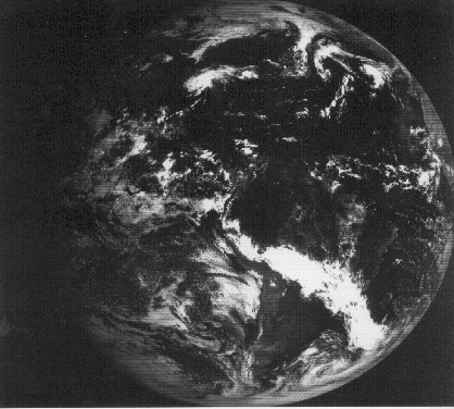
Infrared imagery (below) shows the 'radiation temperature' of the cloud tops. It is helpful in distinguishing between high clouds, which have cold tops, and low clouds whose tops are not much colder than the earth's surface, which shows through in the cloud-free areas.
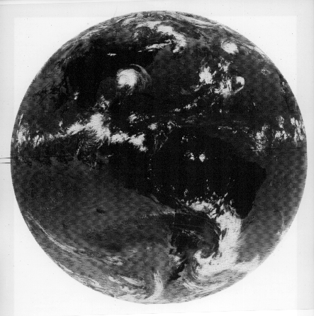
Microwave imagery is like radar: it picks up the areas where it is actually raining (as opposed to just cloudy) and can be used to estimate actual rainfall amounts.
Among the features that emerge are:
- the cloud free subtropical deserts of which the Sahara is only a small part. You may be surprised to discover that much of the equatorial Pacific lies within a vast desert region.
- the intertropical convergence zone (ITCZ): a remarkably thin east-west band of clouds and heavy rain over the tropical oceans. The ITCZ lies not on the equator, but usually about 7 degrees of latitude to the north of it.
- the monsoons: more diffuse belts of heavy, intermittent rains over the tropical continents in the summer hemisphere. The Indian monsoon is the most famous, but you'll see similar features over the other continents as well. During July and August the "North American monsoon" extends as far north as Arizona. Monsoon rainfall exhibits some interesting variations with time of day: in some areas it rains mostly during the afternoon and evening; in others it rains mainly during the morning hours.
- the extratropical (outside the tropics) 'storm tracks': at higher latitudes much of the rainfall is organized in the form of migrating 'extratropical cyclones' which move along preferred tracks, usually from west to east. Seattle, with its notoriously rainy climate lies along the downstream end of the pacific storm track, where disturbances are decaying.
- tropical cyclones tend to be smaller in horizontal scale, but much more intense than their extratropical counterparts. They tend to form in preferred regions and move along preferred tracks.
- the subtropical stratus decks: Not all clouds bring rain. Some of the driest areas on earth tend to be cloudy, day after day like some of the more dreary autumn mornings in Seattle. The satellite imagery reveals where these regions are located.
![]() back
to AtmS 211
back
to AtmS 211
The distribution of surface winds over the earth is complicated, but the broad outlines of it can be understood in terms of a few simple concepts:
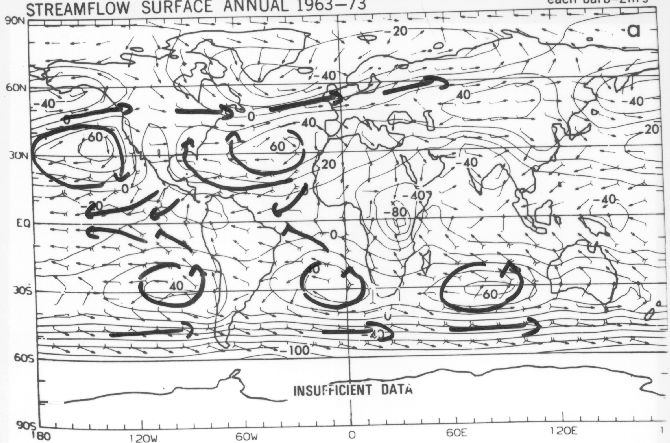
- the tradewinds over the tropical Pacific and Atlantic, which blow from the northeast in the Northern Hemisphere and from the southeast in the Southern Hemisphere. The Southeast Trades cross the equator and meet the Northeast Trades around 7 N in the Intertropical Convergence Zone (ITCZ). The converging currents of air ascend where they meet, fueling the heaviest and most persistent rain belt on Earth, which is only 100-200 miles wide. The tradewinds typically blow year-round with velocities of 10-25 knots.
- the westerlies which prevail poleward of 30 degrees latitude in both hemospheres. The winds in the westerly belt are not as steady as the tradewinds: they often reverse directions from one day to the next. They often blow in excess of 30 kts in the 'roaring forties' (~40-60 S) and they can sometimes be quite strong over the North Pacific and North Atlantic during wintertime.
Between the westerly belts and the tradewinds (near 30 degrees latitude) lie the subtropical anticyclones, vast regions of clockwise flow in the Northern Hemisphere and counterclockwise flow in the Southern Hemisphere. (A cyclone is a circulation in the same sense as the earth's rotation as viewed from above looking down on the pole in the appropriate hemisphere, and an anticyclone is just the opposite). The flow over the Gulf of Alaska and the far north Atlantic is counterclockwise turning (cyclonic).
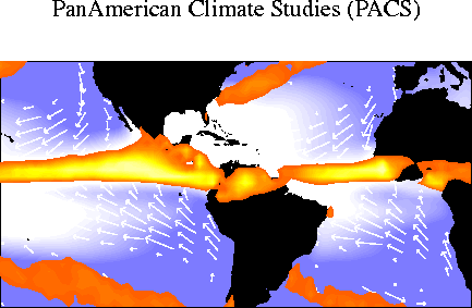
We examined a map of ocean color as viewed by satellite.
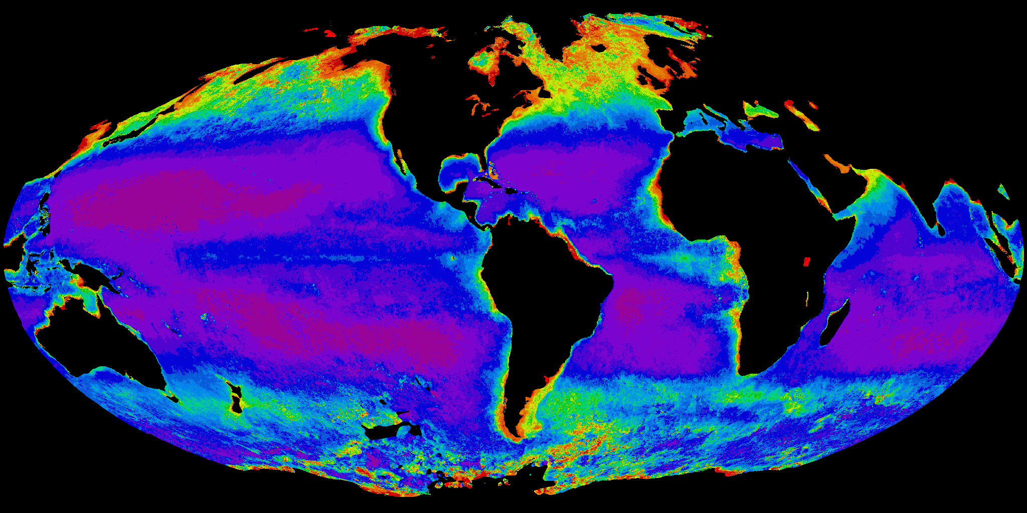
To make the subtle gradations in color
more clearly visible, the color scale has been stretched so that the greenest
waters are rendered in warm colors and the least green in violet and dark
blue. The warm colors correspond to regions with high chlorophyll
content due to the presence of plankton blooms, which have a life cycle
lasting only a day or so. The plankton feed upon and rapidly consume
nutrients are brought up into the sunlit waters near the ocean surface
by upwelling currents. Hence, the warmer colors in the image indicate regions
where upwelling is taking place. They also correspond to regions
of productive fisheries, since the plankton that show up in the image are
the bottom rung in the 'food ladder' that feeds the larger fish.
There are patches of warm colors along many of the coastlines but especially prominent are the ones along the Peru coast and the analogous Atlantic coasts of Africa, both north and south of the equator. The open waters Gulf of Alaska and the far North Atlantic have relatively warm colors, and there's a strip along the equator that is conspicuously green. The least productive areas lie along 30 degrees latitude.
Many of the features in the distribution of ocean color can be explained on the basis of the surface winds but in order to understand the relationship it is necessary to learn a little bit about how the wind affects the ocean on a rotating planet. In agreement with what might think intuitively, the surface wind tends to drag the surface waters along with it, creating currents that flow in the same general direction as the surface winds. They assume the form of closed circulations gyres beneath (and circulating in the same sense as) the subtropical anticyclones. The tradewinds drive cool equatorward currents along the coasts of Peru and California and analogous regions of the African coast. The Coriolis Force due to the earth's rotation tends to deflect (or turn) the ocean currents toward the right in the Northern Hemisphere and toward the left in the Southern Hemisphere. As the surface waters are driven away from the Peru and California coasts by the Coriolis Force, water from below rises to the surface to take their place, bringing nutrients with it to feed the food chain. Hence the warm colors (greenness) in the satellite image. The opposite occurs within the gyres beneath the subtropical anticyclones: the Coriolis Force drives the water inward toward the centers of the gyres, forcing it to downwell rather than upwell. Downwelling prevents nutrients from coming up to the surface to feed the food chain: hence these regions show up purple in the image from the color scanner: purple implies an absence of green chlorophyll, which marks these regions as biological deserts.
Seasonal Variations in Climate
Except for the inner tropics, within 10-15 degrees of the equator, virtually all locations on earth experience a warm season that peaks 4-5 weeks after the summer solstice (June 21 in the Northern Hemisphere, plus or minus a day or two) and a cold season that peaks 4-5 weeks after the winter solstice. The contrast between warm and cold seasons increases markedly with latitude and it tends to be larger over the continents than over the oceans, and larger over the interior of the continents than over coastal regions. Over oceans and some coastal regions the peak of the warm and cold seasons lag by as much as 7-8 weeks behind the solstices so that August is usually warmer than July and February colder than January. We saw this in the group presentation that described the climate of eastern Canada. Over parts of the tropical oceans there are some strange patterns of seasonal temperature variation. For example the eastern equatorial Pacific Ocean experiences its warmest temperatures in March and its coldest temperatures in September.
Rainfall exhibits a wider variety of patterns
of seasonal variation than temperature does. Over the tropical continents,
the 'annual march' of rainfall (as it is called) is dominated by the monsoons,
which move back and forth across the equator with the seasons as illustrated
by the imagery at http://tao.atmos.washington.edu/legates_msu/.
The rain belts are wide enough so that many of the equatorial regions like
the Amazon, the Congo, and Indonesia remain within them and experience
ample rainfall amounts year round. But as one moves away from the
equator one begins to encounter a winter 'dry season' that becomes more
and more pronounced (i.e., longer and more completely rain-free) as one
approaches the subtropics. These monsoon climates dominate continental
climates between 5 and 20 degrees latitude.
The edges of these tropical rain belts don't
penetrate much beyond 20 degrees latitude, leaving the subtropics dry year
round. The 'North American Monsoon' brings an increase in relative
humidity and widely scattered thunderstorms as far north as Arizona and
New Mexico, where the rains often start abruptly around the first of July
[LINK TO GROUP 8]. It is interesting to note that northeast Brazil
and the region surrounding it does not fit the classical monsoon model:
this equatorial region experiences receives most of its rainfall during
March, April and May, as illustrated in the presentation of Group
7 .
The intertropical convergence zones over the Pacific and Atlantic Oceans also move northward and southward with the seasons, but they remain north of the equator year round.
In the extratropics, the most notable contrasts in the annual march of rainfall are between western Europe and the United States to the west of the Rockies, which tend to be dry during the summer [LINK TO GROUP 6] and eastern United States and east Asia, which experience humid summer climates with thunderstorms in some areas. For example, summer flooding this year caused a great amount of misery in China. These contrasts can be explained in terms of the subtropical oceanic anticyclones, which dominate the summer climates of these regions. [LINK TO FIGURE]. California and Spain lie in similar positions relative to the Pacific and Atlantic anticyclones. Both experience dry, northerly winds. Shanghai, Tokyo, and Washington DC, on the other hand, lie to the west of these anticyclones where the prevailing winds are from the south, bringing warm, humid air over the continent.
![]() back
to AtmS 211
back
to AtmS 211
The following, which was used as a basis for this lecture, was adapted, with only minor mosifications from the introductory Atmospheric Sciences textbook by S.D. Gedzelman "The Science and Wonders of the Atmosphere", published by John Wiley.
The climate of a region is its average weather. The two most important
variables of climate are temperature and precipitation, while others such
as cloudiness, fog, humidity, and wind are also important.
Seasonal variations must also be included in any account of climate.
If we merely used annual averages to define the climate we might think
that San Francisco and Beijing, have very similar climates. San Francisco
has an annual temperature and precipitation of 13 C and 51 cm, respectively,
while Beijing has 12 C and 61 cm, respectively.
However, there are a few "minor" differences between these climates.
In July, when the average temperature in San Francisco is 15 C, Beijing
swelters at 27 C. Furthermore, July is the middle of the long dry season
in San Francisco, but it is the heart of the rainy season in Beijing. In
January, it is bone chilling (-4 C) and bone dry in Beijing, whereas San
Francisco is pleasantly cool (10 C) and in the middle of its rainy
season. Finally, San Francisc known for its frequent fog, while the dry
air in Beijing winter months is filled with dust (loess) from the Gobi
Desert.
In many places the weather varies considerably from year to year so that it is necessary to choose some standard averaging period. This is usually chosen to be 30 years, a long enough period to permit the year-to-year variations to average out and short enough that distinct climatic trends can be spotted by comparing different 30-year periods.
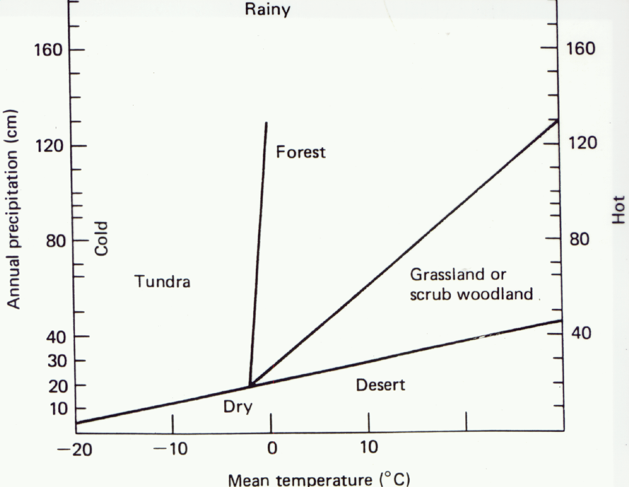
Vladimir Koeppen, the great climatologist, devised the first modern climate classification scheme in 1900. In it he documented the amazingly close connection between climate and plant life. In fact, his scheme is based largely on the world patterns of plant life, and many of the climate regions are named after the dominant vegetation of the region.
Basically, there are five types of botanical regions: forests, grassland, desert, tundra, and ice cap.
Ice-cap climates are found wherever the average temperature of the warmest month is below O C. Tundra vegetation dominates when the temperature of the warmest month is between 0 and 10 C. Once the temperature of the warmest months reaches 10 C or more, forests form, provided there is adequate moisture. Usually this means adequate precipitation, but trees also grow in deserts along the riverbanks and in oases.
The amount of precipitation necessary to support forests depends on the temperature of the region, since evaporation rates tend to increase with increasing temperature. Therefore, in the tropics the precipitation must be at least 125 cm annually to support forests, while the great boreal forests of Canada and Siberia can survive on 25 cm or less annually.
When the annual precipitation falls below a certain critical value, grasslands replace the forests. Isolated trees may grow, but these are often stunted. As the precipitation drops still lower, even the grasses cannot survive, and desert vegetation takes over.
There are several other climate-vegetation relationships that are important. Tropical vegetation grows if the monthly average temperature remains at least 18 C. Subtropical vegetation usually grows in regions where at least 8 months of the year have a temperature of at least 10 C. Thus, San Francisco is classified as subtropical under this criterion, even though you need to wear sweaters most days of the year.
In this book I use the climate classification scheme developed by Glenn Trewartha which is a variant of Koeppen's scheme. The climate map of the world is shown with a brief legend to define each region.
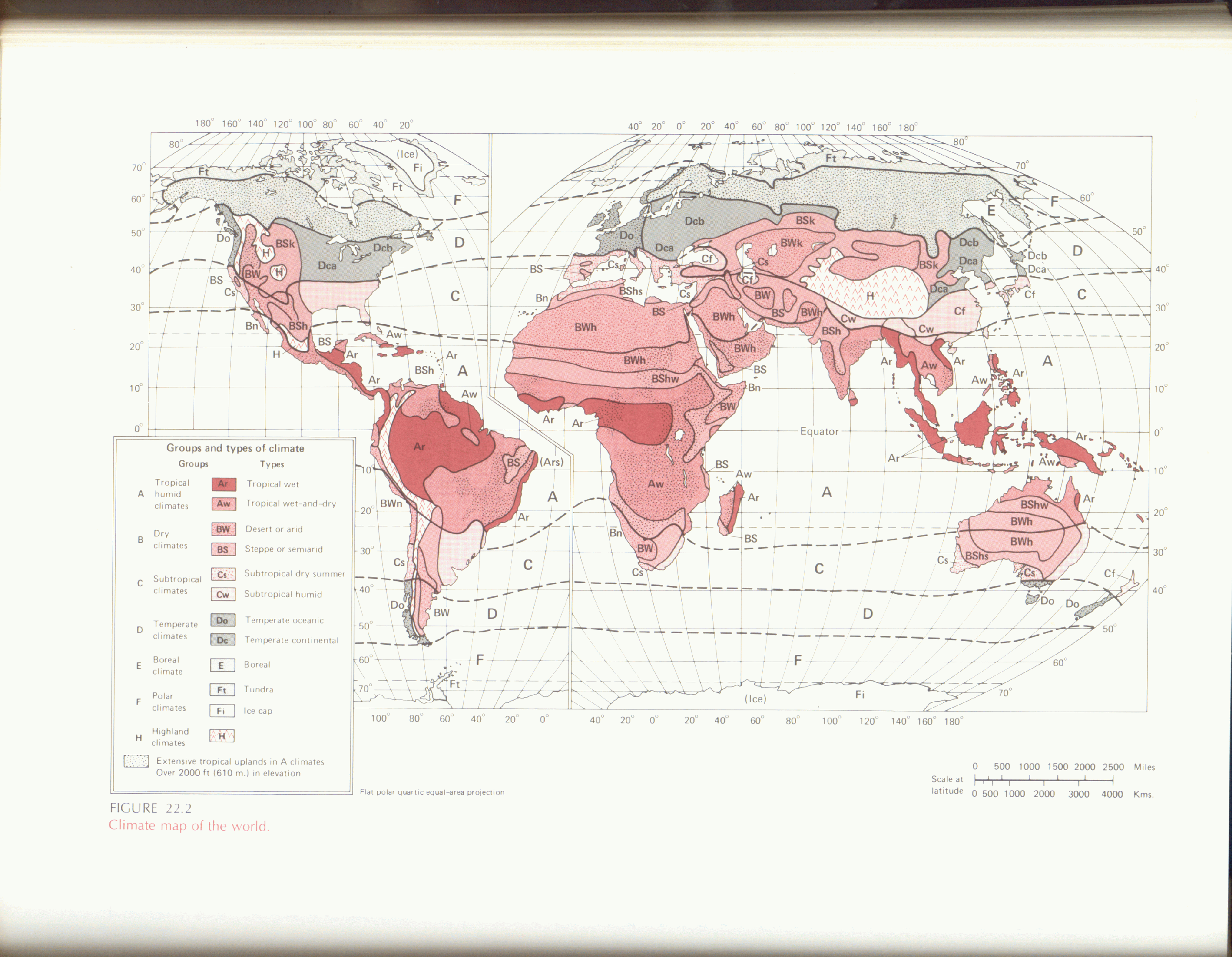
Briefly, A climates are tropical climates with all months at least 18 C, C climates are subtropical with 8 or more months at least 10 C, D climates are temperate with 4 to 7 months at least 10 C, E climates are subpolar or boreal forest with 1 to 3 months at least 1 C, and F climates are polar (tundra or ice cap) with no months reaching 10 C. The B climates are the arid or semiarid climates in which the evaporation exceeds the precipitation, whereas H climates are the highland climates that vary sharply with altitude.
In the discussion that follows I freely use the letter symbols when describing the climates. Therefore, you will need to refer to this section to understand what is going on.
Most of the difficulty in memorizing the world's climate is due to the irregularities of the world's geography. Therefore, it is instructive to draw an "ideal continent" (i.e., one without irregularities) and then imagine what its climate patterns would be. Then, every time you looked at the climate of the real world and found that a particular region did not match the ideal picture you could immediately say, "This region has an anomalous climate because of a geographical irregularity."
The ideal continent described runs from pole to pole and is bounded on the east and west by lines of longitude (and, of course, oceans). Since the continent is symmetrical around the equator, we need treat only the climate of one hemisphere, the other being a mirror image.
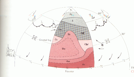
Rainy tropics (designated Ar) extend in a band from the equator to 5 or 10 degrees latitude, due to the more or less constan presence of the ITCZ (loosely defined over land/. The Ar climates will extend farther poleward on the eastern side of the continent because of the tropical easterlies (which blow upslope on the east coast), while on the western shore the Ar climate will be somewhat restricted.
In this band we find the tropical rain forest or jungle. Here temperatures remain almost constant year round and average about 26 or 27C. The only significant temperature variations occur between day and night in this land of perpetual summer.
Proceeding poleward, we next encounter the wet and dry tropics (Aw). This climate is so named because it has one dry season and one rainy season each year. The rainy season occurs when the ITCZ wanders north of the equator around July. The rest of the time the ITCZ is too far south to affect the region, and sinking air from the subtropics dominates. The farther poleward you move, the shorter the rainy season and the drier the climate becomes. Here there are significant monthly variations in temperature with the coldest month invariably January (in the NH) and the warmest month generally the one just prior to the onset of the rains.
The Aw climate grades to semiarid (BS) and then finally to desert (BW) from about 20 to 30 deg. latitude in the center and at the western shore of the continent. The vegetation changes accordingly from forest to savannah-type grass-land to desert.
The large subtropical highs centered at about 30 deg.latitude over the oceans play a very important role in the climate of the regions from about 15 to 45 deg.latitude, but they bring completely different weather to the eastern and western coasts of the continents. On the western side of the continent the high brings very dry, stable weather that is hot inland, but cool and foggy along the coast because of upwelling. On the eastern side of the continent the high brings warm but humid weather, with plentiful rain fro showers and occasional hurricanes.
During the winter season the subtropical highs weaken and drift toward the equator. The influence of the westerlies is felt increasingly from about 25 deg. latitude poleward. The westerlies bring passing lows and rain to both coasts. On the west coast the temperatures generally remain mild for the given latitude because of the oceanic influence, but on the eastern side of the continent the westerlies help draw in cold continental polar air from the interior of the continent.
Above about 40 degrees latitude the influence of the subtropical high weakens even during the summer, permitting the west coast to have some summer precipitation and allowing the eastern side of the continent some relief from the heat. During the winter the westerlies dominate almost completely, bringing oceanic air constantly against the west coast and one cold wave after another to the eastern side of the continent.
As a result of these influences the west coast has a dry summer, subtropical climate (Cs) between about 30 and 40 deg. latitude. The long dry season makes it impossible for forests to survive, except perhaps along the foggy coast or in the mountains. Then from about 40 to 60 deg.latitude the west coast has a temperate oceanic climate (Do) with cool pleasant summers, but relatively mild and very, very cloudy, wet winters.
The eastern side of the continent has a humid subtropical climate (Cf) between about 25 and 35 deg.latitude. This has adequate moisture at all seasons, with an unpleasantly hot, humid summer. This climate grades into the temperate continental (Dc) climate above about 35 deg. latitude. The Dc climate persists up to 45 or 50 deg.latitude and, while its summers are more tolerable than those of the Cf climate, its winters are dramatically colder, with snow more likely than rain during the winter above about 40 deg. latitude.
If the continent is sufficiently wide, then the center will tend to be semiarid or arid because of the remoteness of a moisture source. This is true especially on the lee or downwind side of any mountain ranges.
From 50 to about 65 latitude, the boreal forests gird the continent. The boreal climate (E), named after this vegetation type, has pleasant summers and frigid winters, and one outstanding feature of this climate is the large annual variation of temperature. Naturally, the boreal forest is located farther poleward on the warm, western coast.
Tundra (Ft) should be found above about 65 deg. latitude and this region will eventually give way to an ice-cap climate (Fi). The ice-cap climate might take over about 75 deg. latitude, but perhaps somewhat farther south along the coasts that have a large moisture supply.
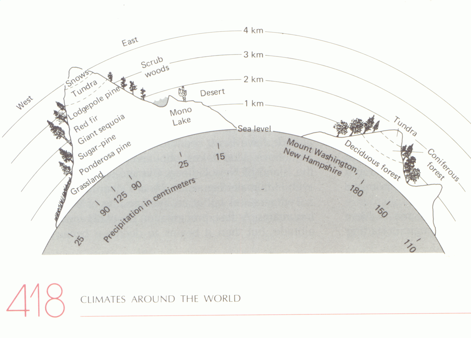
Climate and Elevation:
![]() back
to AtmS 211
back
to AtmS 211
The last two lectures on climate types and climate and land forms were demonstrations of scientific information that is inherently qualitative. It involves careful observation and interpretation. The group projects involve the same kind of activity. But to answer certain kinds of questions about climate, qualitative reasoning is insufficient. For example, if we want to explain why the current average temperature at the earth's surface is 60 F rather than 80 F, or if we want to predict how much it is likely to increase as a result of the doubling of the concentrations of greenhouse gases in the atmosphere, we have to be able to make quantitative inferences as well.
In order to understand what determines the temperature of the Earth we need to understand something about the branch of science called thermodynamics, which is inherent in both physics and chemistry. Much of thermodynamics can be expressed in terms of two laws. The first, in effect, tells us that, in terms of energy, we can't get something for nothing and the second tells us that we can't even break even (i.e., that it's impossible to build a perpetual motion machine). We will be mainly concerned with the First Law can be expressed in the form of two statements:
______________________________
1. Apart from thermonuclear reactions (which
won't be considered here), the total energy of a closed system is conserved,
where
- a "system" is defined as a prescribed object or set of objects (e.g., the Earth, the atmosphere, a person...) and a "closed system" is a system that does not exchange energy with its environment,
- the total energy is the sum of the internal
energy of the molecules (thermal and chemical and that related to phase
changes between solid, liquid and gas); potential (for our purposes mostly
related to the position of the system in the gravitational field), and
kinetic or mechanical energy (related to the organized motion of the molecules,
as in wind).
2. Open systems gain total energy at the expense of the rest of the universe and vice versa.
______________________________
3.1.1 Basic concepts
The conservation of energy is one of several conservation laws that are used in the sciences. Another commonly used conservation law is the conservation of mass. An analogous (but not necessarily true) conservation statement in the social sciences would be
1) the total wealth of a closed society is conserved
-where a society is an individual or an aggregate of individuals like a family, a corporation, or a nation and a closed society is one that doesn't exchange total wealth with its neighbors / competitors, and
- total wealth is the sum of currency plus possesions can be valued in currency and traded;
2) Societies that trade gain wealth at the expense of their neighbors / competitors and vice versa.
To talk about energy in a quantitative way, we have to be able to express it in some kinds of units analogous to 1994 $ U.S. in the social science analogy. We also need a unit for the rate of generation, consumption or exchange of energy called "power", analogous to hourly wage, monthly salary, or annual income (i.e., like "earning power").
For energy units we will use the Joules, and the
more familiar kilowatt-hour (kwh); and for power, the watt (W) which is,
by definition, 1 joule per second (1 J/s), and the more familiar horsepower
(hp), where 1 hp = 2544 W. By definition, 1 kwh = 1,000 J/s x 60
m per hr x 60 s per min = 3.6 million J. Hence, the standard horse
would put out 2544 x 60 x 60 J, or nearly 10 million joules in an hour
(if it could operate at full power that long without collapsing) and a
high perfrmance sports car engine would put out half a billion joules.
(Like the ruble or the yen, the joule is a smaller unit than the ones we're
accustomed to dealing with.)
Now let's consider the following problem: A 220 lb (100 kg hiker climbs a 1 km mountain (comparable to Mt. Si) in an hour. How much energy does he have to expend in order to climb this far against the force of gravity, and how hard does he work?
We can solve this problem by calculating the increase in the gravitational potential energy of the hiker during the course of climb, which is given by [the downward force of gravity times the distance he climbs], which is equivalent to [the hiker's mass times the gravitational acceleration times the distance he climbs] or, in numerical values [100 kg x 9.8 meters per sec per sec x 1000 m] which works out to just short of 1 million joules. To incraese his potential energy by 1 million Joules in an hour (3,600 s) [i.e., 1 million J per divided by 3600 seconds] which is equivalent to 277 W or sloightly more than a tenth of a horsepower.
Now let us relate the energy expended by the hiker to the number of calories of food 'burned' off in the process. One dietary calorie, when burned releases an amount of energy equivalent to about 4,000 J. Dividing the million joules of potential energy by 4,000, we obtain 250 calories, the amount in a candy bar. However, this is only a small part of the energy expended by the hiker in climbing the mountain. An efficient hiker has an efficiency of 20%, which means that he/she has to expend about five energy units in order to perform 1 energy unit's worth of work. So the number of calories 'burned off' by the hiker is more like 1250 or about 1/3 of his typical dietary intake.
What happens to the 1000 dietary calories (4 million joules) that don't end up as potental energy? They're eliminated as waste heat. We can confirm this is true by considering the hiker's water consumption and assuming that this is equivaent to the amount that his body perspired in order to cool itself by evaporation. A reasobable estimate for his water consumption might be 1 liter, which is equivalent to 1 kg. The amount of waste heat used up in evaporating 1 kg of water is 2.5 million joules, which accounts for most of the heat rejected by the hiker. If the weather is cool, it will be easier for the hiker to reject heat than if it is hot and he will be able to climb faster.
The above problem is an example of energy conversion. Chemical energy has been converted to mechanical energy by the hiker's body and by walking uphill, the hiker has converted mechanical energy into gravitational energy. Here is another example. Imagine a tank filled with equal volumes of liquids of differing densities like oil and water, separated by a rigid vertical partition. The partition is abruptly removed and the denser fluid sinks beneath the lighter fluid. The fluids slosh back and forth in the tank for a while, but because of friction, the motion quickly comes to a stop, with the denser gluid occupying the bottom halk of the tank and the lighter fluid on top. And now the question. For a while the fluid had kinetic energy. Where did it come from? Think about this question before you read on and see if you can answer it for yourself.
Before the partition is removed, the center of mass of the fluids in the tank is exactly halfway up to the top of the fluids. Half the mass is above that level and half is below it. After the fluids have come to rest again, the centrt of mass must be somewhat below the midpoint of the tank because the denser fluid, which accouns for more than half the mass now occupies the bottom half of the tank and its center of mass is one quarter of the way up from the bottom. Since the center of mass of the fluids has dropped, it follows that the potential energy has decreased. This release of potental energy is the source of the kinetic energy. But where did the kinetic energy go when the motions stopped? Friction converted the organized fluid motions into random molecular motions: i.e., kinetic energy into internal energy, which is reflected in a higher temperature of the fluid. The temperature change is so small that elaborate instrumentation would be required in order to detect it. Hence, in this scenario, potental energy is converted to kinetic energy which, in turn, is converted into internal energy.
Now let us consider a problem involving an application of the First Law of Thermodynamics to an open system. How much energy is required to raise the temperature of 1 kg of water from room temperature 20 C to the boiling point (100 C)?
To solve this problem it is necessary to know how mich energy is required to raise the temperature of 1 kg of water by 1 C. This amount, which has been established on the basis of laboratory experiments, is 4218 J (we'll round it off to 4000). This quantity is called the "specific heat" of water. It's a measure of the heat capacity of the substance. Strictly speaking, it depends upon the temperature of the water, but that dependence is so small that it is usually ignored, so that makes our calculation very simple. The required energy is simply [(100 - 20) degrees C x 4000], or 320,000 J. If we have a 1,000 W electric kettle, the time required to heat the water is [320,000 watts divided by 1000 watts per second] or 320 seconds. The energy consumed is [1 kw per second x 320 seconds divided by 3600 sec per hour] or slightly less than a tenth of a kwh]. Hence the cost as today's Seattle electric rates ($.05 per kwh) is far less than a penny.
Now let's perform a similar calculation for air.
Let's calculate how much energy would be required to heat the air in the
classroom from 0 C to 20 C. First we need to estimate how many kg of air
are in the room. To do this we estimate the volume of the room and
multiply it by the density of air at sea level (1.25 kg per cubic meter).
Let's assume horizontal dimensions of 10 m by 10 m and a height of 3 m,
so we have a colume of 300 cubic meters and a mass of [1.25 x 300] or 375
kg. which we'll round upward to 400. The specific heat of air is
1000 J per kg per deg. C, only 1/4 that of water.
Hence, the energy required to heat the room is
[400 x 1000 x 20] or 8 million joules or slightly more than 2 kwh.
The students were given a problem to think about
over the weekend. Consider two identical houses that are both heated with
electricity. One has resistors (heating elements that get hot due
to the electricity flowing through them-- no moving parts) and the other
has a 'heat pump; with a compressor, heat exchangers, fans] etc.
The home with the heat pump uses only about half as much electricity as
the other home. Is the owner violating the First Law of Thermodynamics
and getting something for nothing? Hint: to answer this question,
you need to know a little bit about how heat pumps operate (they're a lot
like air conditioners). In particular, you need to think about the
part of the heat pump that is outside the house.
![]() back
to AtmS 211
back
to AtmS 211