Welcome to the
Last 100 million years!
Group B Members:
Michele Burns, Brett Carp,
Judy Hope, Melissa Hutchens, Myer Hutchinson, Shane Kimura, Alissa Odell,
Alaina Walker
***Link
to Class webpage***
Outline:
Continental
Drift and Plate Tectonics
Alfred
Wegener and Pangaea
How
the atmosphere was affected
Mountain
Forming
Continental
Drift and Plate Tectonics
Plate tectonics (plate structure)
is a coherent theory of massive crustal rearrangement based on the movement
of continent-sized lithospheric plates, developed in the 1960's.
Earth's crust, the outermost
shell, is made of a broad mixture of rock types which solidified billions
of years ago, soon after the earth formed. It is not a solid "shell", it
is broken up into huge, thick plates that drift atop the soft, underlying
mantle.
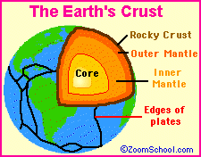
There are two kinds of crusts.
The first is continental crust, which lies above the water. The second
is oceanic. Oceanic crust is more active than continental, but it is thinner.
The current continental and oceanic plates include: North American plate,
Juan de Fuca plate, Cocos plate, Pacific plate, Carribean plate, Nazca
plate, Scotia plate, South American plate, African plate, Antarctic plate,
Arabian plate, Eurasian plate, Indo-Australian plate, Fiji plate, Caroline
plate, and the Philippine plate. There are also smaller plates within these
major plates.
Plates drift about the globe
at about 1 to 10 cm per year, and over long periods of time, they change
in size and shape. They may be added to, crushed together, or pushed back
into the mantle. Plates can be 50-250 miles thick. Sea levels also changes
over time, exposing more or less crust.
There are three types of
plate movement: divergence, convergence, and lateral slipping.
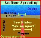
In divergence, magma from
the mantle wells up in the opening between plates. This upward flow
of molten material produces a continuous line of active volcanoes that
spill out basalt onto the ocean floor. This is usually represented by an
oceanic ridge. Divergence can also develop within a continent, resulting
in a rift valley.
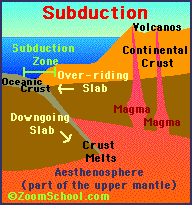
In convergence, plates moving
in opposite directions meet, and the result of the collision normally is
a vast crumpling of the edges as one plate subducts under the other. These
are destructive because they result in removal of part of the surface crust.
They are responsible for some of the most massive and spectacular of land
forms: mountain ranges, volcanoes, and deep oceanic trenches.
In lateral slipping, two
plates slip past one another laterally. The slippage edge is a great vertical
fracture called a strike-slip fault. These boundaries usually form huge
faults.
Alfred
Wegener and Pangaea

During the second and third
decades of the twentieth century, the notion of continental drift was revived
(back from around 1620 by Francis Bacon), most notably by the German meteorologist
Alfred Wegener. He put together the first comprehensive theory to describe
and partially explain the phenomenon in 1915. He proposed the thought of
continental drift, which states that parts of earth's crust slowly drift
atop a liquid core, and Pangaea (Greek for "whole land"). He postulated
that Pangaea existed about 250 million years ago and then broke up into
several large sections that have continued to move away from one another
to this day. Pangaea existed from the Permian through Jurassic period.
During the Jurassic period, Pangaea stared to break up, forming continents
Gondwanaland and Laurasia, separated by the Tethys Sea.
Wegener accumulated a lot
of evidence to support his hypothesis, most notably the remarkable number
of close similarities of geologic features on both sides of the Atlantic
Ocean. Also, the petrologic and paleontologic records on both sides of
the Atlantic show many distributions that would be continuous if the ocean
did not intervene. Fossils of Mesosaurs (one of the first marine reptiles,
even older than dinosaurs) were found in both South America and South Africa.
These finds, plus the study of sedimentation and the fossil plant Glossopteris
in these southern continents led Alexander du Toit, a South African scientist,
to bolster the idea of the past existence of a super continent in the southern
hemisphere, Eduard Suess's Gondwanaland. 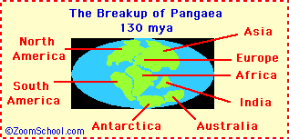
How the atmosphere was
affected by continental drift
The history of Earth
contains a lot of changes in its climate. Evidence from rocks and fossils,
like lush ferns and alligators found in what is now Siberia, or Dinosaur
skeletons from north of the Arctic Circle show that temperatures on the
Earth have generally fallen in the past 200 million years. Around 100 million
years ago, the mid-Cretaceous climate was around 2
to 6 degrees Celsius (3.6
to 11 degrees F) warmer at the equator, and 20 to 60 degrees Celsius (36
to 110 F) warmer at the poles. This is due to the fact that the atmosphere
levels were higher in the past. There are many theories that try to explain
the changes in climate. We will be focusing mainly on the theory of continental
drift.
Faster spreading rates of
the continents would lead to faster rates of subduction of carbonate sediments
and this, called weathering, in turn, would have led to increased rates
of CO2 production. There is evidence that indicates that the
sea floor was spreading faster at the time of Pangaea's breakup than it
has in any other time of geologic past. The main reason the atmospheric
level was so high was from weathering. Weathering changes the Earth's surface
by both chemical and
physical action. The unpolluted
pH of rainwater is generally between 5 and 6. Rocks exposed at Earth's
surface undergo chemical attack from this weak acid, one version of chemical
weathering. Through chemical weathering, rocks
break down by the action
of oxygen, carbon dioxide, and moisture, which absorbs organic acids from
decaying animal and vegetable matter. Carbon dioxide readily dissolves
in rainwater and sea water. Part of the rock is changed into soil and the
rest is dissolved. Chemical weathering is most important in damp regions
and physical weathering causes the most erosion in dry regions. The wind
constantly wears away the surface of soft rocks. Water freezing, then thawing,
also weather away at the rocks by cracking rocks near the surface. More
weathering means more carbon into the atmosphere,
which means a higher level
of heat. More CO2 may also have been released by mid-ocean ridges
themselves. Also,
since there was a higher
sea level at that time, it would have meant that there was less land area
available for weathering. This was caused by faster sea-floor spreading
and the lack of polar ice. Equatorial continents should have been warmer
and wetter than Earth as a whole (again assuming the planet's obliquity
was low) and should have had higher rates of silicate weathering. This
would have led to draw down of atmospheric CO2, thereby cooling
the entire planet. So, equatorial continents may actually cause global
cooling.
Starting about 80 million
years ago, Earth's climate began to cool. The initial decrease may have
just been caused by a decrease in mid-ocean ridge spreading rates, which
would lead to a reduction in atmospheric CO2. The cooling trend
accelerated around 30 million years ago during the Oligocene epoch in a
way that does not really correlate with the spreading rate data. So, paleoclimatologists
have searched for other explanations for the observed cooling. An interesting
theory is that the carbonate-silicate cycle was perturbed by plate tectonics,
but by a mechanism that differs from those
discussed previously.
This mechanism is mountain
formation. Around 40 million years ago, the Himalayans and Tibetan Plateau
were created. The Himalayas provided new erodable material on which silicate
weathering could proceed quickly, and the Tibetan plateau created seasonal
rainfall. These were the southeast Asian monsoons. The new mountains and
rainfall provided for more erosion and weathering, contributing to the
cooling of Earth. In addition, the smaller continents of Laurasia and Gondwanaland
would have reduced the amount of land available to weather silicate rocks
store
carbonate rocks, so the
CO2 sink would have been smaller. A more detailed explination
of this appears below.
There are other possible
influences on the climate during this time of the Mid-Cretaceous Period.
The equator-to-pole temperature contrast during the Mid-Cretaceous Period
was only 20 to 30 degrees C, as compared with 50 to 60
today. Part of this difference
can be explained by the absence of polar ice at that time. Remember that
ice cover has a strong, positive feedback loop. If we melted the ice caps,
it would cause a large decrease in the albedo of
the polar regions which
would cause them to warm significantly. Another influence on the climate
was the thermohaline circulation of the oceans. At this point in time,
they ran backwards: warm, but highly saline, deep water formed at low latitudes
and welled up near the poles, where it then warmed the climate through
evaporation. Unfortunately, nobody has yet
demonstrated that
this mechanism could work. Also, it has been thought that the tropical
Hadley circulation extended further poleward than it does today. Hadley
cells are very efficient at transporting heat. Bringing up the "Faint young
sun" paradox, that the sun gets brighter as it ages, it is also possible
that as solar luminosity gradually went up, atmospheric CO2
levels
gradually went down.
High levels of atmosphere
may also have been caused by other factors than continental drift. One
theory is that there have been variations in the amount of heat radiated
from the sun. Another is that huge quantities of dust, put into the atmosphere
during periods of intense volcanic activity, have decreased the amount
of solar radiation reaching the Earth. Another is
that increased amounts of
carbon dioxide, water vapor, and ozone--from volcanoes and from plants
as well--have absorbed more of the sun's heat and thus lowering average
temperatures. In a different aspect of warming and
cooling, the addition of
carbon dioxide to the atmosphere as a result of burning more and more fossil
fuels may cause global warming of atmosphere and oceans and extreme changes
in climate, a problem we are dealing with
today.
|
120 to 90 Million
Years Ago
|
100 Million Years
Ago
|
60 Million Years
Ago
|
--
Mid Cretaceous Period
-- Much warmer than
today, especially
at
the higher
latitudes
-- Continents were in
different places
so
there were
different
mountain chains
and
shallow seas
in the
places they
are today |
--
5 to 15 degrees
Celsius warmer
than today-
believed to
be
caused by the
different
continents'
arrangement |
--
A warm equatorial
sea way split
the
land horizontally
-- Warm, swirling
currents brought
to all the
oceans
-- A cold current
circled the
globe when Australia
split from
Antarctica
-- The warm
equatorial
sea ways
were blocked
by
land as the
continents
continued to
move,
-- Oceans now
separated and
connected to
the
polar latitudes
by
huge cold current
swirls |
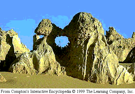
Mountain
Building
To understand mountain building,
you must first take alook at plate tectonics. Plate tectonics is
the theory that the Earth is made up of thin, rigid plates that move relative
to each other. The movement and the different type of movement causes
a variety of effects that affect the Earth in a number of ways. The
type of movement that mountain building is most concerned with is convergent
movement. There are three types of convergent boundaries: between
two oceanic plates, between an oceanic and continental plate, and between
two continental plates. The types of boundaries that we must understand
are boundaries between an oceanic and continental plate, and between two
continental plates. This will then shed some light as to how mountains
were essentially built.
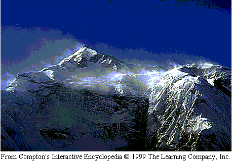
When a continental and oceanic
plate converge, volcanoes tend to form. Stress from the subduction
of one plate forces the other to fold, which forms volcanoes. The
Andes was formed in such a way. Volcanoes played an important role
in affecting the climate of Earth. The Pacific crustal plate began
to slide under the South American plate and formed the Andes. When
two continental plates converge, again, subduction occurs. The end
result is usuyally a doubling of the land mass involved at the boundary.
Uplift, folding and wrinkling occur from the pressure exerted by
the two plates an dmountains form. The Himalayas were formed this
way with the collision of India and Asia which is still occurring to this
day. This occurred during the end of the Mesozoic Era and on into
the present day.
When a volcano erupted, it
released large amounts of carbon dioxide and water into the atmosphere.
While the carbon dioxide was largely used by plants for photosynthesis,
sunlight broke down the water molecules into hydrogen and oxygen molecules
that added to the growing ozone layer. MOuntains play other important
roles regarding climate. Mfany block moisture dense clouds from passing,
forcing them to precipitate on one side of the mountain while leaving the
other side relatively dry.