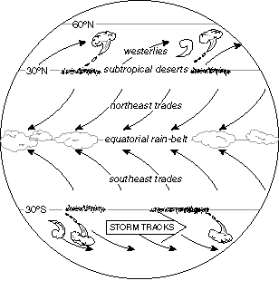
Fig. 1 Schematic depiction of the major climate belts on Earth.
If we look at the climate of Planet Earth without going into very much
detail, we
can see a number of very basic features that seem to depend only upon
latitude,
as sketched in Fig. 1: (a) an equatorial rain belt which shows up clearly
in the annual
mean rainfall (the blues and purples in Fig. 2)
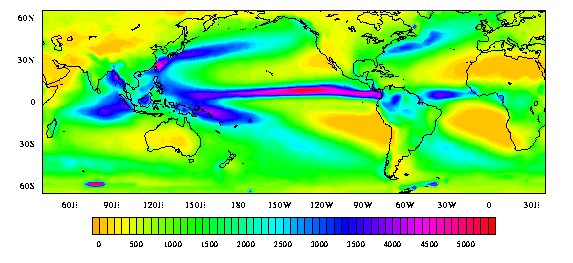
Fig. 2 Annual mean rainfall based on station data over land
and infrared satellite
imagery over the sea. For monthly mean maps and animations
see
http://tao.atmos.washington.edu/legates_msu/index.html)
(b) the tradewind belts (northeasterly trades in the Northern Hemisphere
and
southeasterly trades in the Southern Hemisphere), flanking the equatorial
rain
belt (Fig, 3),
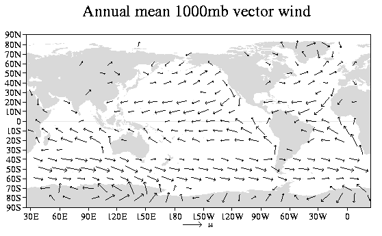
Fig. 3 Annual-mean surface winds over based on the NCEP/NCAR Reanalyses
(c) the subtropical deserts (indicated by the yellows and browns in
Fig. 2)
(d) the midlatitude westerly belts (Fig. 3) which are disturbed by
an unending
sequence of disturbances called extratropical cyclones. We viewed
an extratropical
cyclone over the North Pacific on the web in class. To see what's
out there now,
check out the visible and infrared satellite imagery on the departmental
web site at
http://www.atmos.washington.edu/data/weather.html#satellite.
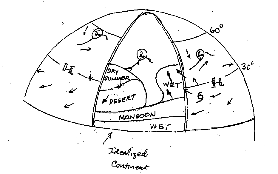
The above figure shows the climate zones on an idealized continent.
The equatorial
belt experiences ample rain year round. It's wetter and wider about
the equator on
the eastern side of the continent where the trade winds carry greater
amounts of
moisture from the ocean onto the land. Pole-ward of the equatorial
rain belt is the
monsoon belt in which the rains are largely restricted to the summer
season. The
climate in this belt is still tropical but the winters may be a few
degrees cooler
than the summers. The hottest month of the year is often in late spring
or early
summer, just before the monsoon rains set in.
The climate becomes drier as one proceeds pole-ward into the sub tropics
where we
encounter the sinking branch of the Hadley cell. The notable exception
to the
dryness is the eastern part of the continents, where the flow of warm,
moist air
around the western side of the oceanic sub tropical anticyclone brings
summer
rains, sometimes in the form of hurricanes and tropical cyclones. The
driest
regions tend to be toward the western sides of the continents: the
location of the
world's great deserts.
Proceeding pole-ward into the westerly belt, the dry summers persist
up to
latitudes of around 45 degrees, but extra tropical cyclones embedded
in the
westerlies bring winter rains that tend to be especially heavy over
and on the west
slopes of mountain ranges. Because of the pronounced summer dry season,
the western
sides of continents tend to receive most of their annual rainfall during
winter.
Pole-ward of 45 degrees these seasonal contrasts in rainfall are less
pronounced and
they are less easy to characterize in terms of an idealized continent.