Annual mean temperature decreases with latitude because at higher
latitudes solar
radiation strikes the earth at a more oblique angle. The temperature
contrast
between equator and pole is much stronger during winter than during
summer:
in the region of the polar night, there isn't any solar radiation at
all, whereas
during summer, the long hours of daylight in the polar regions compensate
for
the fact that the sun is lower in the sky. It follows that the
seasonal temperature
contrast is much larger in high latitudes than in low latitudes (see
Fig. 4.1 on p.
57-58 of the text). The major climate belts discussed in yesterday's
lecture
(i.e., the tropical rain areas; the tradewinds; the subtropical deserts;
and the
westerlies can also be characterized in terms of the latitude ranges
that they occupy.
The higher heat capacity of oceans damps seasonal temperature range,
as is clear
from the third panel of Fig. 4.1 (p. 58) in the text. Water has
much higher heat
capacity than soil and because it is a fluid capable of undergoing
convection, it
mixes heat downward through a much deep layer. Over land,
heat is transferred
downward from the surface (or upward from below) only by conduction,
which
is a much less efficient process than convection. That's why
temperatures in caves
just a 10 m below the surface stay nearly constant year round, while
temperature
100 m deep in the ocean vary with season almost as much as the sea
surface
temperature does.
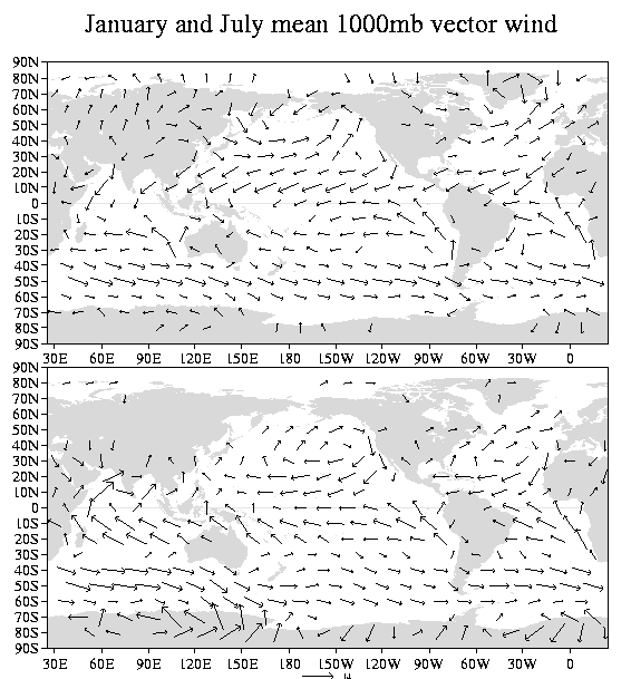
The west coasts of continents have milder summer climates than east
coasts because
the circulation around the oceanic subtropical anticyclones carries
cool air equatorward
along their eastern flanks (e.g., along the coasts of Washington, Oregon,
northern
California and Chile) and warm humid air northward along their western
flanks
(e.g., into China, Japan and the eastern United States). These
temperature contrasts
are reinforced by the wind driven ocean currents (Fig 5.3, p. 81) and
by the coastal
upwelling discussed in the next lecture. Prevailing onshore winds carry
moisture which
enhances rainfall. For example, the heavy winter rains in the
Pacific Northwest are a
reflection of the strong onshore flow of moist air. Whenever
the flow switches to
offshore, the rain stops. The onshore flow from the Gulf of Mexico
is the major
moisture source for the abundant year round rainfall over the central
and eastern
United States. Were it not for the flow off the Gulf, the Great Plains
would have
a semi-arid climate.
Fig. 1 January (top) and July (bottom) climatological-mean surface
winds
Higher altitudes experiences colder climates. There are glaciers
and year round
snow fields even in the equatorial belt. In general , higher
altitudes experience
more of their precipitation in the form of snow. Windward slopes
of mountain
ranges tend to have wetter climates, as evidenced by the widely contrasting
rainfall
regimes within the state of Washington. Mountains can act as
barriers, blocking
cold air masses, and the flow of moisture into landlocked regions.
The Cascades
often prevent bitterly cold Arctic air masses from reaching Puget Sound
with full
force and in summer they prevent eastern Washington from experiencing
the cool
'marine pushes' that bring the Puget Sound area relief from summer
heat. The
blocking effect of mountain ranges is responsible for responsible the
existence of
Kara-Kum, Taklimakan, and Patagonian deserts (Fig. 4.24).
For a detailed view of the topography over the United States, see
http://www.research.digital.com/SRC/personal/birrell/reliefMaps/
.
More detailed view by state are available at http://fermi.jhuapl.edu/states/states.html.
Vegetated terrain tends to be cooler during the daytime and vegetated
terrain experiences
more summer precipitation when about half the rain that falls comes
from water vapor
that was evaporated locally.
Animations showing how the distribution of rainfall over the globe
vary with
season can be found on the web at http://tao.atmos.washington.edu/legates_msu/index.html
(Scroll down to Analyses) Much of the following discussion is
based on the
examination of those animations that we performed in class.
Most land areas within 5-10 degrees of the equator receive copious year-round
due
to the more or less constant presence the ITCZ (loosely defined over
land).
Temperatures remain nearly constant year round at around 27 C.
This dependably
warm, moist environment supports the diverse ecosystems that exists
within the
tropical rain forests of the Amazon, equatorial Africa, and Indonesia.
Proceeding poleward to 15-20 degrees latitude, we encounter the monsoon
climates-- so named because they are characterized by well defined
wet and
dry seasons. ('monsoon' comes from the Arabic word for season.)
The rainy
season is confined to a few months centered during summer when the
equatorial
rain belt extends far enough poleward to encompass the region. The
hottest
weather of the year occurs just prior to the onset of the summer monsoon
rains.
Winters in the monsoon belt are a few degrees cooler than summer, but
they
still have a tropical feel to them. Regions with monsoon climates
include India,
central America, Subsaharan Africa and northern Australia.
Proceeding poleward to the belt centered near 30 degrees we encounter
the desert
climates which dominate all the western continental regions and extend
westward
across vast expanses of the oceans as well. The Sahara, Arabian,
Namib, Atacama,
Great Sandy (Australian) and Kalahari deserts all lie within this belt.
Notable
exceptions to the prevailing dryness of the subtropics are the humid
subtropical
climates of the eastern continents, (e.g., the southeastern United
States and China,
the east coast of Australia, northern Argentina, Uruguay and southern
Brazil.
Frequent incursions of warm, moist air on the west side of the subtropical
oceanic
anticyclones provide the moisture for summer rainfall to these regions
and winter
storms passing poleward of them bring winter rains.
The belt of temperate climates centered around 40 degrees latitude exhibits
less
contrast between the eastern and western sides of the continents.
The most notable
difference is the prevalence of winter rainfall in the west as contrasted
against year
round rainfall in the east. The dry summers in the west tends
to limit the extent of
forests to the higher altitudes, where temperatures aren't as hot.
Farther poleward, the climate zone extending from 50 to 60 degrees latitude
supports the largely coniferous boreal (northern) forests of Canada
and Russia,
which blend into tundra by the time one reaches the Arctic circle.
Vegetation zones
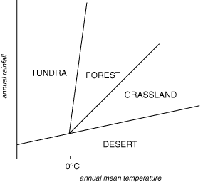
Fig. 2 Vegetation regime diagram.
Figure 2 shows how the various vegetation regimes (desert, tundra, grassland,
and
forests) relate to annual mean temperature and rainfall. Since
water is required
to sustain life, deserts prevail for very low rainfall, regardless
of how warm or
cold the temperature is. Tundra prevails for annual mean temperatures
below
freezing, because these conditions favor permafrost, which only supports
tundra.
By moving straight up in the diagram you can see that at any given
temperature
more rainfall is required to support forests than to support grasslands.
By moving
from left to right on the diagram you can see that for a given amount
of rainfall,
forests give way to grasslands as the annual mean temperature rises
and if it gets
hot enough, grassland eventually gives way to desert. These changes
reflect the
fact that the rate at which water evaporates at the earth's surface
increases with
temperature. Just as indoor plants need to be watered more frequently
if the house
is maintained at a warmer temperature, natural vegetation of a given
type requires
more rainfall in warmer climates than in cooler climates.