Oceans
97.+
Cryosphere
2.+ (90% of this is the Antarctic ice sheet)
Ground Water 0.6
Lakes and Rivers 0.02 (70% of this is in Lake
Baikal!)
Atmosphere
0.001
The Oceans consist of salt water. The salinity of sea water
is usually close to
35 grams of salt per kg of water (equivalent to 35 parts per thousand
or 3.5%).
Salt is released by weathering of rocks and carried into the oceans
by rivers.
This process would cause the salinity of the oceans to increase without
limit,
were it not balanced by the removal of salt by the mechanisms discussed
in the
text. In continental regions like the Great Basin of the western
United States,
where the rivers don't flow to the sea, the salts dissolved by weathering
end up
in salt lakes and/or salt marshes. Salt water is denser than
fresh water at the
same temperature. Hence objects like human bodies float at a
higher level in sea
water than in fresh water, and at a higher level still in extremely
saline waters
like those in the Great Salt Lake.
Two processes that make sea water more salty are evaporation and the
formation of
sea ice, both of which systematically remove fresh water from the ocean,
leaving
the nearby residual water saltier than it was to start with.
Precipitation, river
runoff, and melting of sea ice or icebergs tend to freshen the surrounding
sea
water as mixing occurs. In regions like the ITCZ, where precipitation
exceeds
evaporation, the surface waters of the ocean tend to be fresher (by
up to 1 g/kg)
than regions like the subtropical anticyclones, where evaporation greatly
exceeds
precipitation.
In fresh water the temperature determines the density. Cold water
is always denser
than warm water at the same level. Water cannot be at rest with density
increasing
with height, since this would constitute and unstable equilibrium:
the slightest
stirring would trigger vigorous convection.
In salt water the situation is more complicated because density depends
upon both
temperature and salinity. Warmer / fresher water tends to be
less dense than
colder / saltier water, but saltier water can be less dense and float
on top of
fresher water if it is warm enough (compared to the saltier water).
Such is the
case for the outflow of relatively warm, saline water from the Mediterranean
Sea.
Over most of the oceans, temperature is the dominant influence on density,
but in
the polar regions where water is close to the freezing point, salinity
also plays
an important role.
Photosynthesis by microscopic organisms known as phytoplankton is
the base of the
food chain that fuels the marine biosphere. Phytoplankton are
'grazed' upon by
microscopic animals known as zooplankton which, in turn, are the food
for the next
higher links on the food ladder, and so on.
Phytoplankton thrive only within the uppermost layer of the oceans where
sunlight
is available. Sunlight in the visible part of the spectrum (and especially
the
warm colors) is strongly absorbed by water. Hence, the sunlit
'euphotic zone' is
restricted to the uppermost few tens of meters. Some creatures
are able to live
at greater depths, but nearly all the primary production of 'biomass'
(i.e., plant
matter in the bottom rung of the food ladder) takes place within the
euphotic zone.
Phytoplankton also require nutrients (phosporus, iron and other chemical
species).
Plankton 'blooms' would use up all the available nutrients in the euphotic
zone
within a matter of days if there were no way of replenishing the supply.
Plankton
and other living creatures that spend most of their lifetimes in the
euphotic zone
produce fecal matter that sinks to deeper layers and they eventually
die and their
remains sink into the darkness below. Fecal matter and dead organisms
eventually
decompose, but the freed up chemical nutrients do not become available
to support
the next generation of biomass until the ocean circulation lifts them
back up into
the euphotic zone. Hence, marine life tends to be concentrated
in zones of
'upwelling' where nutrient rich water from below the euphotic zone
emerges back
into the sunlight.
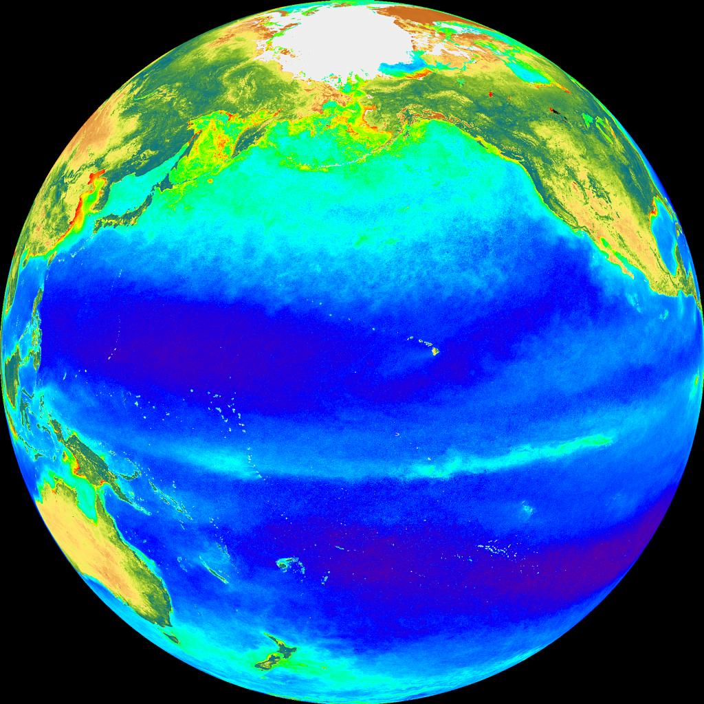
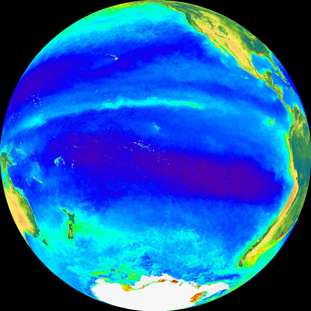
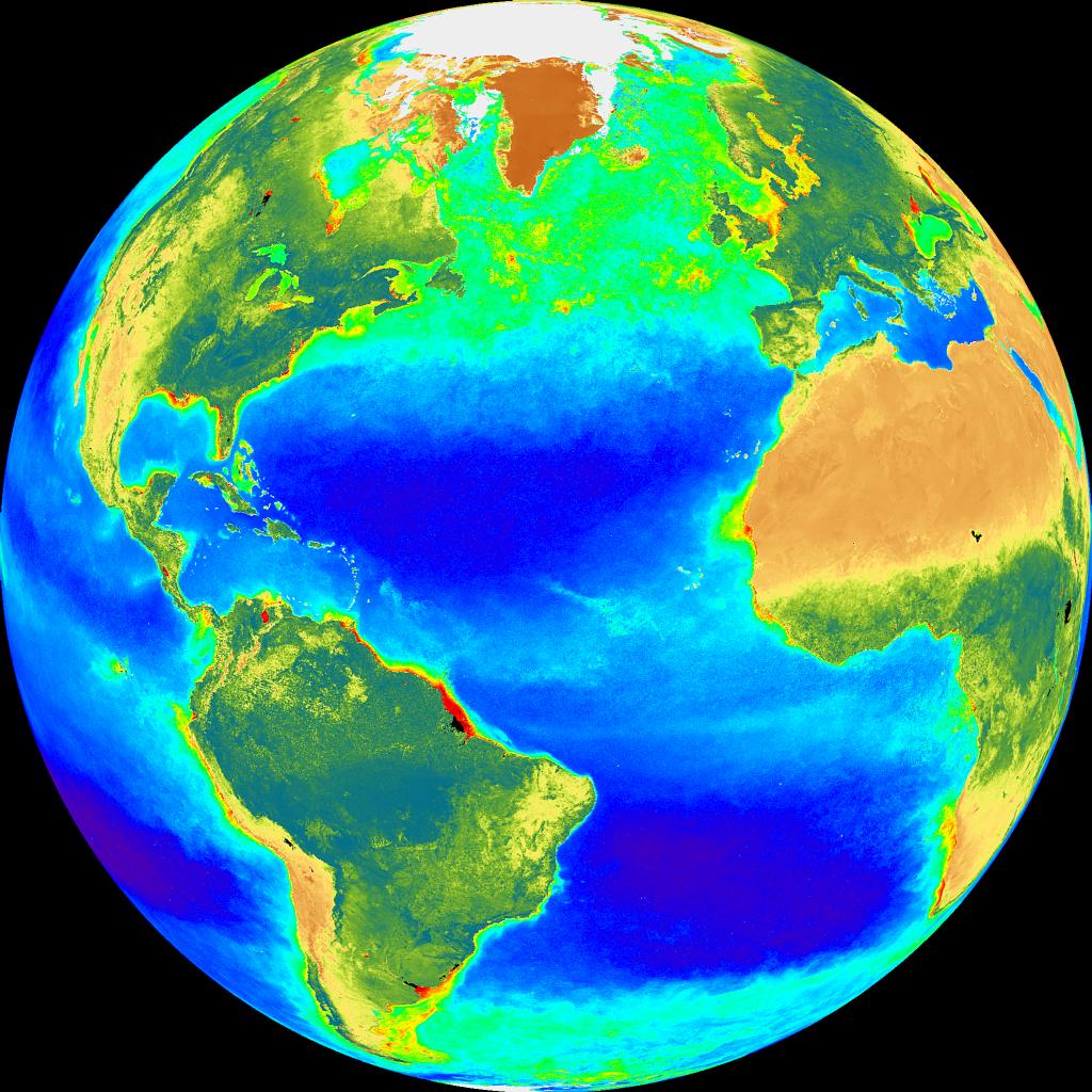
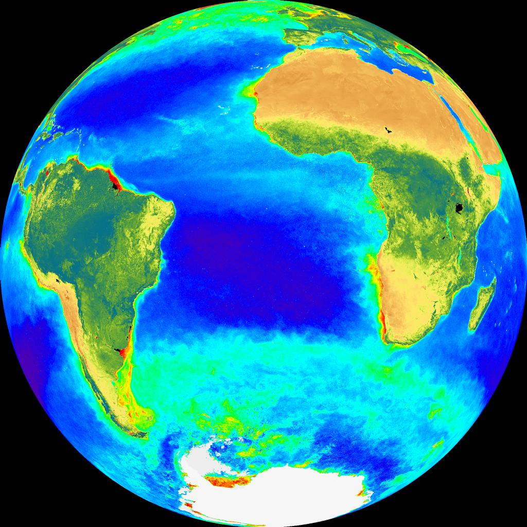
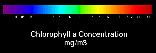
The chlorophyll in the living tissue of phytoplankton imparts a greenish
color to
sea water in regions of strong primary productivity. The distinction
on color is
visible to the naked eye, and it is highly visible when the surface
of the ocean
is scanned with an instrument that responds strongly to green light.
This is the
principle behind the design of NASA's
SeaWIFS instrument (click on the link).
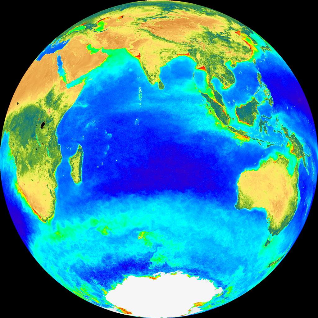
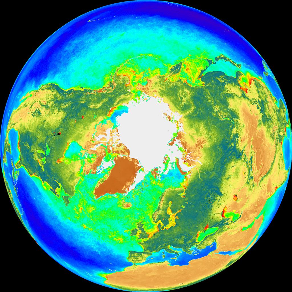
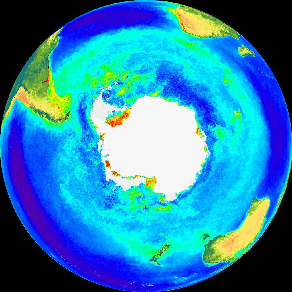
Upwelling tends to be concentrated within (a) regions where the wind
and ocean
currents circulate 'cyclonically' (in the same sense as the Earth's
rotation:
counterclockwise in the Northern Hemisphere and clockwise in the Southern
Hemisphere); (b) in certain coastal regions (c) and along the equator
wherever
winds blow from east to west. The reasons for this will be discussed
below in the
section on the wind driven ocean circulation. These upwelling
regions show up
clearly in the SeaWIFS imagery. They are the sites of the world's
most productive
fisheries.
The vertical structure of the ocean Over much of the world ocean, the
temperature
is fairly uniform within the uppermost few tens of meters. The
uniformity is due
to the mixing of the water by the surface waves. The stronger
the winds, the
deeper the effect of the surface waves penetrates and the deeper this
'mixed
later'. Below the mixed layer is a transition toward colder (denser)
water with
increasing depth. Temperature drops off rapidly with depth at
first, and then
more slowly, as shown in Fig. 5-8 of the text. This transition
zone is called the
'thermocline'. It is a layer which is very stable with respect
to vertical
displacements: e.g., a bubble of water that is lifted and released
experiences a
strong downward 'restoring force' because it is colder and denser than
the
surrounding water at its new level. The strong stability of the thermocline
tends
to impede the upward mixing of nutrients from below. Only when
the thermocline
gets close enough to the surface that it is strongly stirred by the
water waves
passing by overhead that the nutrients from below can be mixed into
the euphotic
zone.
The depth of the thermocline varies from place to place and also varies
with time,
ranging from as little as 10-20 meters to over 100 meters. Over
middle latitudes
it tends to be much deeper in wintern when wind waves are vigorous
than in the
quieter summer season. In a calm lake in hot summer weather the
thermocline can
be close enough to the surface so that swimmers are very much aware
of it. Below
the thermocline the ocean temperature is close to 4°C (39°F)
at all latitudes.
Analogous to temperature, salinity exhibits a 'halocline' with fresher
water above
and saltier water below, as illustrated in Fig. 5-8. The
halocline is an
importnat feature of the polar oceans, but over low latitudes it is
less important
than the thermocline.