The surface winds over the oceans tend to drag the surface waters
with them. In
the Pacific and Atlantic, where there are well defined northeasterly
and
southeasterly trades, the surface currents in the tropics are westward,
and over
the westerly wind belt from 40 to 60 degrees latitude, the prevailing
currents are
eastward. The continents block the eastward and westward currents,
thereby
causing the surface waters to circulate around anticyclonic (clockwise
in the
Northern Hemisphere; counterclockwise in the Southern Hemisphere) gyres,
centered
at subtropical latitudes as shown in Fig. 5-2 and 5-3 of the text.
At higher
latitudes there are smaller gyres that circulate in the opposite (cyclonic)
sense.
The surface currents over the Indian Ocean is not as distinct because
the winds
that drive it reverse with the seasons.
The 'dragging' of the surface waters by the winds implies a transfer
of momentum
from the atmosphere to the oceans: hence the term, 'wind driven'.
The actual
momentum transfer is accomplished through the generation and dissipation
of
surface waves, which move in the same direction as the wind.
The up and down
motions caused by surface waves extend to a depth of only a few tens
of meters,
but the wind driven currents extend deeper into the ocean due to processes
related
to the earth's rotation.
The Coriolis Force due to the earth's rotation acts to deflect the surface
currents toward the right in the Northern Hemisphere and toward the
left in the
Southern Hemisphere. [For an explanation of the Coriolis Force
see p. xx of the
text. You won't be required to learn it for this course.]
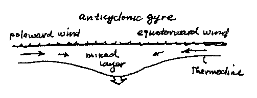
The surface waters
circulating around the subtropical gyres are deflected inward toward
the center of
the gyres, as pictured in the left panel of the figure above.
The accumulation of
surface waters in the interior of the gyre thickens the mixed layer
and depresses
the thermocline (as shown). It also causes sea level to rise
(as pictured in the
figures in the text) but this effect is very small compared to the
depression of
the thermocline. The depression of the thermocline keeps the
nutrients lower in
the water column than they are elsewhere in the world ocean.
Hence, the marine
biosphere is relatively inactive in the subtropical gyres: the waters
are
relatively clear (chlorophyll free) and show up dark blue in the SeaWIFS
imagery.
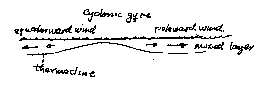
For the same reason, the surface waters circulating in the cyclonic
gyres on the
poleward side of the westerly wind belts is deflected outward, pulling
the
thermocline (and the nutrients) upward in the center of the gyre, which
tends to
enhance the production of chlorophyll (and fish) in these regions.
The tight
cyclonic circulations in hurricanes are sometimes strong enough to
bring the
thermocline right up to the surface within a matter of a day or two,
leaving
behind a patch of conspicuously cold water.
Very strong coastal upwelling is observed in regions where the surface
winds
circulating around the subtropical anticyclones blow parallel to the
coastlines.
One of these regions is the coast of Oregon and Northern California
during
summertime. The northerly (north to south) wind around the eastern
side of the
subtropical (Pacific) gyre drives a strong north to south coastal current
which is
deflected toward the right-- away from the coastline. As the
surface water drift
offshore, they are replaced by cold, nutrient rich subsurface waters.
In a
typical summer there may be intervals of a week or two when the northerly
winds
weaken and the upwelling stops. Within a few days the surface
nutrients are used
up, the biosphere goes dormant and the quality fishing abruptly declines.
At such
times, those whose livelihood depends on fishing watch the weather
forecasts for a
sign of the return of the northerlies. Other area where coastal
upwelling occurs
include the coasts of northern Chile and Peru and West Africa.
Equatorial upwelling occurs wherever the winds blow from the east.
Surface waters
just to the north of the equator are deflected toward the north and
surface waters
just to the south of the equator are deflected toward the south.
As the surface
waters drift away from the equator (in both directions) the equatorial
thermocline
is bulges up, close enough to the surface so that mixing from the surface
waves
can stir nutrients upward into the euphotic zone where phytoplankton
can feed on
it. Hence the equatorial belt show sup bright green in the SeaWIFS
images. The
zone is narrow because the phytoplankton growing in the upwelled water
go through
their life cycle in just a day or two-- not long enough for the upwelled
water to
diverge more than a few tens of km from the equator.