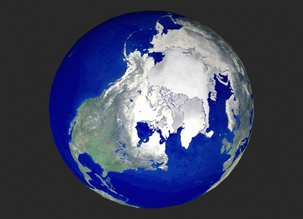
In the text the cryosphere is treated as a part of the hydrosphere.
It consists
of three major components:
sea ice (also called 'pack ice') in the polar oceans:
important because it
covers a large area and is highly variable, so it exerts a strong influence
on
the earth's albedo
continental ice sheets: important because it accounts
for most of the mass of
the cryosphere
alpine glaciers: important because they are sensitive
indicators of climate
change over a wide range of latitudes, including even the tropics.
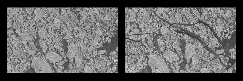
Scientists at NASA's Jet Propulsion Laboratory (JPL) have used high
resolution radar to see, for the first time ever, the
development of the Arctic sea ice cover. The images show a comparison
of ice growth during the Arctic winter. The two images are
separated by nine days. Both images represent an area located in
the Beaufort Sea, north of the Alaskan coast. This radar view
covers an area of 96 by 128 kilometers (60 by 80 miles). The brighter
features are older thicker ice and the darker areas show
young, recently formed ice. The earlier image is shown on
the left. Within the nine-day span, large and extensive cracks in
the
ice cover have formed due to ice movement. These cracks expose
the open ocean to the cold, frigid atmosphere where sea ice grows
rapidly and thickens. Formation of sea ice in the Arctic Ocean
affects the heat balance in the global atmosphere and ocean.
During wintertime, open leads and patches of open water that form when
the ice
is blown away from the coastline by an offshore wind freeze over very
quickly,
forming what is referred to as 'first year ice'. This new ice
thickens rapidly
at first, and then more slowly as it grows thick enough to insulate
the water
below it from the cold air above. It also thickens whenever ice
floes collide
and one 'rafts' above the other. Sometimes these collisions create
'pressure
ridges' (lines across the floes where the ice bulges upward into the
atmosphere
by a meter or two and downward into the water below by a comparable
amount).
Ice that has survived through at least one summer is referred to as
'multi-year
ice'. Ice formed in the Arctic Basin can survive for five years
or longer
before it is swept out through the Fram Strait. The typical thickness
of
multi-year ice on the order of a few meters but the ice can be much
thicker in
pressure ridges. Ice thickness was routinely monitored by U.S.
and Soviet
/Russian nuclear submarines while on missions in the Arctic.
Much of these data
have become declassified and made available for scientific use during
the past
few years.
Snow accumulates on top of sea ice during the colder months of the year
and
forms melt ponds on the ice surface during summer, when air temperatures
are
close to (but just above) freezing at the ice surface, but warmer aloft.
Low
stratus clouds formed by the cooling of the air near the surface are
trapped
within this low lying temperature inversion, making for a gloomy summer
climate
despite the midnight sun. Researchers much prefer being in the
Arctic during
winter night when skies are often clear.
http://antwrp.gsfc.nasa.gov/apod/ap991116.html
CAPTION: It's not easy to make a map of Antarctica. Earth's southern
most
continent is so cold and inhospitable that much of it remains unexplored.
From
space, though, it is possible to map this entire region by radar:
by
systematically noting how long it takes for radio waves to reflect
off the
terrain. The Canadian satellite RADARSAT has been orbiting the Earth
for the
past five years making radar maps, and has recently released the
most detailed
map of Antarctica ever created. Above is a computer-generated map
of Antarctica
at relatively low resolution. From the RADARSAT map, scientists
have been able
to better study this mysterious continent, including information
about how
ancient ice-shelves are crumbling.
The mass of the continental ice sheets was much larger during the ice
ages than
it is today, and global sea level was correspondingly lower, exposing
large
areas of the shallow seas. The continental ice sheets were so
heavy that they
depressed the earth's crust beneath them into the underlying mantle.
Parts of
Scandinavia are still rebounding following the melting of the ice sheet
that
covered the region 10,000 years ago.
The continental ice sheets are formed from the accumulation of snow
that forms a
succession of annual layers that gradually get compressed and turned
into ice as
more layers pile on top of them. As the snow is compressed, the
air within it
is trapped and preserved in small bubbles and retains the chemical
properties
that it had when it was deposited. As a newly formed ice sheet
grows to
maturity, its surface forms a dome centered over the interior of the
continent.
The domed shape is a result of the action of gravity that causes the
ice to flow
downhill toward the edges of the ice sheet and finally fall (or calve)
off the
edge. Ice under high pressure from the weight of the overlying
ice behaves as a
plastic medium, so ice from the interior flows outward toward the edge
of
continent to replace the ice lost to calving, while more snow and ice
piles on
top. When the ice sheet reaches equilibrium, the outflow of ice
that is lost in
calving along the edge of the ice sheet exactly balances the accumulation
of
snow and ice in the interior. It's a messy experiment, but one
can create a
domed surface that resembles the shape of an ice sheet by pouring a
thin stream
of a viscous liquid like honey uniformly across the top of an inverted
drinking
glass until a balance is reached between the honey being poured on
top and the
amount dripping over the edge of the glass.
The Vostok and Greenland ice cores are near the interior of their respective
continents where the outflow is very small and the accumulating annual
layers of
snow / ice are relatively undisturbed so that they remain intact over
tens and
hundreds of thousands of years. The Antarctic ice sheet is much
thicker, so the
Vostok core traces the history of the ice much farther back in time.
Mountain glaciers account for a small fraction of the mass of the cryosphere
and
of the contribution of the cryosphere to the earth's albedo.
They are marked by
a similar balance between accumulating snow and ice in a dome in the
upper part
of the glacier and 'calving' of pieces of ice or summertime melting
at the
snout, which is usually located at much lower elevation, where air
temperatures
are much warmer. Many mountain glaciers exhibit a recurrent pattern
of sudden
surges that last for a few years, alternating with much longer periods
of slow
retreat. Such glaciers are retreating most of the time, but they
have to be
observed over an interval long enough to include one or more of the
surges in
order to get a clear indication of what's really happening to them.
The Carbon
glacier on the west side of Mt. Rainier surged back in the 1960's but
has
retreated considerably since that time.
The theory of plate tectonics and continental drift was proposed
by Alfred Wegener
early in the 20th century but didn't become widely accepted until the
1960's. It
is supported by a variety of evidence as summarized in the text and
in the
presentation of Group X. It has important implications, not only for
the movement
of the continents on time scales of tens to hundreds of millions of
years, but
also for our understanding of chemical transformations that affect
the composition
of the atmosphere.
The theory holds that the earth's crust is broken up into plates that
float upon
the much thicker layer of porous but very viscous material that makes
up the
earth's mantle. Owing to slow convection within the mantle, the
plates move at
speeds ranging up to a few centimeters per year (or meters per century;
or tens of
km per million years). Plates that lie above regions of upwelling
in the mantle
are moving apart and plates that lie above regions of downwelling in
the mantle
are being pushed together (Fig. 6-27).
Earthquakes are observed to be to be concentrated along plate boundaries
(Fig. 6-12). Oceanic plates are thinner, but slightly denser
than continental
plates, so that when the two collide, the oceanic plate is pushed (or
'subducted')
underneath the continental plate and disappears as it is incorporated
into the
mantle (Fig. 6-15a, 6-21). Rocks in the subducted oceanic
crust are subjected to
increasingly higher temperatures and pressures as descend, causing
physical and
chemical transformations (referred to by geologists as 'metamorphosis':
change of
form) of certain rocks like carbonates (limestone). Subducted
ocean sediments
also carry with them hydrated rocks (i.e., minerals with water molecules
incorporated them). As the temperature increases, the water molecules
are
released as steam within the mantle.
One example of a region of subduction is the boundary of the Pacific
and Juan de
Fuca plates off the Washington coast, the site of mega-earthquakes
every few
hundred years. Subduction zones correspond to trenches on the
ocean floor.
Volatile substances subducted into the mantle are expelled in volcanoes
which are
usually located nearby.
Collisions between plate boundaries are often associated with volcanic
activity
(as in the Cascade range) and with the uplift of mountain ranges (Fig.
6-15). The
most dramatic of the earth's mountain ranges, the Himalayas, has been
created by
folding of the earth's crust following the collision of the Indian
and Asian
plates, which is still going on today. The Rockies, Cascades
and Sierra ranges
have been created in a similar manner, by the collision of the Pacific
and North
American plates.
Oceanic plates are continually being recycled. The Pacific plate
is being
subducted along much of its boundaries. Meanwhile, along the
mid-Atlantic ridge,
new oceanic crust is being formed as minerals upwelling in the mantle
rise to the
surface and cool (Fig. 6-13a). As this newly formed crust diverges
away from the
mid-Atlantic ridge, the Atlantic plate widens, taking up the space
lost by the
Pacific plate as portions of it are subducted. As the Atlantic
widens and the
Pacific shrinks, the continents may be viewed as drifting away from
the Atlantic
on trajectories that will eventually (in another 100-200 million years)
cause them
to converge over what is now the mid-Pacific. A similar congregation
of the
continental plates occurred about 200 million years ago when the continental
plates were clustered around what is now Africa. The giant land
mass that is
believed to have existed at that time is called Pangea (all earth).
The newly formed crust in the mid-Atlantic has a different chemical
composition
from the oceanic crust in the Pacific that is being subducted.
In place of
limestone (CaCO3) is metamorphosed calcium silicate (CaSiO2)
rocks in which the
limestone is combined with quartz (silicon dioxide, SiO2)
and carbon dioxide is
released (CaCO3 + SiO2 -> CaSiO3 +
CO2) , and hydrated minerals are absent. The
gaseous by products of the reactions that take place within the earth's
mantle
(CO2, H2) and H2) are released in
volcanoes. While these chemical transformations
are taking place in minerals processed within the mantle, the reverse
reactions
are taking place due to weathering in the continental plates and deposition
of
sediments in the oceans. Weathering exposes calcium silicate
rocks and decomposes
them into calcium ions that flow down the rivers into the oceans, and
residual
quartz (silicon dioxide, SiO2) rocks. Limestone is
formed in the shallow seas by
the deposition of these same calcium ions after they are incorporated
into
skeletons and shells.
On times scales of tens of millions of years carbon dioxide levels in
the
atmosphere are determined by the comparative rates of continental drift
(which
determines the rate of subduction, metamorphosis of limestone, and
release of
carbon dioxide in volcanoes) and weathering (which determines the availability
of
calcium ions for forming limestone. If continental drift predominates
over
weathering, atmospheric carbon dioxide levels should rise, and vice
versa. Over
the past 50 million years it is believed that weathering has predominated
(due to
the uplift of the Himalayas and the slowing down of continental drift):
hence, the
decrease in atmospheric carbon dioxide levels and the cooling of the
atmosphere,
which set the stage for the current glacial period.