Climate and Climate Change
Global Pattern of Temperature and Rainfall

Fig. 1
Schematic depiction of the major climate belts on Earth.
If we look at the climate of Planet Earth without going into very much detail, we can see a number of very basic features that seem to depend only upon latitude, as sketched in Fig. 1:
- an equatorial rain belt, the Intertropical Convergence Zone (ITCZ), which shows up clearly in the annual mean rainfall (the blues and purples in Fig. 2), as well as on satellite images of clouds (see the equatorial band of clouds in Fig 4). Note that the ITCZ is located, not exactly on the equator, but near 7 degrees N. It drifts northward to ~10 N during the norther summer and southward toward the equator during winter but it remains in the northern Hemisphere year round. Annual rainfall along the ITCZ is in excess of 100 inches per year at many locations.
- In Fig. 1 we can see the tradewind belts (northeasterly trades in the Northern Hemisphere and southeasterly trades in the Southern Hemisphere), flanking the equatorial rain belt (Fig. 3). In the idealized Fig. 1 the northeast and southeast trades converge right on the equator but in the real atmosphere they converge along the ITCZ. Where they converge the air is lifted and it is this continual lifting that produces the heavy and persistent rainfall along the ITCZ. Note that the southeast trades extend across the equator into the northern hemisphere.
- In Fig. 1 we can see the subtropical deserts (indicated by the yellows and browns in Fig. 2). We are accustomed to thinking of deserts as being on dry land but note how all the major subtropical desert regions extend westward from the western parts of the continents across large expanses of ocean. For example, the desert that affects the climate over the southwestern United States extends westward as far as the Hawaiian Islands. The desert regions are located in the sinking branch of the Hadley cell at a latitude intermediate between that of the trade winds and the westerlies. They're poleward of the monsoons and equatorward of the migrating weather systems that produce most of the rainfall at higher latitudes.
- the midlatitude westerly belts (Fig. 3) which are disturbed by an unending sequence of disturbances called extratropical cyclones. We viewed an extratropical cyclone over the North Pacific on the web in class (Fig 5). To see what's out there now, check out the visible and infrared satellite imagery on the departmental web site at: http://www.atmos.washington.edu/data/weather.html#satellite. If you have access to a high speed link, try the animated film loop at http://www.atmos.washington.edu/~ovens/loops/wxloop.cgi?ir_moll+/48h/3h

Fig. 2 Annual mean rainfall based on station data over land and infrared satellite
imagery over the sea. For monthly mean maps and animations see
http://tao.atmos.washington.edu/legates_msu/index.html

Fig. 3 Annual-mean
surface winds over based on the NCEP/NCAR Reanalyses

Fig. 4 The Earth
viewed from space with the GOES-11 satellite (May 2000). Visible image
over the Pacific Ocean. Beneath the clouds, you can see the outline of
the North and South American continents (click on the image to get a larger
view)
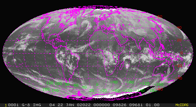
Fig. 5 is an image from todays global composite satellite loop. You can clearly see the ITCZ, the southern hemisphere summer monsoons, the cloud free desert belts and both the Northern and Southern Hemisphere storm tracks.
Seasonal Variations
The inter-tropical convergence zone is
largely restricted to the Atlantic and Pacific Oceans. Over the tropical
continents the rainfall is dominated by the monsoons. The word 'monsoon'
is derived from Arabic 'mausim' a season, meaning in this case, a seasonal
wind. It was originally used to describe the winds over the northwest part
of the Indian Ocean, which blow from the
northeast, off the Asian continent, during the winter months and from the
southwest, off the ocean during the summer rainy season, which lasts from
June until early autumn. This windshift shows up clearly in Fig.
6.
vacations in that part of the country).
In contrast to the ITCZ, which stays quite
close to 7°N year round, the monsoons shift back and forth between
Northern and Southern Hemispheres, following the sun, so to speak.
Many equatorial stations experience equinoctial (March and September) rainy
seasons when the monsoons pass overhead, whereas stations at, say, 10°N
or 10°S experienced well marked summer rainy seasons and winter dry
seasons. Monthly rainfall maps clearly reveal the 'annual march of
the monsoons, e.g., see http://tao.atmos.washington.edu/legates_msu/index.html
and scroll down until you get to the maps. For nice animations, see
http://tao.atmos.washington.edu/legates_msu/movie.mpeg
and http://tao.atmos.washington.edu/legates_msu/movie1.mpeg.
The Subtropical Anticyclones
As noted above, the deserts are located
in the transition zone between the trade winds and the westerlies.
During summer the winds in these transition zones develop a strong 'anticyclonic'
spin. Meteorologists and oceanographers use the term 'cyclonic' to denote
'in the same sense as the earth's rotation' and 'anticyclonic' to denote
'in the opposite sense as the earth's rotation'. In the Northern
Hemisphere, the sense of the earth's rotation (looking down from above)
is counterclockwise-- we know that because the sun rises in the east and
sets in the west. Hence, in the Northern Hemisphere, the word 'cyclonic'
is synonymous with counterclockwise and 'anticyclonic' with 'counterclockwise.
With a bit of mental gymnastics, you can easily verify that in the Southern
Hemisphere the terms have the opposite meaning. The words cyclone
and anticyclone are from the same root. They denote cyclonic circulation
and anticyclonic circulation, respectively. Hence, anticyclone' denotes
clockwise circulation in the Northern
Hemisphere and counterclockwise circulation in the Southern Hemisphere.
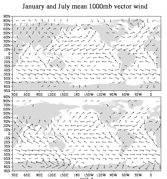
Note the subtropical anticyclones over the Atlantic, Pacific and Southern Indian Oceans in Fig. 5. They are much more prominent in the summer seasons in their respective hemispheres. Hence, the Northern Hemisphere subtropical anticyclones are easier to identify in the lower panel of the figure and vice versa. Note how it always works out that the winds during summer are equatorward on the west coasts of the continents..(e.g., on the coasts California, Chile, Portugal, Namibia) and poleward on the east coasts of the continents (e.g., eastern United States and China, Japan, Argentina and Angola).
The subtropical anticyclones are also commonly
referred to as 'subtropical highs' because they are regions of high barometric
pressure. Sailors prefer to avoid
them because they're regions of calm winds.
Note that cyclonic circulations are also
apparent in Fig. 5 [ROBB, the same one] The place
to look for them is in high latitudes of the winter hemisphere: i.e., over
the Aleutians and south of Greenland in the top panel of the figure.
These features are referred to as the Aleutian and Icelandic lows.
They're semipermanent features of the wintertime circulation. They're
marked by stormy weather and intermittent periods of high winds.
Last
Updated:
01/22/02