Atmospheric Sciences 101: Weather
Autumn 2012
Current Weather and Climate Information Links:
Current weather information and forecasts
-
Western
Washington Weather Forecasts from the National Weather
Service
-
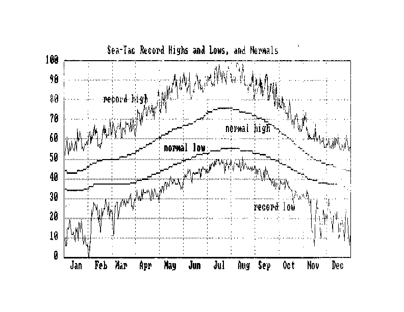
Sea-Tac
meteogram
-
UW ATG rooftop
west-facing webcam (follow links to view webcam cloud loops)
- Forks sounding
(Unisys)
- Lower-atmosphere profiles of wind
and virtual temperature over
NE Seattle remotely sensed using a wind profiler and RASS at NOAA Sand Point.
- Soundings
from around the U.S. (U. Wyo., nicer format than above)
- Northwest/N Pacific 24 hr satellite loops:
IR,
water
vapor.
- Today's
WA visible-wavelength satellite loop.
- Camano Is. radar loop and Pacific NW composite radar loop
- NAM forecast model 0-72 hr loops (eastern Pacific and western N America):
sea-level pressure(SLP) and precipitation
- UW Pacific Northwest WRF forecast model loops, 4 km domain:
Washington 4 km SLP, winds, 925 mb temp, precipitation,
surface
temperature.
- National 3 hr radar loop
- N Pacific/US 12 hr geostationary satellite loops of IR,
Vis,
water vapor.
- National
surface analysis (sea-level pressure/winds/weather).
- Loops using NCEP Global Forecast System model
analyses and forecasts, 7.5 days ago to 7 days ahead:
NE Pacific/N America-centered 500 mb height and
500
mb/SLP. Click on d(model)/dt button at the top of each loop to
compare forecasts for a given time that were initialized at different times.
-
Department of Atmospheric Sciences
Weather and Climate Data Page (local weather info, forecasts, highway reports; MM5 regional
forecast model output, and many links)
-
Many more UW weather loops
-
Unisys Weather (national and regional
plots of current weather conditions, weather forecast model output, hurricanes,
sea-surface temps (under Archive link)--all you need to be a weather weenie!),
-
National Weather Service: Seattle,
WA (complete local weather reports, climate info, marine forecasts,
river conditions)
-
Current mountain weather
from automated sites (including most ski areas) around the Cascades and Olympics
-
Northwest Avalanche Center
-
WSDOT highway weather
info, traffic-cams, etc.
-
Intellicast (weather forecasts
and ski conditions)
-
NOAA Geostationary Satellite Server
- real time satellite imagery for most parts of the world and all regions
of the US.
-
Meteosat Full Disk
IR (centered on Europe/Africa)
-
GMS Full Disk IR
(centered on eastern Asia and Pacific)
-
Data going into this morning's forecast (from ECMWF, Reading, England)
-
NCEP Global Forecast System Ensemble Forecast
Spaghetti Plots (5550 and 5760 m contours of 500 mb height for all 1-15 day
forecasts in ensemble, looped over current 1-15 day forecasts to show how
predictability of weather degrades with time).
Climate, climate change, ozone hole
Other interesting atmospheric phenomena
Current interesting weather links
Movie Demos:
-
Animated molecular gas dynamics tutorial
-
Balls
on a Rotating Plane: This illustration is in some ways analogous to
the Coriolis Force. However, the curvature of the earth's surface and the
effects of gravity are not taken into account. Requires Quicktime.
-
A
Parcel (Initially at Rest) Reaching Geostrophic Balance: This demonstration
provides force diagrams at succeeding parcel positions. The red arrows
indicate the pressure gradient force, the green arrows indicate the Coriolis
Force (which always points 90 degrees to the right of a parcel's motion
in the Northern Hemisphere), and the dashed blue curve indicates parcel
position with time. Requires Quicktime.
Back to 101 home page.