C-130 Instruments
The NSF C-130 aircraft
instrument payload for VOCALS-REx is given in Table 1. A total of 90 hours
research time is requested for the C-130 to make approximately 10 flights of 9 hours
duration. Preliminary costs estimates have been provided by NCAR Earth
Observing Laboratory (EOL). The C-130 will be based either in
The C-130 will be equipped
with the full range of in-situ
meteorological, turbulence, and microphysical probes,
and a dropsonde system will be used to give the
large-scale meteorological context. A scanning backscatter lidar (SABL) will be
used in vertically-pointing mode (both up and down) to detect cloud boundaries.
The 95 GHz (W-band) Doppler polarization Wyoming Cloud Radar (WCR) will be used
above cloud as depicted in Fig. 3 to detect the structural and kinematic structure of drizzle within and below
stratocumulus clouds using dual antennas to carry out dual doppler analysis and obtain horizontal wind
components along the flight direction. This configuration was employed
successfully in the Dynamics and Chemistry of Marine Stratocumulus (DYCOMS-II)
campaign in 2001.

Figure 3: Proposed WCR
configuration on the C-130 during VOCALS-REx. Three derived fields are shown
(reflectivity, vertical Doppler velocity, and horizontal winds).
A comprehensive chemistry
and aerosol sampling suite will be carried on the C-130. This includes
atmospheric pressure ionization mass spectrometry (APIMS) measurements of
sulfur dioxide and dimethylsulfide (DMS),
condensation nuclei (CN) and cloud condensation nuclei (CCN) counters, tandem
differential mobility analyzer (DMA) aerosol size distributions and humidity
growth factors for particles from 5-500 nm in diameter, scattering nephelometer measurements, and cascade impactor
size-resolved aerosol chemical speciation. The suite is a slightly reduced
version of that employed during ACE-ASIA. See Table 2 in Section I of the SPO
(included at the end of this document) for a complete list of the proposed
instrumentation in the C-130 chemistry and aerosol suite.
Passive remote sensing
measurements will be made with high spatial resolution using NCAR’s Multichannel Radiometer
(MCR) and Advanced Imaging Microwave Radiometer (AIMR). These instruments will
provide the measurements of cloud liquid water path, optical depth, and the
effective radius of cloud droplets necessary to quantify how cloud
microphysical properties affect the optical and structural properties of low
clouds over the SEP.
Table 1: NSF C-130 aircraft instrument requirements
|
Instrument |
Observations |
Funding
source |
Contact |
|
|
Cloud and precipitation structure,
dynamics of precipitating systems |
NSF Deployment pool |
|
|
FSSP, 2D-C, 260X, PCASP Gust probe, temperature and humidity
sensors |
Cloud microphysics, thermodynamics,
turbulence, dynamics |
NSF Deployment pool |
NCAR RAL (standard instrument suite) |
|
Dropsondes (15 per flight) |
Lower tropospheric
and boundary layer structure |
NSF Deployment pool |
NCAR RAL |
|
Scanning Aerosol Backscatter Lidar (SABL) |
Cloud top and base height |
NSF-Clim |
NCAR RAL |
|
APIMS (Atmospheric Pressure Ionization Mass
Spectrometry) |
SO2 and DMS high frequency gas phase
measurements |
NSF-Chem (SOLAS) |
Bandy, |
|
CCN Spectrometer |
Cloud condensation nuclei |
NSF-Clim |
Snider ( |
|
Aerosol physicochemical measurement suite
|
Aerosol number concentration, size
distribution, chemical composition, optical properties |
NSF-Chem (SOLAS) |
Howell and Huebert
( |
|
Multi Channel Radiometer (MCR) |
Passive remote sensing of cloud effective
radius and optical depth |
NSF Deployment pool |
Tschudi (NCAR EOL) |
|
Airborne Imaging Microwave Radiometer
(AIMR) |
Passive remote sensing of cloud liquid
water path |
NSF Deployment pool |
Haggerty (NCAR EOL) |
NOAA R/V Ronald H
Brown instruments
The R/V Ronald H Brown
(RHB) instrument payload is given in Table 2. The RHB has already been
requested as part of NOAA CPPA proposal by Chris Fairall at NOAA ESRL. A total of
45 days have been requested, of which approximately 35 during the entire month
of October will constitute the intensive observational phase of VOCALS-REx. The
C-130 and RHB deployments will be fully overlapped in time to maximize the
synergy between the two platforms.
The RHB will be equipped
with a set of cloud remote sensing instrumentation which will sample almost
continuously throughout the cruise. A vertically-pointing
stabilized 35 GHz sensitive millimeter radar will provide high vertical
resolution (≈20 m) reflectivity profiles along with doppler spectral information for the determination of the
size distribution of falling drizzle drops and from this the precipitation
rate. A three-channel (20.6, 31.6 and 90 GHz) microwave radiometer will be used
to determine the cloud liquid water path, and a
A
scanning C-band (5 cm
wavelength) precipitation radar with a sensitivity of -12 dBZ will be used to
determine horizontal and vertical structure, kinematics and evolution of the
precipitation field within a 30 km radius of the ship (Fig 4). The C-band beamwidth is better than 500 m within 30 km of
the ship, and the antenna is electronically stabilized to remove ship motion.
There is negligible attenuation within drizzling stratocumulus. These
measurements have also been invaluable in providing the first accurate
determination of the statistical properties of precipitation in marine
stratocumulus. A scanning strategy similar to that carried out in EPIC 2001
will be used in VOCALS-REx.
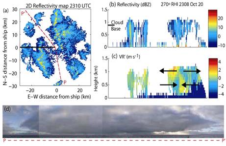
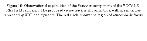
Figure 4: Example of
C-band capability for observation of drizzle cells in stratocumulus cloud. (a)
horizontal reflectivity map showing cellularity; (b,c) RHI scans showing vertical cross sections (along solid
line in marked in (a)) detailing the structure and kinematics of the inflow and
outflow regions of the mesoscale cell pictured in the photograph composite
between P and P’.
The RHB will also carry an
extensive suite of in situ aerosol instruments, with which to record a
time-series of aerosol physical and chemical properties. These will include
integrated measurements of bulk and size-distributed aerosol chemistry as well
as physical size distributions and light scattering and absorption. We hope to
also have a single-particle aerosol mass spectrometer aboard, with which to
look at issues such as the presence of organic carbon and halogens in small
sulfate aerosols. These will all be focused on aerosol indirect forcing of
climate: what controls the nucleation of new particles and their growth into
the CCN size range? Since most of the aerosol growth is expected to be via
sulfate condensation, we will also measure ozone and the gas-phase precursors
DMS and SO2. The latter two will be measured by APIMS-ILS, so that
we can constrain the MBL sulfur budget by measuring their surface fluxes
throughout the cruise via eddy correlation. Rapid measurements of sea water DMS
will allow us to derive gas exchange velocities from the DMS fluxes. It is also
planned to make remotely sensed aerosol measurements from the RHB using an
aerosol lidar operated by NOAA ESRL. See Table 3 in Section I of the SPO
(included at the end of this document) for a complete list of the proposed instrumentation
in the RHB chemistry and aerosol suite.
Measurements in the upper 300 m of the ocean
will be made using the SeaSoar platform (Pollard
1986) towed behind the RHB (Fig. 5), which will be equipped with a range of
instrumentation including a SBE 9/11 CTD temperature, conductivity and pressure
sensor, a dissolved oxygen sensor, and a fluorometer
to measure chlorophyll content. The optical properties of sea water will be
used to infer phytoplankton types and determine the radiative heating rates within
the water column. These will be measured at nine wavelengths within the visible
band using a WetLabs AC9+ spectrometer attached to
the top of the Seasoar. Dissolved nitrate (NO3)
concentration will be measured using a Satlantic ISUS
NO3 sensor mounted to the underside of the Seasoar.
The ISUS-NO3 will be calibrated against bottle sampled NO3 measurements
at various locations.
 The horizontal current velocity, which cannot be
measured using the SeaSoar
will be measured at a range of depths using an Acoustic Doppler Current
Profiler (ADCP) mounted on the RHB to examine mesoscale flow variability.
Characterization of the mesoscale variability of the upper ocean will also be
complemented with measurements from closely-spaced XBTs,
surface drifters, thermistor chains, and sea water
DMS measurements.
The horizontal current velocity, which cannot be
measured using the SeaSoar
will be measured at a range of depths using an Acoustic Doppler Current
Profiler (ADCP) mounted on the RHB to examine mesoscale flow variability.
Characterization of the mesoscale variability of the upper ocean will also be
complemented with measurements from closely-spaced XBTs,
surface drifters, thermistor chains, and sea water
DMS measurements.
Complementary additional
oceanographic measurements from the RHB, that are desirable, but not an
absolutely essential component of the VOCALS-REx strategy include the
deployment of SkinDeEP (Skin Depth Experimental
Profilers) that capture the very near-surface thermal structure to a depth of 6
meters. These profilers provide data necessary to examine, with high
vertical resolution, the vertical structure and physical processes associated
with the response of the ocean surface to atmospheric forcing including
penetrating solar radiation and the heat loss due to evaporation, sensible heat
transfer, and infrared radiation at the skin of the ocean. A second set of
additional instruments that would yield important information on the
microstructure and turbulent mixing in the upper ocean, and particularly the
ocean mixed layer are the Absolute Velocity Profiler (AVP) and the Modular
Microstructure Profilers (MMP) of the University of Washington/Applied Physics
Laboratory. These would provide microscale velocity,
temperature, conductivity, and pressure, permitting estimates to be made of the
dissipation rate of turbulent kinetic energy and the diapycnal
diffusivity.

Table 2: NOAA R/V Ronald H Brown instrument requirements
|
Instrument |
Observations |
Funding source |
Contact |
|
Scanning
C-band radar |
Horizontal
and vertical precipitation structure and dynamics within 30 km of the
ship |
NOAA
CPPA and
NSF-Clim |
Yuter
( /Fairall
(NOAA ESRL) |
|
Vertically
pointing 35 GHz cloud radar |
Cloud
and precipitation vertical structure |
NOAA
CPPA |
Fairall
(NOAA ESRL) |
|
Vaisala Ceilometer |
Cloud
base height, drizzle drop surface area |
NOAA
CPPA |
Fairall
(NOAA ESRL) |
|
Rawinsondes (4
per day, 8 during special periods) |
Tropospheric thermodynamic and wind profiles |
NOAA
CPPA |
Fairall
(NOAA ESRL) |
|
Microwave
radiometer (MWR) |
Cloud
liquid water path, water vapor path |
NOAA
CPPA |
Fairall
(NOAA ESRL) |
|
Surface
meteorological tower, turbulent flux suite, sea-snake |
Ocean
surface physics, surface meteorology and turbulent fluxes |
NOAA
CPPA |
Fairall
(NOAA ESRL) |
|
Aerosol
lidar |
Backscatter
profiles for aerosol characterization, depolarization ratio |
NOAA CPPA |
Fairall
(NOAA ESRL) |
|
APIMS
(Atmospheric Pressure Ionization Mass Spectrometry) |
Atmospheric
DMS, surface DMS fluxes through eddy correlation |
NSF-Chem, SOLAS (already
funded) |
Huebert and Blomquist ( |
|
Aerosol physicochemical measurement
suite |
Aerosol number concentration, size
distribution, chemical composition, optical properties |
NSF-Chem (SOLAS) |
Howell
and Huebert ( |
|
Sea
Soar |
Upper
ocean horizontal and vertical structure, oxygen, nitrate, radiative
properties, mesoscale ocean eddy structure |
NSF-OCE |
Wijesekera ( |
|
XBT (200
requested) |
Ocean
temperature and salinity profiles |
NOAA-CPPA |
Weller
(Woods Hole OI) |
|
Ocean
near-surface profiler |
High
spatial resolution upper ocean profiles |
NSF-OCE |
Ward
(????) |
NOAA P3
Instruments
The participation of the NOAA P3 aircraft in VOCALS-REx
would add important additional information and characterization of the cloud
microphysics, aerosols, and cloud radiative properties. It should be made clear
that at this time, although the P3 platform is desirable, it is unclear whether
resources and scheduling will permit its participation in VOCALS-REx. We
therefore consider that the instrument suite outlined in Table 3 for the P3
during the field program is at an early stage of planning, and may be subject
to considerable change.
The P3 will most likely be
based at the same location as the C-130, either in Arica
(18°S, 70°W) or Iquique (20°S, 70°W). Ideally, the P3
will carry a complete set of cloud microphysical probes, thermodynamic and
turbulence measurements, and a set of instrumentation to measure aerosol
physicochemical properties. A microwave radiometer, broadband radiative fluxes,
and the Miniaturized Differential Absorption Spectrometer (MIDAS) would play
important roles in examining the indirect effects of aerosols upon cloud radiative
properties by characterizing the cloud liquid water path and droplet effective
radius remotely.
Table
3: NOAA P3 instrument requirements
|
Instrument |
Observations |
Funding source |
Contact |
|
Cloud microphysical suite, dynamics and thermodynamics |
FSSP, 2D-C, 260X, PCASP Gust probe, temperature and
humidity sensors |
NOAA aero-cloud |
Feingold (NOAA ESRL) |
|
Microwave radiometer (MWR) |
Liquid water path |
NOAA aero-cloud |
Feingold |
|
Miniaturized differential absorption
spectrometer (MIDAS) |
Liquid water path, cloud droplet
effective radius |
NOAA aero-cloud |
Solomon (NOAA ESRL) |
|
Aerosol physicochemical suite |
Aerosol size distributions |
NOAA aero-cloud |
Possibly Brock and Middlebrook (NOAA) |
|
Broadband radiative fluxes |
Cloud optical depth |
NOAA aero-cloud |
Feingold |
SeaScan Instruments
It is proposed to deploy small SeaScan
Unmanned Aeronautical Vehicles (UAVs) during
VOCALS-REx to provide additional information on the vertical and horizontal
structure of the marine boundary layer. The SeaScan UAVs are manufactured by the Insitu
Group (www.insitugroup.com), have an endurance of 15 hours, a speed of
25 m s-1, a lowest altitude of 30 m, and a ceiling of
~5 km. A 1200 km round-trip mission will be possible, which allows
the SeaScan to reach and sample POCs several hundred
km from the Chilean coast. The SeaScan will be based,
and be launched, from a site close to the C-130. The SeaScan
carries a digital video camera integrated into an inertially-stabilized
pan/tilt nose turret, and a set of meteorological measurements including winds,
pressure, temperature, and humidity. Possible additions to the SeaScan payload could include a turbulence measurements and
a liquid water probe.
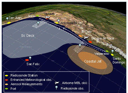
Chilean coastal
component platforms and instrumentation
A comprehensive
near-coastal sampling strategy is planned for October 2007, which includes
atmospheric thermodynamic and dynamic measurements with a light aircraft (Chilean
AirForce Twin Otter), a Chilean Servicio
Hidrográfico y Oceanográfico
de la Armada de Chile (SHOA) research vessel, an elevated land site at a site,
El Tofo, on the Chilean coastal range to measure
cloud and aerosol microphysical properties, and enhanced meteorological
observations at sites along the Chilean seaboard. Funding for most of these activities will be
requested from FONDECYT, the Chilean science funding agency, with support from
the Chilean Airforce (Twin Otter). Table 4 provides
details of the instrumentation for this component of VOCALS-REx.
Table 4: Chilean VOCALS-REx coastal component
platforms and instrumentation
|
Platform |
Instruments |
Observations |
Contact |
|
Chilean Airforce
Twin Otter aircraft |
AIMMS20 AQ instrument suite |
Temperature, humidity, winds,
turbulence |
Gallardo (Universidad de Chile) |
|
SHOA R/V Atmosphere |
Radiosondes, surface
meteorological package, NOAA wind profiler |
MBL structure and dynamics |
Rutllant/Garreaud
(Universidad de Chile) |
|
SHOA R/V Ocean |
CTD-O, ADCP and thermo-salinograph, water sampling |
Upper ocean physical and chemical
structure |
Pizarro
(Universidad de Concepcion) |
|
El Tofo (land site) |
Counterflow virtual
impactor (CVI), bulk filter measurements,
Differential mobility analyzer (DMA) |
Cloud and aerosol size
distribution and chemical properties, cloud droplet residual properties |
Gallardo (Universidad de Chile)
and Krejci (MISU, |
|
Modeling |
PSU/NCAR MM5 regional atmospheric
model |
MBL/coastal jet structure and
variability, diurnal subsidence wave generation |
Garreaud
(Universidad de Chile) |
Peruvian coastal
component platforms and instrumentation
As
part of the international contribution to VOCALS-REx, a group of Peruvian
researchers are proposing a set of enhanced atmospheric measurements and an
oceanographic/atmospheric coastal cruise with the Peruvian research vessel. The
suite of measurements is given in Table 5. The primary contribution to
VOCALS-REx will consist of a 30 day cruise organized by the Instituto del Mar del Perú (IMARPE) to sample oceanography and meteorology along
the Peruvian coastal zone from 4-18°S. It is also planned to request the NSF
Deployment Pool 915 MHz wind profiler and Radio Acoustic Sounding System (RASS)
on the cruise which to provide high time resolution profiling observations of
the horizontal wind and virtual temperature in the marine boundary layer and
lower free troposphere. The wind profiler is also sensitive to
precipitation-sized hydrometeors in low clouds, and will be used to
characterize the occurrence of drizzle falling from the near-coastal
stratocumulus clouds.
Table 5: Peruvian VOCALS-REx coastal component
platforms and instrumentation
|
Platform |
Instruments |
Observations |
Contact |
|
IMARPE R/V |
Surface meteorological suite, wind
profiler, 6 hourly radiosondes, CTD ocean profiling, Acoustic
Doppler Current Profiler (ADCP) |
Surface meteorology, SST, bulk
fluxes, MBL wind and turbulence profiles, tropospheric
structure Upper ocean currents, temperature
and salinity profiles |
Silva Instituto
del Mar del Perú (IMARPE) |
|
NSF Deployment Pool 915 MHz wind profiler, radio acoustic
sounding system (RASS) |
Horizontal and vertical winds,
turbulence, virtual temperature profiles |
Takahashi/Wood ( |
|
|
Enhanced met sites |
Tethered balloon, automatic
weather stations |
MBL structure and dynamics along
the Peruvian costal zone |
Takahashi
(University of Washington) |
Platform
deployment and sampling strategy
The VOCALS-REx hypotheses
presented above will be tested using carefully designed platform deployment strategies.
Table 6 provides a quick-look summary of how the different platforms and
components discussed above will contribute to the testing of these hypotheses,
with further discussion of the scientific issues and a description of the
testing strategy provided in the Scientific Program Overview document. Here we
describe the specific sampling patterns, including cruise tracks, flights
plans, and coordinated inter-platform activities.
C-130 sampling
strategy
Two distinct primary C-130 flight plans will provide
the range of sampling necessary to address the VOCALS-REx hypotheses. In
addition, subsections of the flights will be used to carry out coordinated
sampling with the RHB and/or the NOAA P3 aircraft, and the C-130 will make some
survey flight legs along the Chilean coast to sample the pollutant outflow at
the start and/or end of the primary missions. The two primary flight plans are
(a) Cross-section missions along the
20°S latitude from the coast to either the RHB or the IMET buoy at 85°W; (b) POCs-drift missions which target either
existing pockets of open cells (POCs) within overcast stratocumulus, or areas
prone to POC development, and track these as they advect with the flow.
Additional flight plans are described at the end of this section.
(a)
Cross-section missions (Fig. 6): These flights are designed to sample
contrasts in MBL thermodynamics, chemistry, aerosols and clouds between the
South American coast and that in the remote SEP. Specific focus will be placed
on good sampling of aerosol characteristics, MBL structure/depth, cloud
morphology, microphysics, and drizzle production (using the University of
Wyoming 94 GHz cloud radar, WCR, on the C-130). These flight
are also extremely useful for airborne cloud remote sensing, and there will be
efforts made to coordinate some of these missions with satellite overpasses,
particularly those of Terra and Aqua/Cloudsat/Calipso
at roughly
An important component of the cross-section missions
is to devote a portion of the flight (typically at least one hour) to
coincident sampling with the RHB. These coordinated sections will serve as a
means of comparing the accuracies of the instruments (particularly aircraft
aerosol sampling and SST estimates) and will provide important in-situ context to remotely sampled cloud
and drizzle properties from the RHB. In addition, these sections will be
invaluable in helping to determine, using a combination of C-130 and C-band
radar measurements, the dynamical structures and mesoscale organization
associated with POCs and mesoscale drizzle cells in general. Planned
coordinated flight sections are described in plan (d) below.
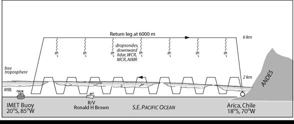
Figure 6: Flight-plan for C-130
Cross-section missions.
(b) POC drift missions (Fig. 7): These flights are designed specifically to
examine microphysical and dynamical processes that occur in pockets of open
cells (POCs) and in the surrounding cloud. POCs that are completely surrounded
by overcast stratocumulus clouds are of the most interest, but broader
boundaries between open and closed cellular convection may also be a focus of
these missions. Of particular importance will be a characterization of the
aerosol and cloud microphysical properties in the two regions. If possible,
these flights will be coordinated with the RHB, whose scanning C-band radar
will provide the mesoscale context for the C-130 data, as well as aerosol and
cloud characterization within the POC region. The idea is to use geostationary
satellite imagery to locate POCs or regions prone to POC formation (using cloud
microphysical retrievals to location regions of unbroken but clean clouds), and
then to target missions accordingly. Once a POC boundary has been reached, the
aim is to carry out across-wind stacks of five straight and level runs
approximately 100 km in length below, in, and above cloud (with additional
porpoising runs to characterize the cloud top and
inversion layers). The aircraft will be allowed to drift with the MBL mean wind
(i.e. with the advecting POC) to provide Lagrangian-type measurements of the
temporal evolution of the POC. Efforts will be made to sample the same POC on
two C-130 flights, or to fly in a POC region that will ultimately advect over
the ship.
The SeaScan
UAV will also be used both in conjunction with C-130 flights and on standalone
missions to determine POC thermodynamic structure. When used in conjunction
with the C-130, it is hoped that the SeaScan will
permit Lagrangian continuity during the daytime between two C-130 night flights
in and around the same POC. The excellent video capability on the SeaScan will be used to determine the boundary between the
POC and the surrounding overcast stratocumulus: profiles and horizontal
sampling legs with the SeaScan will be devised
accordingly.

Figure 7: Lagrangian-type C-130
flight plan for POCs-drift missions.
(c) Coordinated flights with other platforms: There will be
opportunities during VOCALS-REx for periods where the capabilities of the C-130
can be enhanced by coordinated flights in conjunction with the RHB and/or the P3
aircraft. For periods during the cross-section and/or POCS-drift missions we
envisage periods of approximately 2 hours where the platform sampling
strategies can be synchronized.
For the C-130/RHB
combination, the goals will be (i) to intercompare ship and aircraft aerosol measurements in the subcloud region; (ii) to study the structure and dynamics
of the drizzle cells using collocated C-130 data and C-band radar data. The
C-130 will collect in-situ data from drizzling cells in a direction
perpendicular to and parallel to the alongwind RHI
scan line (see below for details of the C-band radar scan strategy). These data
would be used to improve our conceptual model of the physical processes taking
place in the transition from closed to open cells by providing quantitative
measurement of the mesoscale cell structure.
For the C-130/P3
combination, the goal will be to first obtain simultaneous measurements of the
cloud microphysical properties and the subcloud
aerosol properties, and then to simultaneously sample cloud and drizzle
microphysics with the P3 while remotely sensing the cloud from above with the
MCR, AIMR and WCR. These measurements constitute important tests of the aerosol
first and second indirect effects.
(d) Coastal aerosol
survey legs: When time permits at the start or end of flights, we hope to
carry out 2-3 legs and vertical profiles in a roughly north-south direction
along the Chilean coast at different altitudes to sample the chemical and
aerosol characteristics of the airmass advecting from
Table 6a: Contribution of different
observational platforms to testing of Aerosol-Cloud-Drizzle hypotheses
|
Hypothesis |
NSF
C-130 |
NOAA
RHB |
NOAA
P3 |
El.
Tofo |
|
1a: Variability in the
physicochemical properties of aerosols has a measurable impact upon the
formation of drizzle in stratocumulus clouds over the SEP. |
In-situ aerosol, cloud and drizzle
microphysical measurements from cross-section and POCs-drift flight patterns WCR drizzle rate estimates |
Near-continuous aerosol sampling over 35
day period at a range of distances from the coast Cloud and drizzle remote sensing |
Aerosol and cloud microphysical
measurements |
Chemistry of aerosols and cloud droplet
residuals at continental outflow site |
|
1b:Precipitation is a necessary condition for the
formation of pockets of open cells (POCs) within stratocumulus clouds. |
Detailed Lagrangian observations of the
evolving cloud and precipitation structure within POCs |
Simultaneous observations of precipitation
and cloud structure as POCs advect over the ship. |
Sampling of the aerosol and cloud
properties in POCs and surrounding cloud |
N/A |
|
C-130 and/or P3 flights coordinated with
RHB C-band radar to observe mesoscale dynamics of drizzle cells |
||||
|
1c: The small effective radii
measured from space over the SEP are primarily controlled by anthropogenic,
rather than natural, aerosol production, and that entrainment of polluted air
from the lower free-troposphere is an important source of cloud condensation
nuclei (CCN). |
DMS and SO2 chemistry, aerosol
chemical composition, cloud microphysical measurements, MCR/AIMR remote
sensing Entrainment fluxes of aerosols and
precursors using DMS/turbulence measurements |
DMS and SO2 chemistry, aerosol
chemical composition, remotely sensed cloud microphysics during daytime |
Aerosol chemical composition, horizontal
gradients in cloud microphysics |
Cloud microphysical measurements and
aerosol source attribution |
|
1d: Depletion of aerosols by coalescence
scavenging is a major sink term for cloud condensation nuclei over the SEP. |
WCR precipitation and Lagrangian-type
sampling of evolving aerosol population. Eddy correlation aerosol and cloud
droplet flux measurements to close CCN budget |
Simultaneous in-situ aerosol and C-band
precipitation estimates |
N/A |
N/A |
Table 6b:
Contribution of different platforms to testing of Coupled Ocean-Atmosphere-Land
hypotheses
|
Hypothesis |
C-130 |
RHB |
Chilean coastal |
Peruvian coastal |
|
2a: Oceanic
mesoscale eddies play a major role in the transport
of heat and fresh water from coastally upwelled
water to regions further offshore. |
N/A |
Upper ocean butterfly pattern sampling
with SeaSoar, ADCP, XBTs |
Upper ocean spatial sampling in eddy-generation
zone |
Upper ocean spatial sampling in
eddy-generation zone |
|
2b: Upwelling, by changing the
physical and chemical properties of the upper ocean, has a systematic and
noticeable effect on aerosol precursor gases and the aerosol size distribution
in the MBL over the SEP. |
Atmospheric DMS/SO2
measurements, mesoscale variability in SST, surface DMS fluxes, and aerosol
physicochemical properties |
Surface DMS fluxes. Simultaneous measurement
of mesoscale ocean eddies, nutrients, DMS, and aerosols |
Contextual information on the variability
and strength of coastal upwelling |
Contextual information on the variability
and strength of coastal upwelling |
|
VOCALS modeling will be used to test
aspects of this hypothesis by incorporating the relevant physical and
chemical processes into the modeling framework. |
||||
|
2c: The depth, phase speed, and
vertical structure of the diurnal subsidence wave (“upsidence
wave”) originating on the |
Atmospheric structure in the vertical
plane along wave propagation direction from cross-section flights at
different phases of the diurnal cycle |
Continuous sampling of lower troposphere (rawinsondes,
clouds, surface meteorology) over several days along 20°S latitude at 77.5°W
and 85°W |
Diurnal sampling of winds and free-tropospheric structure using R/V in near-coastal region |
Diurnal sampling of winds and free-tropospheric structure using R/V in near-coastal region |
Table 6c: Contribution of different platforms to evaluation of
satellite cloud remote sensing issues
|
Can satellite
estimates of stratocumulus cloud microphysical properties (e.g. effective
radius or cloud droplet number concentration from MODIS) and precipitation
(from CloudSat or MODIS) be refined to perform in a
satisfactory manner even under conditions of broken cloudiness on the pixel
scale? |
NSF
C-130 |
NOAA
RHB |
NOAA
P3 |
|
Airborne remote sensing at similar
wavelengths to satellite instruments but at much higher spatial resolution. Near
coincident in-situ cloud microphysical and drizzle measurements for
validation |
Continuous remotely sensed cloud and
precipitation measurements for direct satellite evaluation |
Airborne microwave and broadband fluxes
with near coincident in-situ cloud microphysical and measurements for
validation |
|
|
Coordinated stacked C-130 and P3 flights
over the ship for simultaneous in-situ
cloud microphysics and remote sensing from above (C-130) and below (P3 and
RHB) cloud Flights coordinated with satellite overpasses
where possible |
|||
RHB deployment
strategy
The RHB will provide critical oceanographic and
atmospheric measurements in VOCALS-REx. The RHB cruise track is shown in Fig. 8
and consists of a 35 day period on task (with approximately 10 days of transit
for a total of 45 days requested). The deployment strategy consists of two
stationary extended measurement periods of 6 days each at 20°S, 85°W and
at 20°S, 75°W (where maintenance work will be carried out on the instrumented
IMET and SHOA buoys). Continuous sampling of DMS and SO2, aerosols,
meteorology, vertical atmospheric structure, and remotely sensed cloud and
drizzle properties will take place during the stationary periods.  In addition to the stationary periods, the RHB will
carry out two ocean mesoscale survey butterfly patterns 500 km on a side
at a speed of 8 kts. The butterfly patterns,
centered on the IMET buoy at 20°S, 85°W and on 20°S, 77.5°W respectively, will
be used to sample the mesoscale structure of the upper ocean including
obtaining high vertical and horizontal resolution sampling of the upper
100 m of ocean using the SeaSoar vertical
profiler towed behind the RHB. The total duration for each butterfly pattern is
approximately 7 days. The butterfly patterns are a larger version of those used
to effectively and efficiently sample mesoscale variability and eddy structure
in the upper ocean during the Intertropical
Convergence Zone component of the East Pacific Investigation of Climate field
program in 2001.
In addition to the stationary periods, the RHB will
carry out two ocean mesoscale survey butterfly patterns 500 km on a side
at a speed of 8 kts. The butterfly patterns,
centered on the IMET buoy at 20°S, 85°W and on 20°S, 77.5°W respectively, will
be used to sample the mesoscale structure of the upper ocean including
obtaining high vertical and horizontal resolution sampling of the upper
100 m of ocean using the SeaSoar vertical
profiler towed behind the RHB. The total duration for each butterfly pattern is
approximately 7 days. The butterfly patterns are a larger version of those used
to effectively and efficiently sample mesoscale variability and eddy structure
in the upper ocean during the Intertropical
Convergence Zone component of the East Pacific Investigation of Climate field
program in 2001.
Atmospheric measurements will be made continuously
during the butterfly patterns, but caution will be taken to screen the data for
times when the ship exhaust could be sampled by the chemical and aerosols instrumentation.
The orientation of the butterfly patterns is chosen to provide legs in the
across and downwind directions (these are also parallel and perpendicular to
the direction of the mean surface currents). Because the cloud and drizzle
structures advect with the mean wind (typically 6-10 m s-1
from the ESE), their evolution can only be tracked for roughly 1.5-2 hours with
the C-band radar on a stationary ship. The downwind legs therefore allow us to
track drizzling cells for almost twice as long (3-4 hours) which will provide
important information on the their evolution and longevity. Another advantage
of the chosen butterfly orientation is that the combination of the mesoscale
butterfly surveys centered on 77.5°W and 85°W will result in an almost complete
longitudinal upper ocean cross section from 87.5°W to the Chilean coast.
Figure 8: Track of
the RHB overlaid on SST and surface current field from a regional
eddy-resolving ocean model (ROMS, figure from Penven
et al. J. Geophys. Res., 110, 10.1029/2005JC002945, 2005).
C-Band
radar scan strategy: Because a key
focus of VOCALS-REx is to quantify, and determine the structural properties of
precipitation in and below stratocumulus, it is important to design an
efficient scan strategy for the C-band radar on the RHB. As in the 2001 East
Pacific Investigation of Climate (EPIC) cruise, the C-band radar will conduct
(a) volumetric scans at intervals of 5 minutes using PPIs
at different elevation angles to build up a 3-dimensional volume over a
60 km diameter region centered on the ship; (b) vertical cross sections at
a fixed azimuth angle using (range-height indicators, RHIs)
for improved sampling of the vertical structure of the precipitating cells.
Sector scans using a number of RHIs taken over a
narrow range of azimuth angles may also be used during periods where the C-130
is making measurements around the RHB. These will provide high vertical
resolution sampling of a few drizzle cells where the C-130 is making
simultaneous, collocated in-situ measurements. The combination of the two
platforms sampling the same drizzle cells will provide an unprecedented dataset
on the structure and kinematics of drizzling stratocumulus.
Ocean
mesoscale survey sampling strategy: The
mesoscale survey will use a combination of the SeaSoar
to provide multivariable sawtooth-pattern (series of
slanted profiles) sampling which will capture sharp horizontal gradients
associated with the mesoscale eddies. XBTs will
measure temperature only, but these will provide truly vertical profiles with a
vertical resolution higher than that of the SeaSoar
approximately every 50 km along the butterfly pattern. The ADCP will be
used to provide vertical profiles of the current velocity continuously which
are corrected for ship motion using a sophisticated Ashtech
GPS system. The ADCP data will be used in conjunction with both the SeaSoar and the XBT data to examine the advective
term in the upper ocean heat budget, and also to look for vertical shears
associated with propagating waves and mixing.
NOAA P3 sampling
strategy
The
P3 will primarily be used to sample aerosols and cloud microphysical properties
during VOCALS-REx. Satellite data and forecast fields from numerical models
will be used to plan flights, and these plans chiefly aim to sample strong
gradients in cloud microphysical properties in regions where there are only
weak or no corresponding gradients in the large scale meteorology, to ascertain
the potential strengths of the aerosol indirect effects upon the cloud radiative
properties. As with the C-130 the P3 is expected to have capability for making
remote sensing measurements, and so flight legs will be carried out below, in,
and above cloud. Coordinated flights with both the C-130 and the RHB are also
envisaged (See C-130 flight plan (c) above).
VOCALS-REx Coastal
component sampling
The near coastal oceanographic and atmospheric
sampling during VOCALS-REx, including measurements from land sites, will
largely be carried out by research groups from
 The oceanographic aims of the VOCALS-REx coastal
component are to improve our understanding of the structure and spatial
variability of the Humboldt current system along the
west coasts of
The oceanographic aims of the VOCALS-REx coastal
component are to improve our understanding of the structure and spatial
variability of the Humboldt current system along the
west coasts of
 Particular
sections of this coastline, most notably southern Peru (at 15°S) and central Chile
(30-40°S) exhibit particularly strong ocean eddy activity and the cruise data
will be used to examine how these features affect the MBL and cloud structure
using wind profiler, radiosondes, and thermodynamic data from the cruises. In
addition, the Chilean Airforce Twin Otter will be
used to sample the near-coastal marine boundary layer, in particular to examine
the structure and variability of the coastal low level jet that forms at the
location of the peak in ocean eddy kinetic energy along the Chilean coast. The
air-sea interactions between the oceanic eddy structure and the strength of the
coastal jet will be explored using the cruise and the airborne data. The MM5
regional atmospheric model will be run for the VOCALS-REx period and will be
used to examine aspects of the interactions of the coastal jet with the cloud
and MBL structure, and to examine the factors controlling the diurnal
subsidence wave generated along the west Andean slopes of
Particular
sections of this coastline, most notably southern Peru (at 15°S) and central Chile
(30-40°S) exhibit particularly strong ocean eddy activity and the cruise data
will be used to examine how these features affect the MBL and cloud structure
using wind profiler, radiosondes, and thermodynamic data from the cruises. In
addition, the Chilean Airforce Twin Otter will be
used to sample the near-coastal marine boundary layer, in particular to examine
the structure and variability of the coastal low level jet that forms at the
location of the peak in ocean eddy kinetic energy along the Chilean coast. The
air-sea interactions between the oceanic eddy structure and the strength of the
coastal jet will be explored using the cruise and the airborne data. The MM5
regional atmospheric model will be run for the VOCALS-REx period and will be
used to examine aspects of the interactions of the coastal jet with the cloud
and MBL structure, and to examine the factors controlling the diurnal
subsidence wave generated along the west Andean slopes of
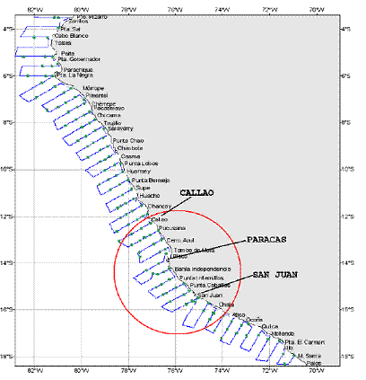
Along the Southern Peruvian coast are regions
(especially 13-17°S) where there is near-permanent stratus cloud clearing. The
structure of the MBL in these regions (area inside red circle in Fig. 10) will
be studied using data from a tethered balloon and from enhanced automatic meteorological
observations along the coastline. The Peruvian 30 day coastal cruise organized
by the Instituto del Mar del Perú (IMARPE)
will provide upper-ocean and lower atmosphere measurements, with focus upon the
southern Peruvian coast. The NSF wind profiler and RASS data will be used to
characterize the MBL structure associated with the coastal jet, and to provide
important data from the lower free troposphere on the diurnally generated
subsidence wave close to the South American coast. These data, together with
wind profiler data from the Chilean coastal cruise will provide information on
the geographical structure of the diurnal subsidence wave.
Atmospheric aerosol, chemistry, and cloud
measurements will be carried out at an elevated site (850 m amsl) in the Chilean coastal range at El Tofo (29.5°S, 71°W). El Tofo is
well positioned to sample the airmass leaving
In addition to the El Tofo site, the NSF C-130 will sample low level and elevated
pollution layers in the coastal region of northern