|
ROBERT
WOOD |
|
Group
[Multisensor Midlatitude Cyclones dataset] Research tools And the rain tossed about us |
|
|
|
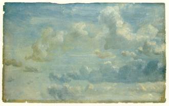
John Constable,
Cloud Study (1822) Fractal
low clouds over the
observed from space
with MODIS (2004)
[image courtesy of NASA]
|
|
|
|
Clouds have fascinated
us for thousands of years. Behind their natural beauty lies a tremendous
complexity that continues to elude complete theoretical understanding. The
fundamental role that clouds play in the Earth’s climate system means
that it is important that we search for better ways to understand and
describe the processes than control their formation, maintenance, and
dissipation. From submicron-sized cloud condensation nuclei activated in
seconds, to cloud systems spanning thousands of kilometers and lasting several
days, cloud processes span an enormous range of temporal and spatial scales.
Furthermore, the ability to better understand the behavior of clouds requires
novel combinations of knowledge drawn from the forefront of physics,
chemistry and mathematics.
Clouds over
the
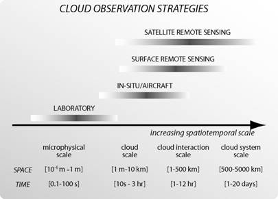
The large range of
scales makes the observation and measurement of clouds a particularly
challenging problem. No one measurement system can provide a complete
observational picture of cloud processes. The major goal of my research is to
use observational datasets in novel ways to examine the structural and
behavioral properties of cloud systems and the underlying meteorology
controlling them. Simple model frameworks are used to assist in the
distillation of observational datasets and to develop a quantitative basis
for understanding. Increasingly, it is through the combination of
observational datasets from more than one platform that the greatest strides
in our understanding are taken.
Specific
projects being undertaken at present are:
1. Synthesis of observational datasets
and modeling to improve our understanding and parameterizations of boundary
layer clouds over the southeast
This work is coordinated by the VOCALS Science Working Group (C. Roberto Mechoso - chair, Chris Bretherton, Barry Huebert, Bob Weller, Robert Wood)
and with VOCALS scientists in the US and abroad. We expect that many opportunities for graduate students to become involved in this work
will be available at the participating institutions. VOCALS is primarily supported by grants from NOAA and NSF.
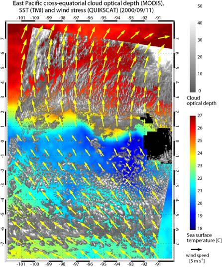
2. Exploring the links between cloud
structure and meteorology over the oceans. Data from the Moderate
Resolution Imaging Spectroradiometer (MODIS) and other satellites are being
used to investigate cloud structural properties (cloud optical thickness and
cloud top height) of cloud ensembles over the warm regions of the tropical
oceans. Many questions concerning these clouds remain unanswered: what are
the relative importances of the local SST and
horizontal gradients of SST in determining the cloud ensemble properties in
the tropics? Is the observed cancellation between shortwave and longwave cloud forcing (SWCF and LWCF) over the tropical
warm pool fortuitous or the result of physical feedbacks? Over what temporal
and spatial scales does this cancellation occur? How do tropical clouds
respond to climate change? What are the interactions between deep convection
and the structure of the tropical tropopause? How will low clouds change under a changed climate? We
are addressing these questions using multiplatform observational datasets.
This work is being carried out with Dennis Hartmann, Terry Kubar, and Jian Yuan at UW, and
is funded by NASA.
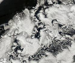
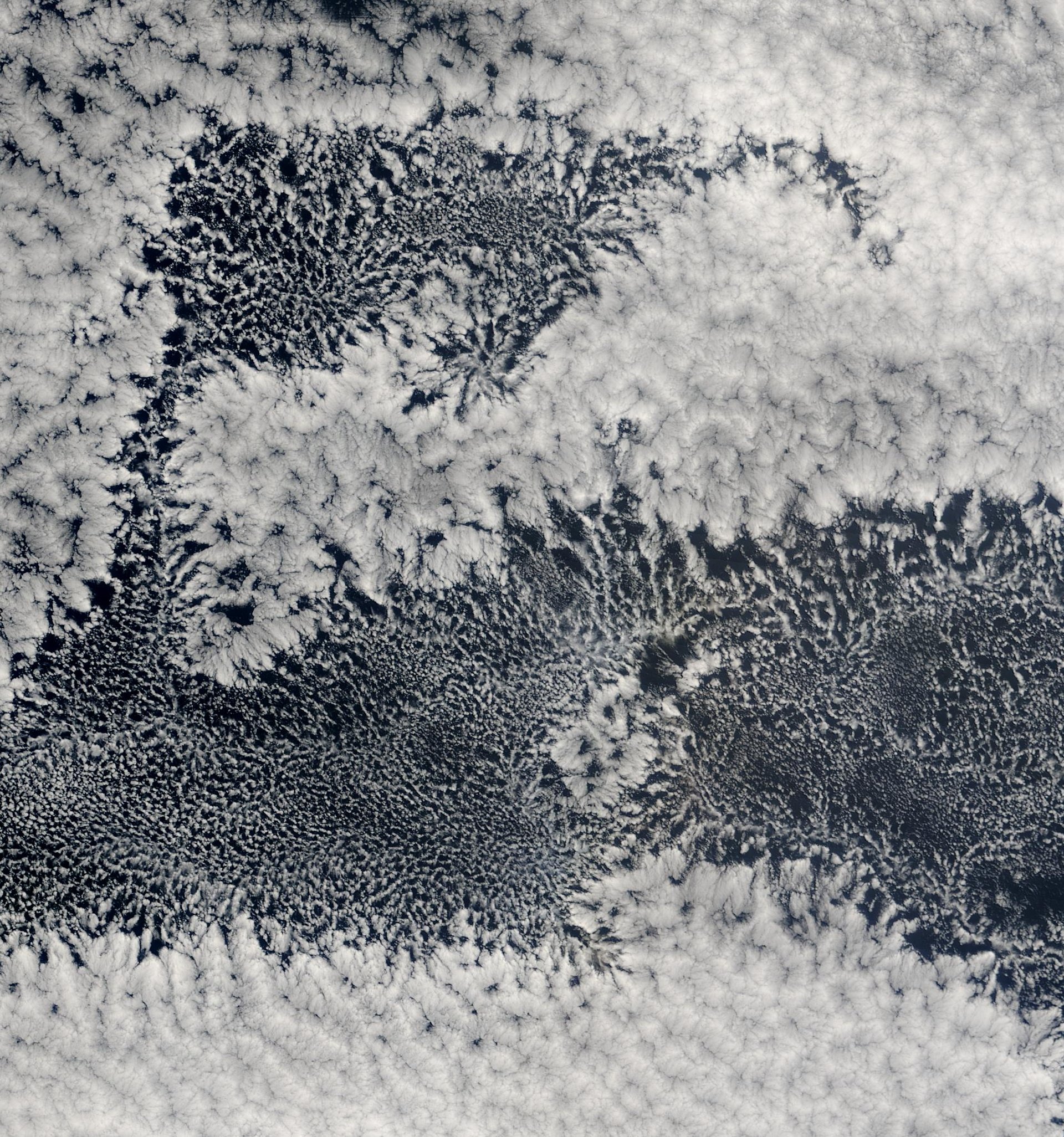
Mesoscale cellularity in marine stratocumulus clouds. Open and closed mesoscale cellular convection are the dominant
forms of organization of low clouds over the remote eastern oceans, but an understanding of the physics of these
mesoscale systems continues to be elusive. This MODIS image (approximately 800 km across) shows the sharp transitions that
occur between the closed and open cells, which observations suggest may be driven by precipitation.
3. The Marine Stratocumulus Cloud System (MSCS) is an interconnected
ensemble of marine boundary layer clouds in which both radiation and precipitation work together to provide the key forcings
on the marine boundary layer (MBL). Sometimes, most commonly when these systems move within roughly 500 km of coastlines, the MSCS
can become perturbed by ingesting cloud condensation
nuclei from continental sources. This can alter their structure and dynamics in ways that are barely understood.
The hypotheses that precipitation can be an important
component of the mesoscale and turbulent dynamics of these systems are supported by the few studies
that have well-documented the MSCS boundary layer.
My aim is to assist in the pursuit of understanding the MSCS system.
The importance of the MSCS over the global oceans is
rarely disputed, but remoteness is at the heart of the sampling problem. Radars need to be designed to sample these clouds, and
these radars need first-class sampling platforms, on ships, on aircraft, and in space. More effort needs to be spent in learning
how to better coordinate and retrieve information from our satellite missions to sample these clouds,
and in devising ways to incorporate this data into our
numerical models. GPS provides a wonderful, as yet largely untapped, opportunity for sampling the MBL thermodynamic structure, and should be
invested in. Scatterometry is our only true spaceborne dataset to sample lower atmosphere dynamics, and should not be neglected. CloudSat and CALIPSO
are providing an unprecedented dataset on the properties and organization of the precipitation and cloud structure in MSCS, and the phalanx of
colocated instruments on the other A-train satellites is providing the essential context for these groundbreaking measurements. The VOCALS Program and VOCALS Regional Experiment (REx) will provide important new datasets for the understanding of the MSCS.
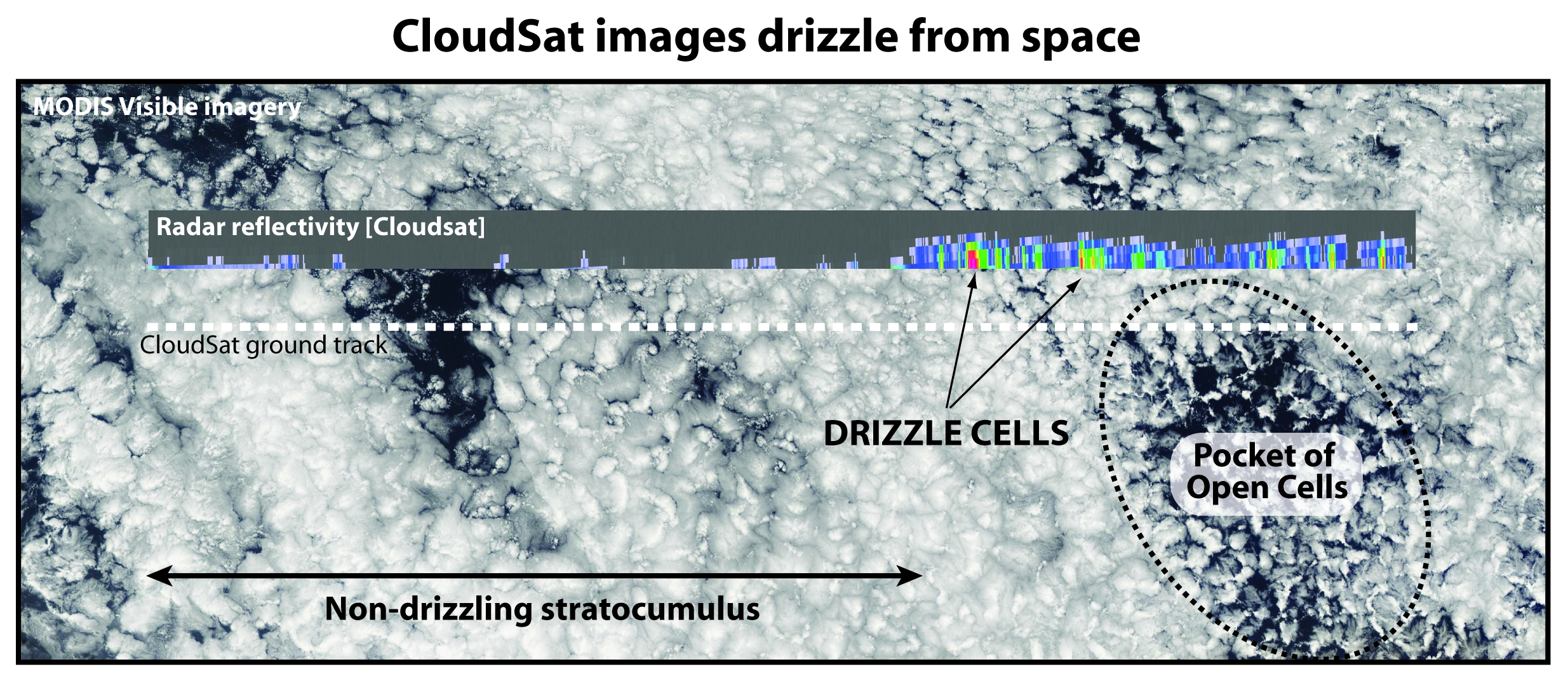
CloudSat's sensitive radar is able to detect precipitation from shallow marine clouds below 1.5 km. The data shown above
are from September 9th 2006 over the cool waters of the Southeast Pacific Ocean where stratocumulus clouds organize
into the largest sheet of such clouds on the planet. Prior to the launch of CloudSat, the precipitation (typically in the form
of drizzle) falling from these cloud systems was undetectable from space. It is now becoming clear that precipitation has a
profound impact upon the structure, dynamics and coverage of marine stratocumulus. CloudSat will provide important
insights into the role of precipitation in stratocumulus cloud systems over the remote ocean.
4. Precipitation error characterization over the
global oceans. Microwave estimates of precipitation from satellites such as
SSM/I, TRMM, and AQUA form the basis for our understanding of oceanic
precipitation processes. These estimates are indirect and are the focus of
considerable efforts to improve them. Our approach is to construct novel
methods to compare the microwave estimates with those from spaceborne radar
(TRMM Precipitation Radar and, in future, the Global Precipitation Mission
dual-wavelength radar) and ground based radar (Kwajelein) using
regime-dependence of precipitation structure as a physical basis for
compositing. This work is conducted in collaboration with Sandra Yuter, Daniel
Horn (
|
|
|
|
|
|
|