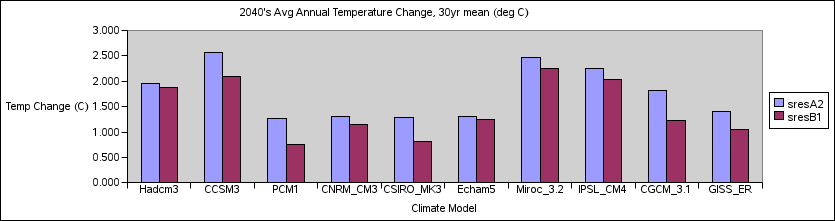
Temperature changes, relative to 2000, for each model based on a centered 30-year means to the simulated regional average.
For all climate model data analysis, regional boundaries are the following: latitude: 42-49 N longitude: 111-124 W
Summer is defined as June, July and August (JJA), while winter is December, January, February (DJF). 'winter' of a given year includes dec of the previous year).
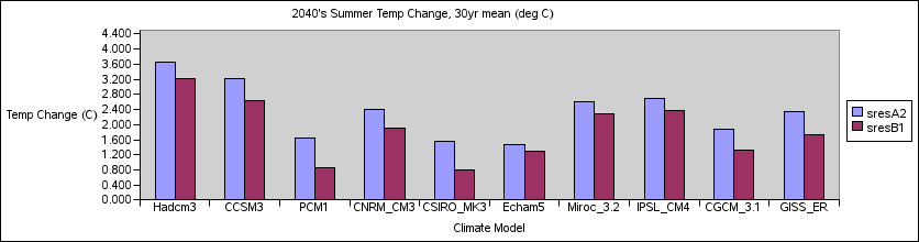

| Model | A2 Annual | B1 Annual | A2 JJA | B1 JJA | A2 DJF | B1 DJF |
|---|---|---|---|---|---|---|
| Hadcm3 | 1.964 | 1.874 | 3.668 | 3.208 | 1.109 | 0.939 |
| CCSM3 | 2.573 | 2.101 | 3.232 | 2.645 | 1.984 | 2.061 |
| PCM1 | 1.272 | 0.760 | 1.651 | 0.860 | 1.189 | 0.581 |
| CNRM_CM3 | 1.311 | 1.150 | 2.401 | 1.918 | 0.823 | 0.911 |
| CSIRO_MK3 | 1.281 | 0.817 | 1.543 | 0.805 | 0.965 | 0.642 |
| Echam5 | 1.317 | 1.240 | 1.479 | 1.287 | 1.790 | 1.366 |
| Miroc_3.2 | 2.465 | 2.250 | 2.611 | 2.276 | 2.442 | 2.335 |
| IPSL_CM4 | 2.254 | 2.031 | 2.696 | 2.387 | 2.380 | 2.168 |
| CGCM_3.1 | 1.827 | 1.228 | 1.866 | 1.332 | 2.219 | 1.650 |
| GISS_ER | 1.403 | 1.061 | 2.352 | 1.724 | 0.839 | 0.753 |