Scientific issues and hypotheses to be tested
The climate of the SEP is dependent upon important interactions and feedbacks between the upper ocean, the Andes mountains, and the lower troposphere. Studies using coupled ocean-atmosphere general circulation models (Ma et al. 1996, Gordon et al. 2000) have clearly demonstrated that the accurate prediction of the optical properties of low clouds over the SEP is an essential requirement for driving strong trade winds and producing the observed SST distribution. Richter and Mechoso (2005) demonstrate that the great height and extent of the Andes mountains markedly increases the lower tropospheric static stability over the SEP, enhancing the cloud cover. The Andes mountains also encourage the formation of a near-coastal jet in the marine boundary layer (MBL) that enhances the oceanic upwelling of cold water (Garreaud and Muñoz 2005). Mountain effects on the monsoon circulations over the continents drive stronger subtropical gyres, which increase the evaporative cooling of the surface and further reduce SST (Kitoh 2002). The coastal upwelling associated with the Humboldt Current system is not only important in the coastal zone, but also impacts the SST much further offshore through ocean transport processes that include mesoscale eddy transport (Penven et al. 2005, Colbo and Weller 2006). The climate of the SEP region is therefore a tightly coupled system involving interactions between the ocean, the atmosphere, and the land. The SEP climate system is unique in that its ocean current system is directly connected with the tropical ocean (Lukas 1986) and so is subject to strong ENSO variability. In addition, there is modeling evidence that global climate and particularly tropical precipitation is affected by the western boundary of subtropical South America. The SEP is poorly explored observationally, and our ability to make accurate predictions of the tropical climate is strongly sensitive to its representation in numerical models (Yu and Mechoso 2001).
In addition to responding to large scale dynamics, cloud optical properties over the SEP are also affected by atmospheric aerosols (Bretherton et al. 2004), with contributions from both natural and anthropogenic sources. Figure 2 shows that cloud droplet effective radii are low off the coast of Northern Chile, implying elevated concentration of cloud droplets. These elevated concentrations are directly downwind of major copper smelters whose combined sulfur emissions total 1.5 TgS yr-1, comparable to the entire sulfur emissions from large industrialized nations such as Mexico and Germany. The smaller droplet effective radii increase the reflected solar radiation, and estimates of the component of the TOA solar radiation due to geographic variability in effective radius alone are as high as 10-20 W m-2 or 15% of the mean (Fig. 2). The magnitude of these estimates is such that the indirect effects of aerosols on clouds could lead to significant decreases in the amount of solar radiation entering the ocean, with significant implications for the ocean heat budget.
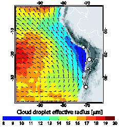
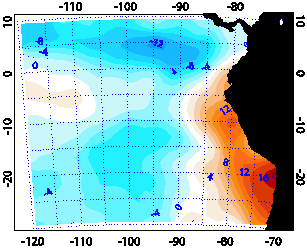
Figure 2: Left: Austral spring season (SON) mean cloud droplet effective radius from MODIS; mean surface winds from Quikscat. Locations of the major copper smelters in the region are shown as white circles (relative area proportional to their expected sulfur emissions). Right: Component of SON shortwave cloud forcing [W m-2] due to geographic variations in effective radius, inferred from MODIS.
There is also evidence from the recent East Pacific Investigation of Climate (EPIC) field study (Bretherton et al. 2004) that drizzle formation, enhanced by the depletion of aerosols in the clean MBL, can drive remarkably rapid transitions which drastically reduce cloud cover (Stevens et al. 2005). It is clear therefore that low clouds and the dynamical and microphysical processes controlling their thickness and coverage are a lynchpin in the climate of the SEP. However, our knowledge of clouds in this region is so far limited to surface and spaceborne remote sensing. There are no in-situ observations of these clouds with which to test hypotheses concerning their physics and chemistry.
The maintenance of the SST distribution over the SEP, and the eastern ocean basins in general, is an important unresolved problem. Satellite altimetry, SST maps, and regional ocean model studies all reveal that mesoscale ocean eddies 50-200 km across can affect the SST well offshore by fluxing cold water out from the coastal upwelling regions. Through their nutrient content, eddies could also impact the ocean-atmosphere flux of dimethylsulfide (DMS), and important aerosol precursor gas. The heat flux divergence by mesoscale eddies may account for roughly 40 W m-2 net heat flux into the ocean over the remote SEP. Mesoscale ocean eddies are poorly observed and understood, and are barely resolved in coupled ocean-atmosphere climate models.
VOCALS-REx will provide intensive observations of key processes contributing to the climate of the SEP. The observations will be used to test a coordinated set of hypotheses, to help validate satellite retrievals, and to evaluate our ability to model the important physical and chemical processes in the SEP. The VOCALS-REx hypotheses are organized into two broad categories: (1) testing hypotheses related to the impacts of aerosols upon the microphysical and structural properties of stratocumulus clouds and drizzle production; (2) testing hypotheses related to the coupled ocean-atmosphere-land system. The hypotheses are as follows:
- TESTING AEROSOL-CLOUD-DRIZZLE HYPOTHESES
- Variability in the physicochemical properties of aerosols has a measurable impact upon the formation of drizzle in stratocumulus clouds over the SEP.
- Precipitation is a necessary condition for the formation of pockets of open cells (POCs) within stratocumulus clouds.
- The small effective radii measured from space over the SEP are primarily controlled by anthropogenic, rather than natural, aerosol production, and that entrainment of polluted air from the lower free-troposphere is an important source of cloud condensation nuclei (CCN).
- Depletion of aerosols by coalescence scavenging is necessary for the maintenance of POCs.
- TESTING COUPLED OCEAN-ATMOSPHERE-LAND HYPOTHESES
- Oceanic mesoscale eddies play a major role in the transport of heat and fresh water from coastally upwelled water to regions further offshore.
- Upwelling, by changing the physical and chemical properties of the upper ocean, has a systematic and noticeable effect on aerosol precursor gases and the aerosol size distribution in the MBL over the SEP.
- The depth, phase speed, and vertical structure of the diurnal subsidence wave (“upsidence wave”) originating on the Andes slopes in northern Chile/southern Peru is well predicted using regional model simulations.
An additional key VOCALS-REx goal is to use the observational datasets to critically evaluate the accuracy of current and future satellite cloud microphysical retrieval algorithms. These measurements are central to our understanding and quantification of the indirect effects of aerosols upon clouds and the climate system.
The following sections detail the scientific rationale behind the hypotheses and describe how they will be tested using the intensive field observations.
2.1 Aerosol-cloud-drizzle interaction hypotheses
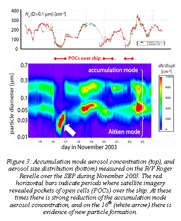 Shipborne surface remote sensing observations over the SEP made during the 14 day EPIC 2001 field campaign (Bretherton et al. 2004) provide some initial evidence that drizzle production may be stronger during periods of reduced cloud droplet number concentration. Precipitation, even the low rates associated with drizzle, can exert a powerful influence on the structure, thickness, and coverage of marine stratocumulus, and is hypothesized to be a powerful mechanism by which aerosols can impact the radiative balance of the earth (Albrecht 1989). Observations and theory suggest that variability in cloud droplet concentration in marine stratocumulus is largely driven by variability in the concentration of accumulation mode aerosol particles (e.g. Twomey and Warner 1967, Martin et al. 1994, Breon et al. 2002). There are reasons to believe that both natural and anthropogenic sources of aerosols are important in the SEP region. The few existing in-situ measurements of SEP aerosol physicochemical properties were taken on recent buoy maintenance cruises by Don Collins, Chris Fairall and coworkers. These reveal that aerosols in the MBL are predominantly composed of soluble materials, and are strongly bimodal in nature with an accumulation mode concentration (the particle mode that constitutes the majority of cloud condensation nuclei CCN) that is highly variable in time and space (Fig 3). As far as 1000 km from the coast concentrations vary from 20-300 cm-3 with even higher values of up to 500 cm-3 nearer the Chilean coast. This suggests that the MBL over the SEP experiences periods of extremely clean and quite heavily polluted air. This, coupled with the extensive cloud coverage during the Austral spring, indicates that the SEP is an ideal test-bed for investigating the indirect effects of aerosols on clouds. Investigation of the influences of aerosol physicochemical properties on cloud microphysics and drizzle production is a key goal of VOCALS-REx.
Hypothesis 1a: Variability in the physicochemical properties of aerosols has a measurable impact upon the formation of drizzle in stratocumulus clouds over the SEP
Testing strategy: Data from two platforms will be used to test H1a: the NOAA R/V Ronald H Brown (RHB) and the NSF C-130 aircraft. Both the RHB and the C-130 will be equipped with instrumentation necessary to provide a comprehensive suite of aerosol and aerosol precursor physicochemical measurements. The C-130 will characterize cloud and drizzle microphysics using in-situ microphysical measurements and the Wyoming Cloud Radar (WCR) will be flown to obtain remotely sensed drizzle profiles. The RHB will make continuous remotely sensed measurements of cloud physical properties including cloud base, cloud top and liquid water path, in addition to a set of in-situ aerosol microphysical measurements similar to those on the C-130. Cloud microphysical measurements will be obtained from the RHB using transmissivity-based retrievals. The RHB C-band scanning radar will provide essential measurements of the horizontal and vertical drizzle structure, while a combination of vertically pointing 35 GHz radar and lidar will provide estimates of the drizzle size distributions over the ship. It is hoped that on at least half of the C-130 flights there will be an opportunity for the C-130 and RHB to provide collocated measurements. This combination of remotely sensed and detailed in-situ measurements will provide an unprecedented characterization of the microphysical and macrophysical structure of drizzling stratocumulus. The month-long RHB dataset will add valuable context to the detailed, but limited temporal sampling from the C-130.
Tantalizing observational evidence suggests a direct link between drizzle and cloudiness in MBL clouds that is manifest through regions of broken cloud organized into roughly polygonal lattices, called open cellular convection, embedded within otherwise overcast stratocumulus that tends to be organized in the form of closed mesoscale cellular convection. These regions have been termed POCs, or “pockets of open cells” (Stevens et al. 2005); the satellite image in Fig. 4 includes some examples.
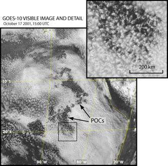
Figure 4: GOES visible-wavelength satellite image showing extensive stratocumulus cloud cover over the SEP, with embedded regions of broken cloud cover called ‘pockets of open cells’ (POCs). The inset zooms in on the black square, which includes one such POC (from Bretherton et al. 2004). Are these two states evidence of microphysical bistability in the MBL?
The formation of POCs occurs most frequently at night (Wood et al. 2006), and can occur with surprising rapidity. Following the initial formation, the POC can grow, but the basic open cellular structure within it tends to persist for several days. This supports the notion that there are two relatively stable states for the structure of low cloud over the SEP (e.g. Fig. 4). Theoretical work suggests that such bistability may be microphysically driven (Baker and Charlson 1991), but this is untested observationally. Qualitative observations using satellites suggest that a large fraction of the subseasonal variability in SEP cloud cover can be explained by the transition from closed to open cellular convection; this strongly motivates the need to better understand POC formation and maintenance. Recent work using a synthesis of satellite observations and reanalysis data suggests that large scale meteorological factors may not be the driving force behind the transition (Wood and Hartmann 2006), and that processes internal to the MBL may be responsible. The few case studies to date suggest that POCs are often associated with low aerosol concentration (Petters et al. 2004, Sharon et al. 2006, Wood et al. 2006), and intense drizzle production (Stevens et al. 2005, VanZanten et al. 2005, Comstock et al. 2005). Figure 3 demonstrates that near-total depletion of accumulation mode aerosols occurs quite regularly over the SEP and coincides with the presence of POCs.
Further evidence that cloud microphysical changes are associated with POCs emerges from analyses of satellite-derived 3.9-11 mm brightness temperature difference (BTD). For cloudy regions at night, BTD is a good discriminator of cloud droplet size (Perez et al. 2001, Stevens et al. 2005). Low BTD values indicate large cloud droplet sizes which are required to initiate collision-coalescence leading to drizzle. Satellite observations (Wood et al. 2006) indicate that POCs tend to form preferentially in low BTD regions, consistent with the hypothesis that precipitation and POCs are intimately connected.
There is currently no complete conceptual model that satisfactorily describes the POC formation process. By direct aircraft observation of the POCs and the surrounding overcast stratocumulus, we hope to gain an understanding of the role of precipitation in forming and maintaining the structure of POCs, as described below:
Hypothesis 1b: Precipitation is a necessary condition for the formation of pockets of open cells (POCs) within stratocumulus clouds.
Testing strategy: Dedicated C-130 ‘POC-drift’ missions (see the EDO) will be conducted to study the dynamical and microphysical cloud and precipitation in marine stratocumulus. Stacks of flight legs that span the boundary between a POC and the surrounding unbroken stratocumulus will be used to contrast cloud and drizzle microphysics in the two regions. At night, the favorable time for POC formation, satellite 3.9-11 mm BTDs from GOES will be used to locate regions of cloud that are susceptible to POC formation. Flights will be directed according to these forecasts. Ideally, observation of the POC formation process itself is a goal, but much will be learned about their structure by studying existing POCs over an extended time period, and efforts will be made to sample the same POC on two flights, or to fly in a POC region that will ultimately advect over the ship. Aerosondes will also be used both in conjunction with C-130 flights and on standalone missions to determine POC thermodynamic structure. If POCs are observed that do not contain drizzle heavier than a few tenths of a mm day-1 then we can rule out precipitation as being a necessary condition. Based upon our findings from recent cruise data, we expect that drizzle will accompany POCs. If this is the case, then a key goal is to learn the mechanisms by which precipitation affects the mesoscale cloud structure.
Scanning C-band radar observations from EPIC indicate that drizzle cells frequently develop a complex layered mesoscale structure with extensive 5-10 km wide regions flowing into the center of the cells roughly at cloud base with outflow above this. It is an untested possibility that these mesoscale inflow regions are necessary to maintain the moisture supply to the cloud that would otherwise precipitate out within 30 minutes or less. The role of evaporating precipitation is also likely to be important, but evidence linking this with the mesoscale dynamics is so far lacking. The cloud radar on the C-130 will be used in conjunction with the aircraft-derived flight level winds to tease out the mesoscale dynamics of the individual cells within the POC to elucidate the mechanisms responsible for their maintenance and longevity. The scanning C-band radar on the RHB will also provide important information on the horizontal and vertical structure of the POCs, and we plan to obtain at least one POC case where the C-130 and RHB C-band radar will sample the same structures.
The small cloud droplet effective radii observed off the Northern Chilean coast are suggestive of high concentrations of CCN in the MBL, and indeed, aerosol observations (Don Collins, personal communication) from a single cruise leg that passed through this region found a near-coastal peak in accumulation mode aerosols. Volatility measurements on the cruise indicate that the aerosol is primarily composed of sulfur species but this information alone is insufficient to determine the aerosol source. The biologically productive coastal waters that are an important component of the coupled ocean-atmosphere-land climate system in the SEP, are a strong source of dimethylsulfide (DMS, Andreae 1985, Kettle et al. 1999), a critical aerosol precursor gas with a short residence time that oxidizes via two main pathways to form SO2 and the sulfate anion (S(VI)) in the MBL (Charlson et al. 1987, Hobbs 2000). At the same time, emissions inventories (GEIA) indicate strong sulfur sources, primarily from copper smelting, in Northern Chile and Southern Peru. An important aspect is that a significant fraction of these emissions are in the Andean foothills, well above the subsidence inversion. Trajectory analyses and model studies (Gallardo et al. 2002) indicate that this air often moves westward, subsides, and is incorporated into the MBL within a couple of days. This gives us an additional opportunity to attribute high droplet concentrations to aerosols sources using aircraft observations in the free troposphere in conjunction with trajectory analyses. New particles for refilling POCs with CCN could either arrive in this subsiding polluted air or be nucleated in the drizzle-scavenged air from the products of DMS oxidation. Clarke et al. (1999) have observed nucleation in very clean recently-scavenged air just to the north of the VOCALS study area.
Hypothesis 1c: The small effective radii measured from space over the SEP are primarily controlled by anthropogenic, rather than natural, aerosol production, and that entrainment of polluted air from the lower free-troposphere is an important source of cloud condensation nuclei (CCN).
Testing strategy: With observations, in both the MBL and the free-troposphere, of the important aerosol precursor species including DMS, SO2 and MSA, the DMS flux from the ocean surface, in conjunction with the physicochemical aerosol measurements, it will be possible to estimate the relative importance of different pathways for aerosol formation and growth in the MBL, and to attribute the aerosol to specific anthropogenic and natural sources. It is planned to make aerosol size and composition measurements on both the RHB and the C-130 platforms. In addition to the comprehensive aerosol measurement suites that will be carried on the two platforms, both will also have the ability to measure DMS, with the aircraft also estimating entrainment fluxes to characterize the free-tropospheric sources of aerosols and aerosol precursors. Airborne profiles of the SO2 flux will be used to separate entrained vs surface DMS-derived SO2 and associated particles. Aerosol and cloud chemistry measurements will also be made at an elevated land site in the Chilean coastal range downwind of smelters in Northern Chile to determine characteristics of this air before it flows over the SEP, and C-130 flight legs will be dedicated to sampling the characteristics of elevated pollution layers in the free troposphere close to land.
Aerosol-CCN-cloud microphysical closure studies will be carried out using in-situ data from the NSF C-130, to attempt to attribute the variability in cloud droplet concentration (and hence effective radius) to variability in accumulation mode aerosol number concentration and physicochemical properties. Aircraft remote sensing and simultaneous satellite overpasses will also be used to establish the aerosol-cloud microphysical connections.
Numerical models of the aerosol indirect effects (Lohmann and Feichter 1997, Lohmann et al. 2000, Ghan et al. 2001) rely on parameterizations of microphysical processes that are poorly constrained using observations (Lohmann and Feichter 2005). In most of these models, aerosol number concentration is derived chiefly from the aerosol mass. It is becoming evident that even light precipitation can have a marked impact upon the accumulation mode aerosol concentration even if this precipitation evaporates before reaching the surface as recent observations suggest (Comstock et al 2004). Collision-coalescence of cloud and drizzle drops can remove aerosol number concentration (“coalescence scavenging”) without affecting aerosol mass, which can have a major impact upon cloud microphysics in subsequent cloud formation. Simple calculations suggest that coalescence scavenging in aerosol rich plumes in the cloud-topped MBL is independent of the CCN concentration and may deplete CCN on a timescale comparable to the timescale for dilution by entrainment of aerosol-poor free tropospheric air. These results suggest an important role for coalescence scavenging in limiting the geographical extent to which pollution can travel over the oceans when low cloud is present, which needs to be accurately parameterized if the regional indirect effects of aerosols on the climate system are to be predicted with confidence.
Hypothesis 1d: Depletion of aerosols by coalescence scavenging is a major sink term for cloud condensation nuclei over the SEP.
Testing strategy: We will use C-130 observations to determine the magnitude of the CCN scavenging loss for stratocumulus, using (i) the cloud layer droplet concentration (Nd) budget and (ii) the subcloud layer accumulation mode aerosol budget. The loss rates in stratocumulus topped MBLs are expected to be in the range 10-200 cm-3 day-1 which are large enough to be estimated with reasonable accuracy over the course of 6-8 hour Lagrangian-type flights. For (i), the total eddy-covariance Nd flux will be evaluated for in-cloud flight legs using aircraft-measured vertical wind and cloud microphysics. DMS tracer measurements made in-cloud and above-cloud will be used to estimate the total water deficit due to entrainment, and when combined with a microphysics-entrainment model will give the deficit of cloud droplets due to entrainment-evaporation. Finally, the CCN scavenging rate will be evaluated by combining the rate of change of Nd measured during the flight with the total eddy-covariance droplet flux and the flux attributed to entrainment-evaporation. These data will be used to develop improved parameterizations of the two way interactions between aerosols and warm clouds.
2.2 Coupled ocean-atmosphere-land hypotheses
Coupled ocean-atmosphere models exhibit large SST biases in the SEP (Fig. 5), which are believed to stem both from errors in the surface heat budget and in ocean heat transport (Collins et al. 2005). Hence a central goal of VOCALS is to improve parameterizations of atmospheric cloud-topped boundary layers and lateral ocean mixing by mesoscale eddies. A major goal of VOCALS-REx is to gather intensive SEP observations and use them to compare with both regional and global coupled model simulations of the ocean heat budget, to better understand the regulation of SST and cloud cover across the SEP.
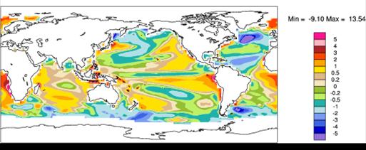
Figure 5: Annual-mean SST biases in CCSM3 1990 control run (Collins et al. 2005)
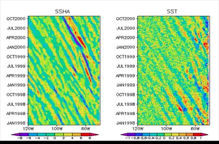 The maintenance of the SST distribution over the SEP is an important problem. The WHOI stratus buoy (85°W, 20°S) provides a unique opportunity to gain insight into the heat budget of a subtropical cool ocean regime well offshore of the coastal upwelling zone. In both the upwelling zone and further offshore, the flow is complex and time-varying. Satellite altimetry and SST maps reveals mesoscale eddies 50-200 km across (Fig. 6), Rossby waves, and coastally-trapped Kelvin waves playing an important role as in the Northeast Pacific (e.g. Kelly et al. 1998), but much less is known about these processes in the SEP.
Figure 6: Bandpassed satellite-derived sea-surface height and temperature meridionally averaged from 18-22°S. Note anomalies propagating westward at 5-10 cm s-1 (S-P Xie).
A scientific issue that VOCALS-REx aims to address is the role of this eddy and wave field in affecting SST well offshore by fluxing cold water out from the coastal upwelling regions. A preliminary study of the three-year mean heat budget at the WHOI stratus buoy suggests that heat flux divergence by mesoscale eddies is the most plausible process to balance the roughly 40 W m-2 net heat flux into the ocean measured at the buoy during this period.
A single measurement location provides an important anchor point, but is inadequate for understanding (i) what eddy or wave scales and structures dominate the eddy heat flux convergence; (ii) if this heat flux convergence is in fact as large as 20-40 W m-2; (iii) how far offshore the eddy heat flux convergence is significant; (iv) and how this affects the regional SST distribution.
VOCALS-REx will provide detailed measurements of the mesoscale variability of the upper ocean eddy field to determine their importance in the regional climate of the SEP.
Hypothesis 2a: Oceanic mesoscale eddies play a major role in the transport of heat and fresh water from coastally upwelled water to regions further offshore.
Testing strategy: The NOAA R/V Ronald H Brown (RHB) will be used to conduct two mesoscale surveys consisting of butterfly patterns 500 km on a side centered on 20°S, 77.5°W and 20°S, 85°W. While executing the butterfly patterns the RHB will tow the SeaSoar platform (Pollard 1986) which will be instrumented with a range of sensors to sample thermodynamics and nutrients and will drop XBTs at hourly intervals when transiting. An ADCP will also be used to determine the kinematic eddy structure and observe horizontal velocities. Mapping the horizontal velocity and temperature fields will allow estimation of the advective transports associated with the mesoscale variability at the two sites, of the water mass characteristics of eddies, and of the change in water mass characteristics as the eddies move offshore. That change is an indicator of the amount of mixing with the surrounding water. Mapping of nutrient concentrations as well as heat and salinity will provide additional insight into relevant mixing and transport processes and into the strong productivity of the waters offshore. Since nutrient-induced phytoplankton blooms can affect the depth over which sunlight is absorbed in the ocean column, nutrients may even be somewhat active tracers. These blooms may also contribute to biological production of aerosols. Drifters, with thermistor chains extending below the mixed layer base, will be deployed to examine horizontal homogeneity and better resolve smaller scale features and Lagrangian transports in the eddy field. Microstructure observations might provide useful constraints on the role of vertical mixing processes at selected locations within the eddy and current field. Strong vertical gradients in salinity and oxygen, with fresh, low oxygen water below the surface layer of the ocean, point to a good signal to noise ratio in observing vertical mixing. Altimetry will be used to put the SeaSoar and XBT sections into better spatial context. This would provide a rich context for understanding the long-term buoy time series and altimetry data, as a well as a comprehensive observational comparison with coupled and regional ocean model simulations, and thereby helping us better understand the role of lateral ocean mixing and eddy transports in setting the regional SST distribution of the SEP.
Coastal upwelling occurs on spatial scales smaller than those typically resolved in coupled ocean-atmosphere global circulation models. High resolution regional ocean models (e.g. Penven et al. 2005) broaden the context of the limited observations (e.g. Huyer 1980, Conkright et al. 2002) in suggesting that the depth and offshore extent of the northward flowing Humboldt current and the coastal upwelling varies markedly from location to location along the South American coast in response to varying bathymetry and coastal shape. Certainly, the upwelling regions in the NE Pacific exhibit strong geographic features that would be difficult to resolve with coupled ocean-atmosphere GCMs (Barth et al. 2000). There is also expected to be strong temporal variability in the upwelling strength, particularly along the Chilean coast where a southerly coastal jet is modulated in strength on subseasonal timescales (Garreaud and Muñoz 2005). As shown in Figure 5, coupled ocean-atmosphere models exhibit considerable biases in SST in regions of strong upwelling (Collins et al. 2005), and it is yet unclear to what extent these biases stem from poorly resolved coastal upwelling in these models. Observations from other important upwelling regions (Andreae et al. 1994) suggest that ocean productivity and biogenic aerosol precursors such as upper oceanic DMS are strongly tied to variability in local coastal upwelling, and so their production may therefore be poorly estimated in chemical transport climate models, which almost all assume fixed DMS sources (e.g Koch et al. 1999). This variability certainly impacts seawater DMS concentrations (Andreae 1985) and probably the sea-air DMS fluxes, although the relationship between DMS and satellite-observed chlorophyll is poorly understood (Matrai et al. 1993, Kettle et al. 1999). Over the SEP, there is considerable small scale variability in the upper ocean (e.g. Fig. 6), particularly in the coastal zone, but there are few measurements of DMS fluxes and their mesoscale variability over the SEP. There are few studies anywhere that have attempted to examine how variability in DMS fluxes might impact the mesoscale microphysical structure of aerosols and clouds.
Hypothesis 2b: Upwelling, by changing the physical and chemical properties of the upper ocean, has a systematic and noticeable effect on aerosol precursor gases and the aerosol size distribution in the SEP.
Testing strategy: DMS fluxes close to the ocean surface will be measured on both the C-130 and the RHB Relationships between these fluxes, the wind speed, and the thermodynamic and nutrient structure of the upper ocean will be assessed using shipborne upper ocean measurements from the RHB, and SST and ocean color measurements from the C-130 radiometers. The RHB will assess the sea water DMS variability using a fast SW DMS system during butterfly patterns and transits. We also plan to carry out approximately 5 ‘Cross-section’ missions designed primarily to examine aerosol and chemical contrasts between the coastal and more remote lower atmosphere (see the EDO for additional information on flight plans). These will involve characterization of the surface, MBL, and lower free-troposphere from the coast to 85°W along 20°S latitude. Links between the mesoscale variability in SST and DMS fluxes, the mesoscale ocean eddy and upwelling variability, and the structure of aerosols and aerosol precursors will be examined using these data.
Clouds over the SEP exhibit a much stronger diurnal cycle of cloud cover (Rozendaal et al. 1995) and cloud liquid water path (Wood et al. 2002) than the MBL clouds at comparable latitudes in the northern hemisphere. Regional model simulations (Garreaud and Muñoz 2004) suggest that a large-scale diurnal subsidence wave formed by the interaction of the coastal jet along the Chilean coast with dry convective heating over the western Andean slopes can travel at least 1000 km over the SEP and lead to a strong diurnal cycle of subsidence at remote locations. In the model, the phase of the wave strengthens the existing diurnal cycle of MBL depth and cloud liquid water path (LWP), with important potential impact upon albedo. Satellite wind observations (Wood, personal communication) provide some support for the model results, suggesting that the peak-to-peak amplitude of the subsidence at 85°W, 20°S may be 40-60% of the mean. This wave is also clearly seen in the operational ECMWF analyses (Fig. 7) as a response to the strong diurnal radiative heating on the Andean slopes. In addition, because the relationship between precipitation and LWP is strongly nonlinear (Comstock et al. 2004), the diurnal subsidence wave may impact the mean drizzle rate and its effects upon MBL structure and the rate of aerosol scavenging, but observations at higher temporal resolution and over a broader range of distances from the coast are required to demonstrate that the amplitude, phase, and vertical structure of the diurnal subsidence wave are accurately simulated by regional models.
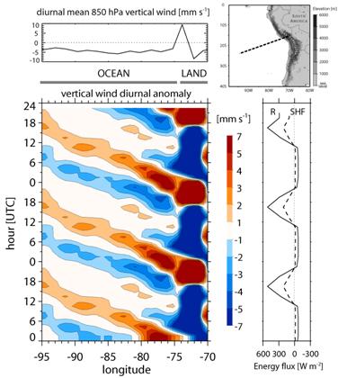
Figure 7: Characteristics of the diurnal subsidence wave emanating from the Andean slopes. Bottom left panel shows a Hovmoller vertical wind diurnal composite anomaly diagram from ECMWF operational analyses (Jul-Oct 2003) along the section shown on the map. The periods of strong ascent follow periods of strong dry heating on the Andean slopes (bottom right shows suface net radiative flux R and sensible heat flux SHF). Data courtesy of Martin Kohler, ECMWF.
Hypothesis 2c: The depth, phase speed, and vertical structure of the diurnal subsidence wave (“upsidence wave”) originating in northern Chile/southern Peru is well predicted using regional model simulations.
Testing strategy: A key signature of the diurnal subsidence wave is the diurnal cycle of temperature in the lower free troposphere (z<5 km). Rawinsonde observations of the lower tropospheric structure will be taken either 4 or 8 times per day from the RHB at different locations along 20°S during the 35 day cruise and will be composited to determine the amplitude and phase of the diurnal cycle as a function of the distance from the coast by compositing potential temperature anomalies as a function of local time. Additional lower free tropospheric data will be provided by wind profilers and rawinsonde ascents on both the Chilean and Peruvian coastal cruises planned for October 2007 (see the EDO for additional information). Together, this dataset will provide an unprecedented dataset detailing the diurnal cycle of the lower free troposphere from close to the western Andean slopes out to approximately 1000 km from the coast. Regional model simulations using MM5 will be run for the entire VOCALS-REx period by Rene Garreaud at the Universidad de Chile and will be compared with the observational composites. In addition, we will examine how well the diurnal wave is captured in two reanalysis products (NCEP and ECMWF). We will also use the model results and observations to determine the primary factors controlling the wave amplitude and phase, and attempt to address its role in modulating the diurnal cycle of cloud over the SEP.
2.3 Satellite retrieval evaluation
Satellite cloud observations are a key tool in assessing the magnitude of the indirect effects of aerosols on regional and global climate (e.g. Breon et al. 2002, Lohmann and Lesins 2002). Such assessments rely critically upon retrievals of cloud optical depth (t) and cloud effective radius (re). Of these, t estimates are the most widely used and well-characterized (Rossow and Garder 1993, Pincus 1995) and have been made routinely using geostationary and polar-orbiting satellites as part of the International Satellite Cloud Climatology Project (Rossow and Schiffer 1991). There has been a recent focus upon understanding and correcting errors in t related to subpixel cloud variability, including methods to account for partially filled pixels (Coakley and Bretherton 1982, Coakley and Davies 1985, Loeb and Coakley 1998, Barker et al. 2004). However, problems in estimating re in heterogeneous and broken clouds are considerably more serious than for t, are likely to have a more profound impact upon indirect effect estimates, and have received much less attention. This stems fundamentally from the retrieval methodology (termed the “visible-near infrared technique”, Twomey and Cocks 1982, Nakajima and King 1990, Nakajima et al. 1991), which typically uses two channels: the first, in the visible portion of the spectrum, is at a wavelength that is scattered, but not absorbed, by cloud droplets; the second, in the near-IR, is absorbed by cloud liquid water. The combination of the two allows an estimate of the ratio of absorption to scattering which is used to determine an estimate of re. The scattering itself is used to estimate t.
A key problem here is that because the sea surface is strongly absorbing whereas the cloud is weakly absorbing, a cloud that partially fills a satellite pixel can appear to be a strongly absorbing cloud leading to a considerable overestimate of re if the subpixel variability is not accounted for. Climatologies derived from satellite observations indicate a strong increase in re from the coastal regions to the trade wind regions further offshore (e.g. Fig. 2), which is interpreted as a reduction in the influence of continental aerosols upon clouds as they move away from land. However, morphological changes in the cloud structure from more overcast clouds near land to broken cumulus in the trades may introduce an important bias into the results which could cast doubt on conclusions concerning the extent of the anthropogenic influence upon clouds.
We are entering an era where it is possible to make spaceborne radar estimates of drizzle precipitation in stratocumulus clouds via the NASA Cloudsat mission (Stephens et al. 2002) and, later, the European Space Agency Earthcare program. Cloudsat is expected to lead to great strides in understanding the importance of precipitation (and its suppression by anthropogenic aerosols) upon the coverage and lifetime of low clouds over the remote oceans. At present, there are major gaps in our basic understanding of the climatology of precipitation over the subtropical oceans.
It is critical therefore that we establish the extent to which satellites can credibly inform us about the microphysical and precipitating properties of warm clouds.
Can satellite estimates of stratocumulus cloud microphysical properties (e.g. effective radius or cloud droplet number concentration from MODIS) and precipitation (from CloudSat or MODIS) be refined to perform in a satisfactory manner even under conditions of broken cloudiness on the pixel scale?
Strategy: The C-130 aircraft will provide in-situ cloud microphysical and bulk liquid water profiles during both the Cross-section and POCS-drift missions. Additionally, level runs a few km above cloud will be used to obtain (i) passive multichannel radiometer (MCR) imagery in the visible, near and thermal infrared at high horizontal resolution (~30 m); (ii) microwave radiometer (AIMR) imagery at 37 and 90 GHz with ~200 m horizontal resolution; (iii) active millimeter radar measurements at high vertical and horizontal resolution (10 m and ~100 m respectively. The MCR, with wavelength bands similar to those used in passive satellite microphysical retrievals, will provide cloud spatial variability information at a resolution that considerably exceeds those available from space (e.g. MODIS, GOES, and AVHRR). The AIMR provides microwave radiances needed to estimate cloud liquid water path at a resolution also much higher than the spaceborne equivalents (SSMI, TRMM TMI, AMSR-E) Together with the vertical profile of cloud structure from the downward pointing cloud radar, and the in-situ microphysics, these data will be used to assess the efficacy of passive visible/near IR and microwave retrievals of microphysical and bulk properties of broken and thin clouds. Coordination of flights with satellite overpasses will also be made where possible.